Key Points
- Cloudy conditions across the Seattle metropolitan area will give way to clear afternoon skies on Wednesday, initiating a steady multi-day warming trend.
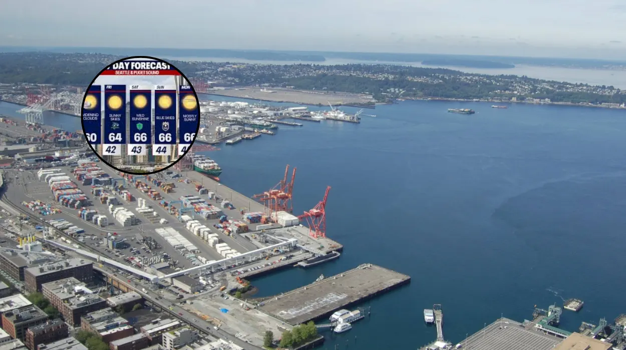
- High temperatures on Wednesday will climb into the mid-to-upper 60s, aligning the region with its seasonal average for late spring.
- An atmospheric ridge building over the Pacific is projected to bring dry, sunny conditions from Thursday through Saturday, with highs peaking in the mid-70s.
- Meteorological models track an upper-level trough arriving late Sunday, introducing cooler temperatures, increased cloud cover, and potential showers by Monday.
Seattle (Evening Washington News) May 20, 2026 – A distinct shift in regional atmospheric patterns is underway across western Washington, as a lingering layer of morning clouds transitions to clear skies and above-average temperatures. According to meteorological data released by local forecasting teams, daytime highs are projected to reach the mid-to-upper 60s across the Puget Sound lowlands before a substantial warming system establishes dry conditions through the latter half of the week.
This stabilization follows a cooler, unsettled pattern, signaling a temporary stretch of consistent late-spring sunshine for metropolitan residents and outdoor enthusiasts.
As detailed by meteorologist Claire Anderson of FOX 13 Seattle, the initial cloud cover observed during the morning hours of Wednesday will systematically disperse as high-pressure dynamics begin to strengthen over the Pacific Northwest.
This ridge of high pressure will gradually displace the marine layer that has dominated the immediate coastline and interior valleys. Analysts note that while morning temperatures remained subdued under a thick blanket of clouds, the arrival of solar radiation by mid-afternoon will rapidly elevate temperatures to levels typical for this time of May.
Forecasting units indicate that this clearing trend serves as the direct prelude to an extended warming period that will peak during the start of the weekend.
Data sets from the National Weather Service and regional broadcast networks confirm that consecutive days of dry weather will allow inland temperatures to climb approximately ten degrees above mid-week markers. However, long-range radar models suggest that this dry sequence will remain bounded by a secondary low-pressure system arriving early next week.
When Will the Cloud Cover Clear Across Western Washington?
As reported by forecasters Brian MacMillan and Ilona McCauley of FOX 13 Seattle, the regional weather transition will become visibly apparent by Wednesday afternoon.
The thick marine strata that blanketed metropolitan Seattle during the early hours are expected to erode from the interior outward, allowing full solar exposure to penetrate the Puget Sound basin. The high-pressure system driving this change is expanding northward, a pattern that climatologists frequently associate with the transition away from early-spring dampness.
The immediate consequence of this solar clearing is a marked rise in surface temperatures. Regional data sheets indicate that afternoon highs will consistently land between 65 degrees and 69 degrees Fahrenheit in urban areas.
While northern corridors near the San Juan Islands and locations directly fronting the Pacific coast may experience slightly lower maximums due to maritime breezes, interior sectors such as Bellevue, Tacoma, and Olympia are positioned to experience the full extent of the mid-week warmth.
How Long Will the Late-Week Warming Trend Last?
As documented in official updates by the FOX 13 Seattle weather team, a robust upper-level ridge is scheduled to take shape over the eastern Pacific Ocean starting Thursday morning.
This structural weather pattern acts as an atmospheric block, effectively diverting wet northern storm tracks away from western Washington and locking in high stability.
Under this system, daytime high temperatures are forecast to climb incrementally each day from Thursday through Saturday afternoon.
Meteorological charts project that by Friday and Saturday, the afternoon highs across the greater Seattle area will reach the mid-70s, establishing the warmest consecutive stretch of the month so far.
Environmental agencies note that accompanying this heat will be sustained low humidity and negligible wind speeds, creating optimal conditions for local agricultural operations and public recreation.
The prolonged absence of precipitation during these three days is expected to dry out surface soils that had accumulated moisture during previous low-pressure passages.
What Changes Will the Upcoming Upper-Level Trough Bring?
As stated by independent meteorological analyses and regional broadcast summaries, this period of elevated temperatures faces a definitive conclusion on Sunday.
A secondary weather feature, identified by atmospheric scientists as an upper-level trough, is currently tracking southward from the Gulf of Alaska.
This system is model-projected to breach the outer coastal perimeters by Sunday afternoon, weakening the high-pressure ridge and initiating a rapid cooling cycle.
The arrival of the trough will manifest initially as an onshore push, drawing cool, damp air from the Pacific Ocean back into the lowland interior.
Consequently, residents will observe building cloud layers throughout Sunday afternoon, accompanied by a sharp drop in ambient temperatures back into the low 60s.
Forecasters warn that as the core of the low-pressure system settles over the state, the probability of light-to-moderate showers will rise significantly late Sunday night, with scattered precipitation expected to persist well into Monday morning.
Background of the Pacific Northwest Spring Transitions
The rapid alternation between high-pressure ridges and low-pressure troughs observed in the current forecast is a foundational characteristic of the spring climate in western Washington. Locally referred to by atmospheric scientists as the transition between “May Gray” and “June Gloom,” this period involves intense competition between stabilizing continental air masses and moisture-laden marine systems.
During late May, the subtropical high-pressure systems over the eastern Pacific begin to expand northward, creating a vast sheet of low marine clouds offshore that are periodically shoved inland by shifting winds.
Historically, this back-and-forth oscillation ensures that sustained early-summer heat rarely establishes itself permanently before late June or early July.
The presence of the Cascade and Olympic mountain ranges further complicates these local patterns, trapping marine air within the Puget Sound lowlands and causing rapid shifts in visibility and temperature over short geographical distances.
The incoming mid-week clearing represents a brief victory for the expanding subtropical ridge before the broader sub-polar jet stream asserts itself via Sunday’s trough.
Outlook and Predictions for Regional Residents
The upcoming weather variations are poised to directly impact multiple segments of the local population, particularly those involved in outdoor industries, regional transport, and seasonal recreation.
The three-day window of dry conditions and mid-70s temperatures from Thursday to Saturday will significantly benefit construction crews and municipal road maintenance operations, allowing for uninterrupted concrete pours and asphalt paving that require dry surfaces.
Agricultural operations in the surrounding valleys will likewise utilize the dry period to advance planting schedules that were previously delayed by early-month dampness.
Conversely, the abrupt return of cloudy skies and potential showers late Sunday will alter traffic dynamics and public safety considerations for the Monday morning commute. The initial rain falling on dry, oil-filmed road surfaces after a multi-day dry spell is predicted to create slick driving conditions across major transit corridors, including Interstate 5 and Interstate 405.
Additionally, outdoor recreationalists planning excursions into Mount Rainier National Park or the Cascade backcountry are advised to prepare for rapid temperature drops and reduced visibility above the timberline as the upper-level trough arrives on Sunday.