Key Points
- Heavy Morning Showers: Intensely heavy downpours will move rapidly through the metropolitan area during the early morning hours on Tuesday.
- Transition to Scattered Rainfall: The persistent early morning downpours are expected to transition into more isolated, scattered showers as afternoon approaches.
- Onshore Low-Pressure Movement: A low-pressure weather system, which has been the primary driver behind the region’s recent cool temperatures and prolonged rainfall, has officially moved onshore.
- Atmospheric Instability: The migration of the low-pressure system onto land is forecasted to trigger significant atmospheric instability across the region by Tuesday afternoon.
- Puget Sound Convergence Zone Formation: Meteorological data indicates a strong likelihood of a Puget Sound Convergence Zone establishing itself around the Snohomish County area.
- Severe Local Weather Threats: The formation of the convergence zone brings a localized threat of heavy rainfall, lightning, and potential thunderstorms to specific northern sectors.
Seattle (Evening Washington News) June 9, 2026 – In what has been described by regional meteorologists as an unseasonably turbulent atmospheric event, residents across the Puget Sound region are preparing for a day of highly variable weather conditions on Tuesday. The National Weather Service and local broadcast networks have confirmed that a potent low-pressure system has officially moved onshore, fundamentally shifting the region’s immediate weather pattern from a steady, soaking rain into a highly volatile environment. Forecasters indicate that while the day will begin with widespread, heavy downpours, the meteorological landscape will rapidly fragment into scattered showers, gusty conditions, and localized thunderstorms by the afternoon hours.
- Key Points
- How Will the Puget Sound Convergence Zone Impact Snohomish County?
- What Rainfall Totals and Wind Speeds Are Expected Across the Lowlands?
- Why is This Cool, Wet Pattern Deviating from Long-Term Climate Trends?
- How Does the Current Moisture Deficit Impact Regional Hydrology?
- Background of the Particular Development
- Prediction
As reported by the FOX 13 Seattle Weather Team, the core of the meteorological disruption stems from an upper-level low-pressure system that has completed its transition from the offshore waters of the Pacific Ocean directly onto the West Coast landmass. This movement is expected to inject substantial instability into the upper layers of the atmosphere, creating conditions ripe for sudden weather changes.
The transition from a stable, cool rain into an active, convective setup means that while some neighbourhoods may experience brief sunbreaks, others could face intense, short-duration downpours accompanied by frequent lightning.
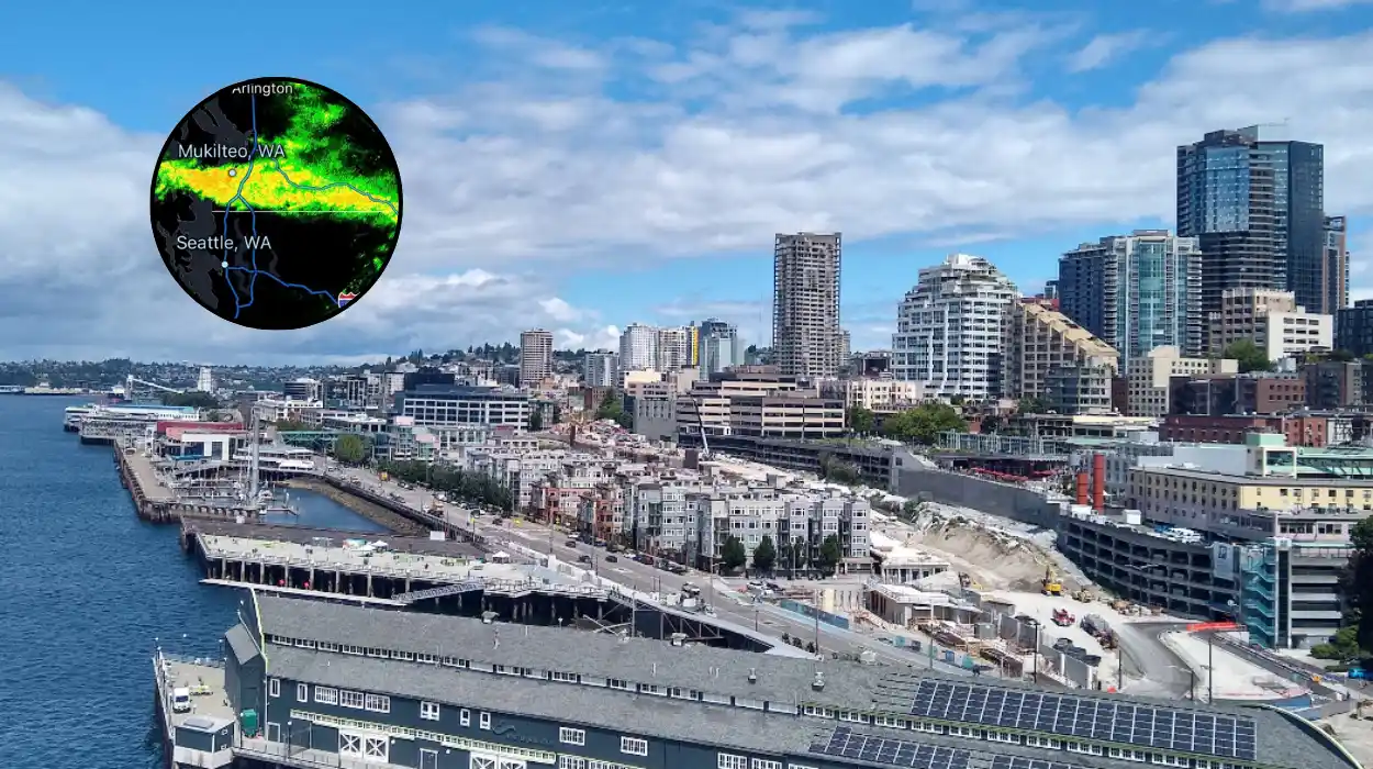
How Will the Puget Sound Convergence Zone Impact Snohomish County?
According to a comprehensive weather advisory published by Chief Meteorologist Brian MacMillan of KIRO 7 News Seattle, a primary focal point for Tuesday’s severe weather potential will be the formation of a prominent Puget Sound Convergence Zone.
This localized phenomenon occurs when air masses tracking around the Olympic Mountains collide in the lowland areas, forcing air upward and rapidly accelerating the development of convective clouds. Meteorological models strongly suggest that this zone will establish itself primarily over Snohomish County and the North Sound region.
In the detailed forecast notes compiled by MacMillan, it was observed that
“in the convergence zone, we will have the best chance of an isolated thunderstorm.”
Residents within this specific geographical corridor have been advised to remain alert for rapid reductions in visibility, sudden pooling of water on roadways, and dangerous cloud-to-ground lightning strikes. The localized nature of the convergence zone means that weather severity could vary drastically over just a few miles, leaving some northern suburbs under severe storm threats while southern areas experience standard scattered showers.
What Rainfall Totals and Wind Speeds Are Expected Across the Lowlands?
Writing for the National Weather Service (NWS) Seattle forecast discussion, veteran meteorologist Dana Felton highlighted that the moisture profile of this system remains highly efficient, despite its shifting structure.
In the official briefing documentation, the NWS staff noted that rainfall totals ranging from half an inch to potentially one full inch are entirely plausible across the lowland sectors, with the vast majority of that volume accumulating during the overnight hours and the earliest portions of Tuesday morning.
Furthermore, the system is bringing a significant wind component that will amplify the unseasonal feel of the weather.
The NWS Seattle station data indicates that the region will become notably breezy throughout Tuesday, with sustained southwest winds accelerating significantly. Regional forecasters have warned that widespread wind gusts peaking between 20 and 30 miles per hour will be common across the metropolitan area, a factor that will suppress apparent temperatures and make early June feel distinctly autumnal.
Why is This Cool, Wet Pattern Deviating from Long-Term Climate Trends?
The current unseasonably cool and wet reality on the ground presents a stark, short-term contrast to the broader climate narratives currently surrounding the Pacific Northwest.
In a specialized climate analysis published by the Emerald City Weather portal, it was revealed that this brief bout of instability is merely a temporary interruption to a much larger, historic warming trend dominating the region.
As reported by the editorial team at Emerald City Weather, the National Oceanic and Atmospheric Administration’s (NOAA) Climate Prediction Center recently issued its definitive 90-day outlook, assigning a stunning 60% to 70% probability that Seattle will ultimately record a warmer-than-average summer for the overall 2026 season.
Meteorologist Dana Felton of the National Weather Service in Seattle contextualized this data by stating to reporters that if the current federal long-range projections hold true,
“it would be the 14th consecutive Seattle summer that measured hotter than average,”
tracking data using the standard meteorological summer window of June 1 through August 31.
How Does the Current Moisture Deficit Impact Regional Hydrology?
The immediate rainfall provided by Tuesday’s low-pressure system, while disruptive to daily commutes, is being viewed by environmental scientists as a critical, albeit minor, hydrological relief. Background data provided within the Emerald City Weather report emphasizes that the region entered the traditional summer period at a distinct ecological disadvantage.
The Pacific Northwest experienced a exceptionally poor-performing winter regarding mountain snowpack accumulation, which has left regional water resource managers with significantly less “bankable water” in the form of melting snow than is typically required to sustain river flows and reservoir levels through the dry months.
Background of the Particular Development
The arrival of the June 9 low-pressure system represents a classic example of a “June Gloom” or “Junuary” setup, a atmospheric pattern deeply familiar to long-term residents of western Washington. Historically, the transition from spring to summer in the Pacific Northwest is rarely linear.
While late May and early June can occasionally feature prolonged periods of high pressure and clear skies, the region remains highly vulnerable to deep marine layers and fractured upper-level lows sliding down from the Gulf of Alaska or tracking eastward across the northern Pacific.
The specific mechanism driving Tuesday’s weather—the onshore migration of an offshore low—is historically responsible for the region’s most dramatic late-spring weather shifts. When these systems remain offshore, they draw cool, stable marine air across the lowlands, resulting in overcast skies and light, misty drizzle.
However, when the core of the low-pressure center physically crosses the coastline, the direct introduction of colder air aloft over a landmass that has been warmed by early summer sun creates a steep environmental lapse rate. This temperature differential between the surface and the upper atmosphere is the exact catalyst required to transform mundane Pacific Northwest rain into an active convective setup, driving the thunderstorms, convergence zones, and gusty wind regimes witnessed across western Washington.
Prediction
The immediate passage of this low-pressure system is predicted to give way to a rapid and historic meteorological turnaround that will directly impact the energy consumption habits, health precautions, and daily routines of Seattle residents.
Local meteorological models indicate that after the final remnants of Tuesday’s scattered showers and northern convergence zones clear the region on Wednesday morning, an exceptionally strong ridge of high pressure aloft will begin building across the West Coast and the northeast Pacific.
By the upcoming weekend, forecasters predict an optimal scenario for extreme heat as regional wind flows turn entirely offshore.
This atmospheric shift means that instead of receiving cooling maritime air masses off the Pacific Ocean, the Puget Sound basin will experience dry, warm winds descending the eastern slopes of the Cascade Mountains, warming adiabatically as they sink into the lowlands.
Current mid-range computer models are forecasting high temperatures to rocket well into the upper 80s by Sunday, with the potential to hit a record-breaking 90 degrees Fahrenheit by Monday.
For the local population, this drastic swing from a cool, breezy 60-degree Tuesday to a scorching 90-degree heatwave less than a week later poses distinct challenges. Because a significant percentage of older residential architecture in Seattle lacks centralized air conditioning systems, this rapid transition will likely trigger an immediate spike in localized heat-related illnesses and a historic surge in electrical grid demand as residents deploy portable cooling units.
Additionally, the sudden heat, arriving immediately on the heels of an already depleted winter snowpack, is predicted to accelerate the drying out of fine forest fuels, pulling the regional wildfire risk timeline forward significantly into mid-June.