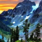
The North Cascades Scenic Drive traverses a pristine alpine wilderness ecosystem inside Washington State. Known formal designation as State Route 20, this 140-mile corridor constitutes the northernmost paved highway crossing the Cascade Mountain Range. The highway intersects dense ancient rain forests, engineered hydroelectric reservoir systems, and alpine environments that contain 312 active glaciers, a count exceeding any other protected park area in the contiguous United States.
- What is the geographic trajectory of the North Cascades Scenic Drive?
- Why does the North Cascades Scenic Highway close every winter?
- Which low-elevation stops introduce the Skagit River history?
- Why is Diablo Lake a mandatory viewpoint on Route 20?
- What high-altitude trails can drivers access directly from the highway?
- How should visitors prepare for the remote highway environment?
- What future environmental factors impact the scenic route?
The route serves as the primary transportation arterial for the North Cascades National Park Complex, established by an Act of Congress on September 2, 1968. The complex integrates three distinct administrative jurisdictions managed by the National Park Service: the North Cascades National Park North Unit, the North Cascades National Park South Unit, and the Ross Lake National Recreation Area. The highway is recognized as a National Scenic Byway, managed under infrastructural oversight from the Washington State Department of Transportation and the United States Forest Service.
Understanding the critical geographic, cultural, and technical stopping points along State Route 20 optimizes travel efficiency and ensures visitor safety within a dynamic alpine corridor.
What is the geographic trajectory of the North Cascades Scenic Drive?
The North Cascades Scenic Drive originates at the junction of Interstate 5 and State Route 20 in Burlington, Washington. The route extends eastward through the Skagit River Valley, crosses the alpine crest at Washington Pass, and terminates in the Methow Valley town of Twisp.
Macro Context and Gateway Corridors
The highway establishes an east-west transit system that links the marine environment of Puget Sound to the arid interior plains of Eastern Washington. The initial western sector of the highway progresses across alluvial flatlands before following the path of the Skagit River, a 150-mile waterway that acts as the principal drainage basin for the northern Cascade Range. This lower river valley contains low-elevation old-growth forests dominated by Douglas-fir (Pseudotsuga menziesii) and Western Redcedar (Thuja plicata).
As the geographic elevation increases, the highway enters the Skagit River Wild and Scenic River System, a federal designation enacted in 1978 to safeguard 125 miles of river channels across four distinct rivers: the Skagit, Cascade, Sauk, and Suiattle. These river channels supply spawning habitat for five species of Pacific salmon: Chinook, Coho, Pink, Chum, and Sockeye.
The Subalpine Transition and High-Elevation Crest
The intermediate sector of State Route 20 is situated within the Ross Lake National Recreation Area, where the topography transitions abruptly into vertical granite walls, hanging glaciated valleys, and deep fjord-like reservoirs. Here, the vegetation transforms into subalpine forest communities consisting of Western Hemlock (Tsuga heterophylla) and Pacific Silver Fir (Abies amabilis).
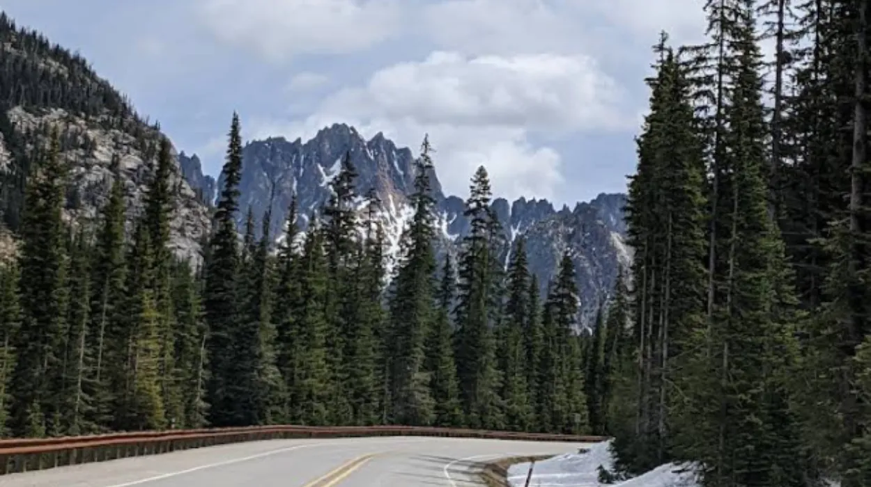
The easternmost mountain sector culminates at the subalpine drainage divide. The highway ascends through a sequence of sharp switchbacks to crest two prominent mountain passes: Rainy Pass at an elevation of 4,855 feet, followed by Washington Pass at an elevation of 5,477 feet. Beyond the Washington Pass summit, the road drops into the semi-arid rain shadow ecosystem of the Okanagan Dry Forests on the eastern slopes of the mountain range.
Why does the North Cascades Scenic Highway close every winter?
The Washington State Department of Transportation closes a 37-mile section of State Route 20 between milepost 134 and milepost 171 each winter due to severe avalanche risk. Accumulating snowpacks routinely exceed 15 feet across dozens of active chute corridors.
Technical Mechanics of Avalanche Chutes
The physical terrain surrounding Washington Pass and Rainy Pass contains steep, glaciated granite headwalls that form active avalanche paths. Heavy winter precipitation systems coming off the Pacific Ocean deposit dense, moisture-laden snow layers over thin crusts. The Washington State Department of Transportation monitors 30 named avalanche zones along this specific 37-mile highway envelope, including high-frequency paths such as the Liberty Bell Mountain chutes and the Whistler Mountain paths.
An avalanche involves the rapid downslope movement of snow, ice, and mountain debris down a hillside, often triggered when structural stress exceeds the shear strength of the base snowpack. Slides along State Route 20 frequently release thousands of tons of snow at velocities exceeding 80 miles per hour. The debris fills the roadway corridor with compacted snowpacks and fallen timber up to 40 feet deep.
Historical Infrastructure and Reopening Operations
The highway was officially completed and opened to vehicular traffic on September 2, 1972. Prior to this date, cross-state travel through the northern tier of Washington required long detours along southern mountain passes or river valleys. Because engineering a continuous permanent snowshed infrastructure over dozens of active chutes remains financially and structurally impractical, seasonal closure has been implemented every year since 1972.
The annual winter closure typically begins in November and extends through April or May. The spring reopening process requires specialized maintenance crews operating industrial machinery, including heavy rotary snowblowers, tracked bulldozers, and armored excavators. Maintenance personnel clear thousands of cubic yards of snow over a multi-week period while avalanche technicians use explosive charges to trigger controlled slides on unstable upper slopes, protecting workers below.
Which low-elevation stops introduce the Skagit River history?
The town of Marblemount, the North Cascades Visitor Center in Newhalem, and the Skagit Information Center introduce the region’s human and ecological history. These low-elevation facilities present interpretive data regarding native cultures, early mining, and industrial hydroelectric development projects.
The Gateway of Marblemount
Marblemount is situated at milepost 106, precisely where the Cascade River flows into the Skagit River. This site serves as the final municipal node providing commercial fuel, provisions, and communication infrastructure before travelers enter the wilderness areas of the national park. The Marblemount Wilderness Information Center, operated by the National Park Service, functions as the mandatory permitting station for backcountry climbers, overnight hikers, and high-altitude researchers entering the Stephen Mather Wilderness.
The geographic location marks a historical meeting ground where the Upper Skagit Indian Tribe harvested natural resources and traded with interior tribes via trans-mountain foot trails. The modern settlement grew rapidly during the gold and ruby mining rushes of the late 19th century, serving as a riverboat landing and pack-train staging post.
The Industrial Settlement of Newhalem
Newhalem is located at milepost 120 and operates as a company-owned town managed by Seattle City Light, the municipal electric utility for the City of Seattle. The town was constructed in the 1920s to house engineering personnel during the development of the Skagit River Hydroelectric Project. This massive infrastructural system consists of three major dams built to generate renewable municipal power: Gorge Dam, Diablo Dam, and Ross Dam.
The Newhalem historic district includes short footpaths that connect visitors to early industrial artifacts. The Trail of the Cedars consists of a 0.3-mile gravel loop traversing old-growth riverfront forest, utilizing a suspension footbridge to cross the main channel of the Skagit River. The Ladder Creek Falls trail features a historic rock garden and illumination system constructed by early superintendent James Delmage Ross in the 1930s to showcase the utility’s electrical capability to public investors.
The North Cascades Visitor Center
Situated across the river from the Newhalem townsite, the North Cascades Visitor Center offers dedicated educational exhibits detailing the geomorphology, climate shifts, and biological diversity of the ecosystem. The facility features three distinct relief maps illustrating the rugged structural terrain of the pick-et ranges and the path of localized glaciers.
Interpretive exhibits document the lifecycles of indigenous wildlife species, such as the mountain goat (Oreamnos americanus), the wolverine (Gulo gulo), and the bald eagle (Haliaeetus leucocephalus), which congregates in numbers exceeding 400 individuals along the Skagit River corridor every winter to feed on spawning salmon.
Explore More Things to do
Ross Lake National Recreation Area Travel Guide for Washington Visitors
Washington Alpine Lakes Guide: Hidden Mountain Beauty in Cascade Wilderness
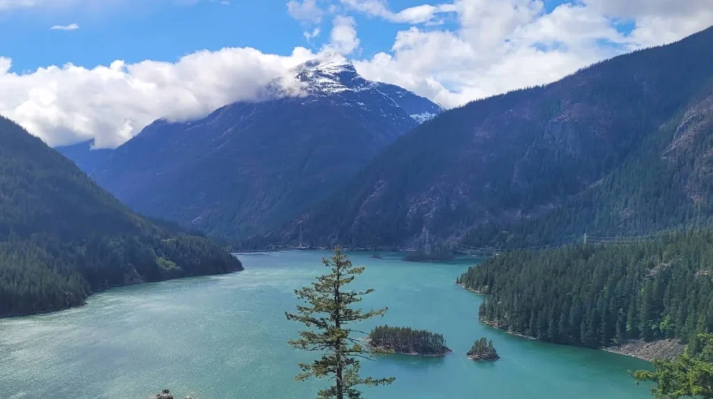
Why is Diablo Lake a mandatory viewpoint on Route 20?
Diablo Lake is a mandatory stop at milepost 132 because its intense turquoise water offers direct visual evidence of active glacial erosion. The overlook provides expansive vistas of high alpine peaks rising over 4,000 vertical feet above the reservoir surface.
The Science Behind the Turquoise Water
The distinct hue of Diablo Lake is the direct result of a physical geological process called glacial pulverization. The active alpine glaciers resting on surrounding peaks—such as Colonial Peak and Pyramid Peak—slowly grind the underlying bedrock as they advance and retreat down the mountain slopes. This continuous friction creates an ultra-fine sediment called rock flour or glacial flour.
During the summer melt season, subglacial streams transport this fine sediment down into the reservoir. Because the rock flour particles are extraordinarily light and fine, they remain suspended in the upper water column rather than sinking to the lakebed. When sunlight strikes the surface of the reservoir, these suspended mineral particles absorb the longer wavelengths of light (reds and purples) while reflecting the shorter wavelengths (blues and greens), producing a bright turquoise color.
Engineering and Geomorphic Vistas
The Diablo Lake Overlook features a large paved parking lot, descriptive interpretive signage, and wheelchair-accessible concrete walkways built directly onto a prominent rock promontory. From this point, visitors can see the expanse of the reservoir, which was created when Diablo Dam was completed in 1930. At the time of its construction, the 389-foot-tall concrete arch structure stood as the tallest dam on Earth.
Looking south from the overlook, the view contains several towering topographic features:
- Davis Peak: A steep granite mass rising north of the lake to an elevation of 7,051 feet.
- Colonial Peak: A glaciated summit to the south reaching an elevation of 7,771 feet.
- Pyramid Peak: A sharp pyramid-shaped peak standing directly above the lake at 7,182 feet.
- Buster Brown Island: A small, forested island visible in the center of the reservoir channel, representing a resilient un-eroded bedrock knob left behind by ancient valley-carving glaciers.
What high-altitude trails can drivers access directly from the highway?
Drivers can access the Heather-Maple Pass Loop and the Blue Lake Trail directly from the high-elevation trailheads located near the highway summit. These routes provide fast access to fragile subalpine meadows and pristine glacial tarns.
The Heather-Maple Pass Loop
The trailhead for the Heather-Maple Pass Loop is located at the Rainy Pass picnic area at milepost 158. This 7.2-mile subalpine hiking loop features a demanding 2,000-foot vertical elevation gain, reaching a maximum ridge crest of 6,650 feet. The trail cuts through distinct ecological zones, beginning in dense silver fir forests before emerging into open alpine meadows characterized by heather heather (Phyllodoce empetriformis) and sitka valerian (Valeriana sitchensis).
The ridge crest offers clear views of the surrounding topography, including the deep depressions of Lake Ann and Rainy Lake, which occupy classic glacial cirques—bowl-shaped mountain hollows carved out by historical ice masses. The loop trail also intersects a segment of the Pacific Crest National Scenic Trail, a 2,650-mile wilderness footpath spanning from the United States border with Mexico to the United States border with Canada.
The Blue Lake Trail
The Blue Lake Trailhead is situated farther east at milepost 161, sitting at an initial staging elevation of 5,150 feet. This 4.4-mile round-trip trail features a moderate 1,050-foot elevation gain, making it accessible to a wider demographic of park visitors. The trail utilizes a series of raised boardwalks to protect fragile wetlands before ascending through subalpine larch forests (Larix lyallii).
The destination is a deep, cold subalpine tarn nestled directly against the vertical western headwall of Early Winters Spires. The water maintains a dark blue color because of its deep basin structure and low sediment load. The surrounding talus slopes provide important nesting and foraging habitat for small montane mammals, including the American pika (Ochotona princeps) and the hoary marmot (Marmota caligata).
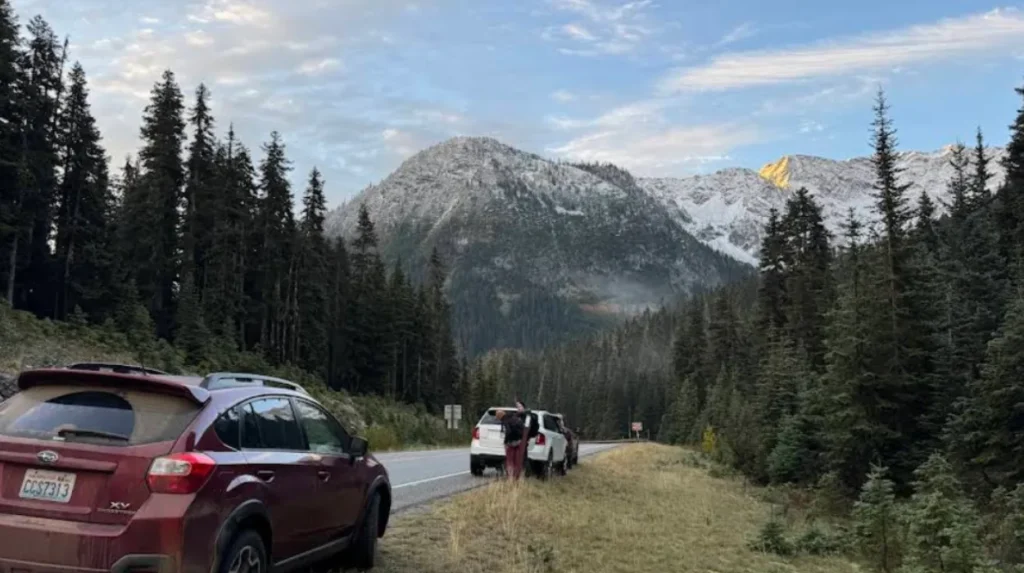
How should visitors prepare for the remote highway environment?
Visitors must plan for a completely remote wilderness environment by fueling vehicles completely, packing emergency supplies, and verifying road conditions. There are no commercial services or cellular networks over a continuous 60-mile stretch of the highway.
Fuel and Mechanical Contingencies
The 60-mile mountain core between Marblemount and Mazama contains no commercial gas stations, electric vehicle charging stations, or mechanical repair facilities. Drivers must monitor fuel gauges and battery levels prior to exiting the western urban corridors. Operating a vehicle through steep mountain passes requires significant energy expenditure; the ascent to Washington Pass includes sustained road grades of up to six percent.
Vehicular brake systems experience high thermal stress during the long descent from the passes. Drivers should utilize low-gear transmission settings to manage vehicle speed through engine braking, avoiding dangerous brake pad overheating and potential structural failure.
Communication Realities and Environmental Regulations
Cellular telephone service is unavailable from milepost 121 to milepost 170 due to the blocking effect of the steep topography and the absence of commercial transmission towers. Travelers should not rely on mobile internet applications for navigation or emergency communication. It is critical to download digital offline maps or carry physical topographic maps published by the United States Geological Survey before departing.
| Aspect | Detail / Requirement |
| Cellular Coverage Barrier | No signal between Milepost 121 and Milepost 170 |
| Backcountry Permit Authority | Wilderness Information Center (Marblemount) |
| Vehicle Grade Management | Sustained 6% ascents/descents near passes |
| Waste Disposal Standard | Pack It In, Pack It Out (Zero public trash cans) |
The National Park Service enforces strict Leave No Trace environmental protocols across the entire highway corridor to protect the ecosystem from degradation:
- Pack It In, Pack It Out: All consumer garbage must be stored securely inside vehicles and transported out of the park complex. There are no public trash receptacles along the highway pullouts.
- Wildlife Storage Regulations: All food items, scented cosmetics, and organic waste must be stored inside hard-sided vehicles or approved bear-resistant containers to prevent habituating black bears (Ursus americanus) and grizzly bears (Ursus arctos horribilis) to human food sources.
- Preservation of Alpine Flora: Hikers must stay centered on established trail treads. Subalpine soils and plants have short growing seasons and can take decades to recover if damaged by foot traffic.
What future environmental factors impact the scenic route?
Accelerated glacial retreat and increasing wildfire frequencies present long-term challenges to the infrastructure and natural preservation of the North Cascades corridor. Rising regional temperatures continue to alter the area’s hydrology and forest ecology.
The Process of Glacial Mass Deficit
The 312 active glaciers within the North Cascades ecosystem serve as critical frozen reservoirs that stabilize regional river systems. Systematic monitoring conducted by the National Park Service Glacial Monitoring Program documents a steady decrease in total glacial volume and surface area over the past several decades.
As winter snowpacks melt earlier and summer alpine temperatures rise, these glaciers experience a net mass deficit, meaning winter accumulation fails to offset summer melting. The long-term loss of these ice sheets alters the hydrology of the Skagit River basin:
- Late-Summer Streamflow Reduction: Glacial meltwater provides up to forty percent of late-summer water volumes in regional rivers. As glaciers shrink, streamflows drop, reducing water availability for downstream municipal hydroelectric generation.
- Water Temperature Elevations: Lower water volumes lead to higher stream temperatures. When water temperatures exceed critical thresholds, it causes reproductive stress and increased mortality rates for protected salmon species.
Wildfire Dynamics and Slope Instability
The increasing dryness of the subalpine forests has led to larger, more frequent wildfires along the State Route 20 corridor. High-intensity fires kill tree root systems that bind loose glacial till and fractured granite soils to steep mountainsides.
Following a severe wildfire event, the affected slopes become highly vulnerable to debris flows, mudslides, and rockfalls, particularly during heavy autumn rainstorms. These geological events can deposit tons of rock and mud onto the highway, damaging the roadway and requiring expensive engineering repairs by state highway crews to restore safe passage across the Cascade Range.
What is the North Cascades Scenic Drive?
The North Cascades Scenic Drive is a 140-mile route along State Route 20 in Washington State. It is the northernmost paved highway crossing the Cascade Mountains and passes through forests, alpine landscapes, glaciers, reservoirs, and parts of the North Cascades National Park Complex.