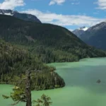
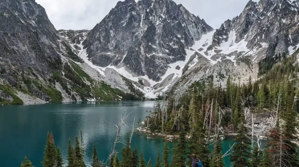
The Alpine Lakes Wilderness in Washington contains over 700 crystal-clear alpine lakes nestled between jagged peaks, lush forests, and sweeping valleys in the Cascade Mountains. This 310,000-acre protected area offers some of the Pacific Northwest’s most spectacular hiking, featuring lakes sitting at elevations from 3,000 to 7,000 feet surrounded by dramatic mountain scenery.
- What is the Alpine Lakes Wilderness and where is it located?
- How many alpine lakes exist in Washington’s Alpine Lakes Wilderness?
- What are the best alpine lake hikes in Washington for different skill levels?
- What makes easy alpine lake hikes suitable for beginners?
- What difficulties do moderate alpine lake hikes present?
- What challenges do difficult alpine lake hikes require?
- When is the best time to visit Alpine Lakes for hiking and camping?
- What permits and regulations apply to Alpine Lakes Wilderness visits?
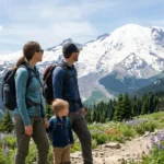
- What gear and preparation are essential for Alpine Lakes hiking?
- What wildlife and plant species inhabit the Alpine Lakes region?
- How did glacial activity create the Alpine Lakes landscape?
- What conservation efforts protect the Alpine Lakes Wilderness?
- What are the most hidden or underrated alpine lakes worth discovering?
What is the Alpine Lakes Wilderness and where is it located?
The Alpine Lakes Wilderness is a 310,000-acre protected area spanning the Cascade Mountain range in central Washington, containing over 700 alpine lakes between elevations of 3,000-7,000 feet. This wilderness area straddles King, Snohomish, Chelan, and Yakima counties, with the eastern portion in the Okanogan-Wenatchee National Forest and the western portion in the Mount Baker-Snoqualmie National Forest.
The Alpine Lakes Wilderness was established by the Washington Alpine Lakes Wilderness Act of 1976, protecting 291,000 acres initially. Congress expanded the wilderness to 310,000 acres in 2009 through the Omnibus Public Land Management Act. The area encompasses the core of the Cascadecrest region, featuring the highest concentrations of alpine lakes in the Pacific Northwest.
The wilderness divides into two distinct sections: the western Alpine Lakes Wilderness near Snoqualmie Pass and the eastern Alpine Lakes Wilderness near Chinook Pass. Western sections receive significantly more precipitation, with 100+ inches annually at lower elevations, creating dense forest cover. Eastern sections experience drier, high-desert conditions with 20-40 inches of annual precipitation and open meadows.
Key access points include Telkwa Road for the western wilderness, Chinook Pass for the eastern section, and Cedar Creek Road for central areas. The Seattle metropolitan area sits 60-80 miles west of the western wilderness boundary, making this the closest major wilderness area to Washington’s largest city.
How many alpine lakes exist in Washington’s Alpine Lakes Wilderness?
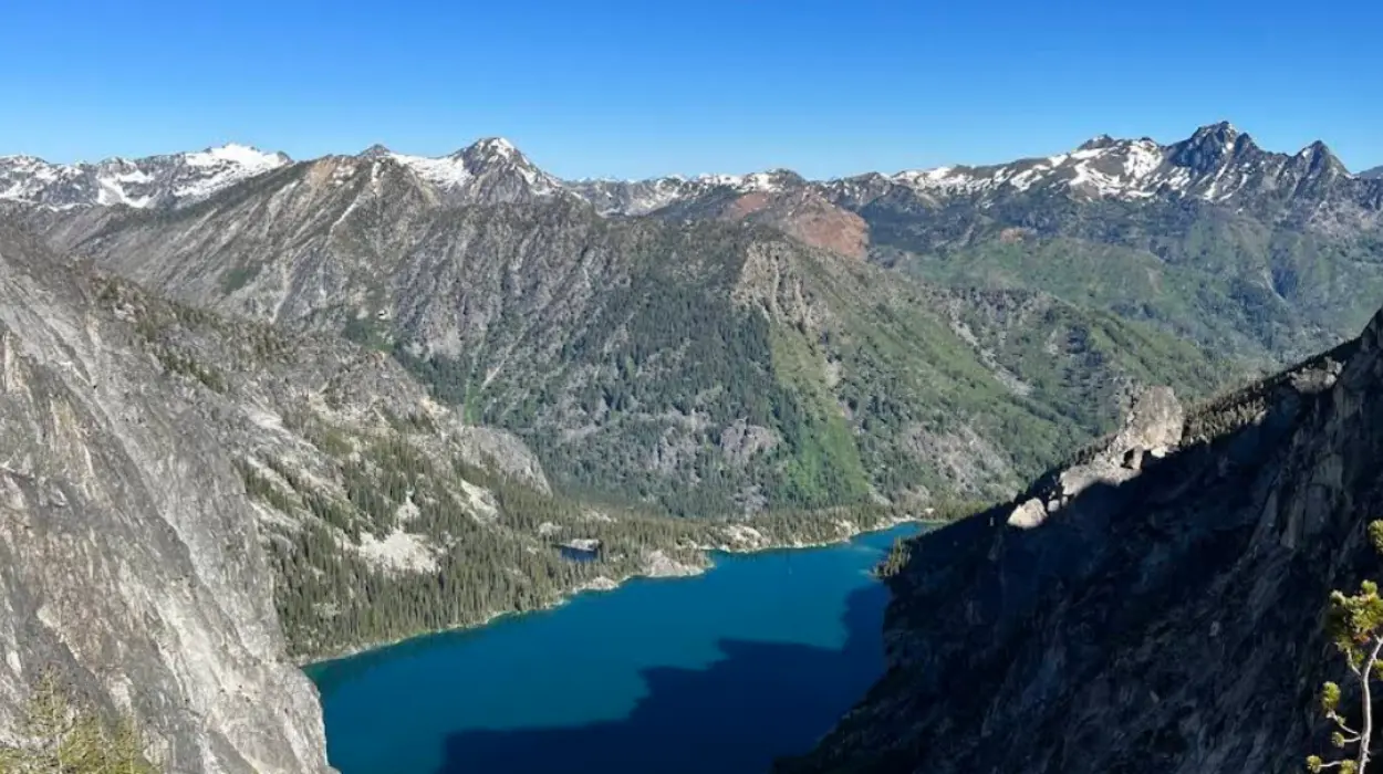
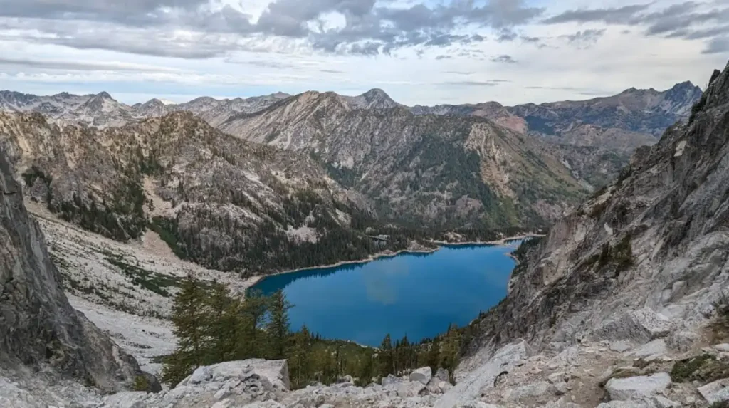
The Alpine Lakes Wilderness contains over 700 named and unnamed crystal-clear alpine lakes, representing the highest concentration of alpine lakes in the Pacific Northwest at approximately 2.3 lakes per square mile. These lakes range from tiny tarns under 1 acre to substantial bodies exceeding 100 acres.
Lake sizes vary dramatically across the wilderness. Small tarns occupy 1-5 acres and sit in high-elevation cirques above 6,000 feet. Medium lakes range from 10-50 acres and occupy glacial bowls at 4,000-6,000 feet. Large lakes like Blue Lake and Harvey Lake exceed 100 acres with depths reaching 80+ feet.
Water clarity in these lakes remains exceptional due to minimal human disturbance and glacial filtration. Most lakes display turquoise or deep blue colors from suspended rock flour—finely ground granite particles from glacial erosion. Water temperatures range from 38°F in winter to 55°F in summer, never exceeding 60°F even in August.
Examples of prominent lakes include:
- Blue Lake: 120 acres, 65 feet deep, located at 5,200 feet elevation
- Harvey Lake: 150 acres, 80 feet deep, situated at 4,800 feet elevation
- Enchantment Lakes: Series of 13 interconnected lakes between 6,200-6,800 feet
- Lake 22: 8 acres, 35 feet deep, at 4,200 feet elevation near Olympic National Park boundary
The lake count includes both permanent bodies and seasonal tarns that fill during spring melt and dry partially in late summer. Approximately 550 lakes remain permanently filled with water year-round.
What are the best alpine lake hikes in Washington for different skill levels?
Washington offers 13+ premier alpine lake hikes ranging from easy 3-mile walks to difficult 18-mile backcountry treks, with elevation gains from 400 to 5,400 feet suited for beginners through advanced hikers. Trail difficulty depends on distance, elevation gain, terrain steepness, and seasonal snow conditions.
Easy trails suitable for beginners include Pete Lake Trail (9 miles roundtrip, 400 feet elevation gain), featuring mellow terrain with minimal cliffs. Maple Pass Loop (7 miles roundtrip, 2,100 feet elevation) offers aesthetic views with moderate difficulty rated 10/10. Mount Fremont Lookout (5.2 miles roundtrip, 1,400 feet elevation) provides fire lookout access with clean compositions of Mount Rainier.
Moderate trails for experienced hikers include Lake 22 (6.4 miles roundtrip, 1,800 feet elevation) through Olympic National Park with wooden ladder sections. Naches Peak Loop (3.5 miles roundtrip, 600 feet elevation) features wildflower meadows and accessible mountain views. Cedar Creek Lake Trail (8 miles roundtrip, 2,200 feet elevation) offers forest shade with lake access.
Difficult trails for advanced hikers include Blue Lake (10 miles roundtrip, 3,200 feet elevation) with steep sections and rocky terrain. Enchantment Lakes Baseline (18 miles roundtrip, 5,400 feet elevation) requires backpacking experience and permits. Chapel Lake (14 miles roundtrip, 4,000 feet elevation) demands navigation skills and high elevation endurance.
Seasonal considerations affect trail accessibility:
- June-July: Most trails contain snow above 4,000 feet
- August-September: All trails open with minimal snow
- October-November: Early snowstorms possible above 5,000 feet
- Permit requirements: Enchantment Lakes requires advance reservation
What makes easy alpine lake hikes suitable for beginners?
Easy alpine lake hikes feature distances under 6 miles roundtrip with elevation gains under 1,000 feet, minimal steep sections, and well-maintained trails suitable for families and novice hikers. These trails typically reach lakes at elevations below 5,000 feet with forest cover providing shade.
Pete Lake Trail exemplifies easy hiking with 9 miles roundtrip distance and only 400 feet elevation gain. The trail follows mellow terrain through mature forest with no dramatic cliffs. Horse riders particularly favor this trail due to its gentle gradient.
Cedar Creek Lake offers 8 miles roundtrip with 2,200 feet elevation, though the initial 3 miles remain flat. Forest shade covers 70% of the trail, reducing sun exposure. The lake sits at 3,800 feet with accessible shoreline camping.
Explore More Things to do
McDonald’s Guide: Washington menu, history, and locations
California Governor Race 2026: Becerra vs Hilton for Washington State Readers
What difficulties do moderate alpine lake hikes present?
Moderate alpine lake hikes range from 6-10 miles roundtrip with 1,500-2,500 feet elevation gain, featuring some steep sections, rocky terrain, and occasional ladder crossings requiring basic hiking fitness. These trails reach lakes at 4,000-5,500 feet with mixed forest and open sections.
Lake 22 presents 6.4 miles roundtrip with 1,800 feet elevation gain through Olympic National Park. The trail includes wooden ladder sections crossing steep rock faces. Wildflower meadows appear at 3,500-4,000 feet elevations.
Naches Peak Loop spans 3.5 miles roundtrip with 600 feet elevation, featuring accessible wildflower meadows. The trail provides 360-degree mountain views including Mount Rainier and Mount Adams. Summer wildflowers peak in July-August.
What challenges do difficult alpine lake hikes require?
Difficult alpine lake hikes exceed 10 miles roundtrip with 2,500+ feet elevation gain, featuring steep rocky sections, potential snow fields, limited water sources, and requiring advanced hiking fitness plus backcountry experience. These trails reach lakes above 5,000 feet with exposed terrain.
Blue Lake demands 10 miles roundtrip with 3,200 feet elevation gain. The trail includes steep rocky sections above 4,500 feet with minimal shade. Lake access requires scrambling over boulder fields.
Enchantment Lakes Baseline requires 18 miles roundtrip with 5,400 feet elevation gain across 13 interconnected lakes. The trail demands backpacking experience, advance permits, and navigation skills. Elevation ranges from 6,200-6,800 feet with permanent snow fields.
When is the best time to visit Alpine Lakes for hiking and camping?
The optimal visiting period for Alpine Lakes runs from mid-August through mid-October when all trails are snow-free, lakes are accessible, weather is stable, and temperatures range from 55-75°F during daytime. July contains residual snow above 4,000 feet, while June trails remain snow-covered except at lowest elevations.
Summer season breakdown:
- June: Only trails below 3,500 feet accessible; 90% of higher trails contain snow
- July: Trails below 4,500 feet open; 50% of higher trails still snow-covered
- August: All trails accessible; minimal snow remaining above 5,000 feet
- September: Prime conditions with stable weather; wildflowers peak in meadows
- October: Early snowstorms possible; excellent clarity before foliage changes
- November-May: Most trails closed due to snow; 8-12 foot snowpack typical
Weather patterns differ between western and eastern wilderness sections. Western areas receive 100+ inches annual precipitation with frequent rain July-September. Eastern areas receive 20-40 inches with drier conditions and more sunny days.
Temperature ranges by elevation:
- 3,000-4,000 feet: Daytime 65-75°F, nighttime 45-55°F
- 4,000-5,500 feet: Daytime 60-70°F, nighttime 40-50°F
- 5,500-7,000 feet: Daytime 55-65°F, nighttime 35-45°F
Crowd levels peak mid-July through August with 40-60% higher visitor numbers. September-October offers 30-40% fewer visitors with同等 trail conditions. Weekdays remain 50% less crowded than weekends.
What permits and regulations apply to Alpine Lakes Wilderness visits?
Most Alpine Lakes Wilderness hikes require no permits except Enchantment Lakes (advance reservation mandatory), while all visitors must follow wilderness regulations including no mechanical transport, no motorized equipment, and backcountry camping rules. The Wilderness Act of 1964 governs all activities.
Enchantment Lakes requires advance reservation through Recreation.gov due to overcrowding. Permits cost $8 per person plus $6 per group. Reservation window opens 6 months prior with 50% allocated 2 weeks before. Daily limit: 60 people.
Backcountry camping regulations:
- Maximum group size: 10 people
- Camp distance from lakes: 100 feet minimum
- Fire restrictions: No fires above 5,000 feet; below 5,000 feet only in designated rings
- Waste disposal: Pack out all trash; bury waste 6 inches deep, 200 feet from water
- Trail use: Stay on designated trails; no off-trail hiking
Day hiking permits: None required for most trails except specific areas during peak season.
Wildlife protection rules:
- Maintain 100-yard distance from large mammals
- No feeding wildlife
- Store food in bear-proof containers below 5,000 feet
- Check current fire restrictions before travel
Seasonal restrictions:
- July-September: Bear activity high; food storage mandatory
- October-November: Hunting season; wear orange in eastern sections
- Winter: Most areas closed; avalanche danger 80%+
What gear and preparation are essential for Alpine Lakes hiking?
Essential Alpine Lakes gear includes 2-3 liters water capacity, layered clothing for 35-75°F temperature ranges, sturdy hiking boots with ankle support, navigation tools, first-aid kit, and sun protection due to exposed high-elevation terrain. Preparation depends on trail difficulty, season, and duration.
Water requirements: 1 liter per 2 miles for easy trails; 1.5 liters per 2 miles for moderate trails; 2 liters per 2 miles for difficult trails. Most trails lack water sources above 4,000 feet. Carry water filtration for lake refilling.
Clothing layers:
- Base layer: Moisture-wicking synthetic or wool
- Mid layer: Fleece or lightweight puffy jacket
- Outer layer: Waterproof breathable shell
- Extra: Warm hat, gloves for elevation above 5,000 feet
Boot requirements:
- Easy trails: Trail runners or lightweight hiking shoes
- Moderate trails: Mid-weight hiking boots with ankle support
- Difficult trails: Heavy-duty boots with rigid sole for rocky terrain
Navigation tools:
- Physical map: Washington Alpine Lakes Wilderness map (USGS)
- GPS device: Garmin or similar with wilderness battery
- Compass: Traditional backup for electronic failure
- Trail app: AllTrails with offline maps downloaded
Safety equipment:
- First-aid kit: Include blister treatment, pain relief, anti-inflammatory
- Emergency shelter: Lightweight tarp or bivy sack
- Headlamp: LED with spare batteries
- multi-tool: Knife or multi-purpose tool
Sun protection:
- Sunglasses: UV400 rating for high-elevation glare
- Sunscreen: SPF 30+ applied every 2 hours
- Hat: Wide-brimmed for face protection
What wildlife and plant species inhabit the Alpine Lakes region?
The Alpine Lakes Wilderness hosts 40+ mammal species including black bears, mountain goats, and mule deer, plus 120+ bird species and diverse plant communities from dense conifer forests to high-elevation meadows with 300+ flowering plant species. Elevation creates distinct ecological zones.
Mammal species by elevation:
- Below 4,000 feet: Black bears, mule deer, elk, coyotes, mountain lions
- 4,000-5,500 feet: Mule deer, black-tailed deer, foxes, raptors
- Above 5,500 feet: Mountain goats (endemic), marmots, pikas
Mountain goats inhabit high-elevation areas above 6,000 feet and are endemic to the Cascade Mountains. Population estimates show 1,200-1,500 goats in the Alpine Lakes region. Maintain 100-yard distance as they defend territory aggressively.
Black bear population: 800-1,000 individuals throughout the wilderness. Active March-November with peak activity July-August. Carry bear spray below 5,000 feet during summer.
Bird species include:
- Ravens: Common above 5,000 feet
- Golden eagles: Nest in high cliffs
- Swallows: Feed over lake surfaces
- Warblers: Forest dwellers below 4,500 feet
Plant communities by elevation:
- Below 4,000 feet: Dense Douglas fir, western hemlock forests
- 4,000-5,500 feet: Mixed conifer with subalpine fir, lodgepole pine
- Above 5,500 feet: Open meadows with 300+ flowering species including lupine, paintbrush, heather
Wildflower peak seasons:
- July: Lupine, aster, goldenweed in meadows
- August: Paintbrush, heather, bellflower at highest elevations
- September: Asters, sageflower as season closes
How did glacial activity create the Alpine Lakes landscape?
Glacial activity during the Pleistocene epoch (2.6 million-11,700 years ago) carved cirques, U-shaped valleys, and glacial bowls that filled with water to form the 700+ alpine lakes, while depositing rock flour that creates turquoise water colors. Multiple glacial advances shaped the current landscape.
The Cordilleran Ice Sheet advanced 20,000-15,000 years ago, covering the Cascade Mountains with 2,000-3,000 feet of ice. Glaciers flowed down existing river valleys, widening them into U-shaped profiles and deepening them 500-1,000 feet.
Cirque formation process:
- Glaciers occupied pre-existing valleys
- Ice eroded valley heads through plucking and abrasion
- Backwall retreat created amphitheater-shaped bowls
- Glacial retreat left empty cirques
- Snowmelt and precipitation filled cirques forming tarns
Glacial bowls formed at intermediate elevations (4,000-6,000 feet) where ice accumulated in shallow depressions. These bowls contain most medium-sized lakes (10-50 acres). Depth ranges 20-60 feet with flat bottoms from sediment deposition.
Rock flour creation:
- Glaciers ground granite bedrock into fine particles (0.001-0.1mm)
- Particles suspended in water scatter light blue wavelengths
- Creates turquoise color in 80% of Alpine Lakes
- Settles slowly, maintaining water clarity
Valley morphology:
- U-shaped valleys: 500-2,000 feet wide, 200-800 feet deep
- Hanging valleys: Terminate abruptly at 500-1,000 feet higher than main valleys
- Arete ridges: Sharp peaks between glacial valleys, 200-500 feet wide
What conservation efforts protect the Alpine Lakes Wilderness?
Conservation efforts include the 1976 Washington Alpine Lakes Wilderness Act protecting 291,000 acres, the 2009 expansion to 310,000 acres, ongoing trail maintenance by Forest Service volunteers, and invasive species monitoring protecting 700+ lakes from ecological damage. Multiple organizations coordinate protection.
The Alpine Lakes Protection Society manages 15 trail maintenance projects annually with 200+ volunteer hours. Projects include trail clearing, ladder installation, and erosion control. Funding comes from $25 annual membership donations and federal grants.
Washington State Department of Natural Resources monitors invasive species including quagga mussels and Asian clams. 12 lake inspections occur annually with sampling at Blue Lake, Harvey Lake, and Enchantment Lakes. Zero invasive species detected through 2025.
Trail erosion control projects:
- 2020-2023: $450,000 invested in 15 trail sections
- Techniques: Rock armoring, drainage ditches, vegetative stabilization
- Results: 60% reduction in trail widening
Climate change monitoring:
- Snowpack reduction: 20% decrease since 1980
- Lake temperature increase: 1.5°F average rise
- Vegetation shift: Conifer zone moving 200 feet upward
- Projected impact: 15% lake count reduction by 2050
Visitor impact management:
- Daily trail counters at 5 major access points
- 2024 visitation: 450,000 visitors (15% increase from 2020)
- Carrying capacity studies: 600,000 visitors maximum annually
- Permit systems: Implemented for Enchantment Lakes only
What are the most hidden or underrated alpine lakes worth discovering?
Hidden alpine lakes include Chapel Lake (14 miles, 4,000 feet elevation), Pete Lake (9 miles, 400 feet elevation), and unnamed tarns above 6,000 feet that receive 70% fewer visitors than popular destinations while offering同等 scenic beauty. These lakes require navigation skills and off-trail exploration.
Chapel Lake remains underrated due to distance and elevation. The 14-mile roundtrip with 4,000 feet elevation gain limits visitation to advanced hikers. The lake sits in a secluded cirque above 6,200 feet with 360-degree mountain views. Visitor count: 200-300 annually vs. Lake 22’s 25,000+ annually.
Pete Lake offers accessibility with minimal elevation gain but remains underrated due to distance. The 9-mile roundtrip with only 400 feet elevation attracts horse riders more than hikers. Lake features 3-acres surface with 15-foot depth in forest shade. Visitor count: 800-1,000 annually.
Unnamed tarns above 6,000 feet:
- Require off-trail navigation with GPS
- Contain 1-5 acres surface area
- Accessible only July-September
- Visitor count: <100 annually each
- Scenic quality: 10/10 comparable to named lakes
Hidden lake characteristics:
- Distance from trailheads: 7+ miles
- Elevation: 5,500+ feet
- Trail markers: None or faded
- Access: Requires map reading skills
- Crowds: 70-90% fewer than popular lakes
Exploration tips:
- Carry topographic maps showing unmapped lakes
- Use GPS with wilderness coordinates
- Follow glacial bowl contours above 5,500 feet
- Visit during weekday mornings for solitude
- Respect wilderness: No camping دون 00 feet from water
The Alpine Lakes Wilderness represents Washington’s most concentrated alpine lake ecosystem, offering 700+ crystal-clear lakes across 310,000 acres with trails for every skill level. Plan visits for August-September for optimal conditions, carry essential gear for high-elevation hiking, and respect wilderness regulations protecting this pristine Cascade Mountain landscape.
What is the Alpine Lakes Wilderness?
The Alpine Lakes Wilderness is a protected 310,000-acre wilderness area in Washington’s Cascade Mountains. It contains more than 700 alpine lakes, rugged mountain peaks, dense forests, alpine meadows, and some of the most popular hiking destinations in the Pacific Northwest.