Olympic National Park is a 922,650-acre United States federal reserve located on the Olympic Peninsula in northwestern Washington State. Established in 1938, the park protects three distinct, interconnected ecosystems: glaciated alpine mountains, temperate rainforests, and a rugged Pacific coastline.
- How was Olympic National Park established historically?
- What are the key ecosystems within the park?
- How does the unique climate shape the landscape?
- What flora and fauna species live in the park?
- What are the main geographic landmarks for visitors?
- How does the park manage environmental conservation and restoration?
- What are the economic and future impacts of the park?
Olympic National Park operates under the jurisdiction of the National Park Service. It stands as an internationally recognized wilderness sanctuary, designated an International Biosphere Reserve in 1976 and a UNESCO World Heritage Site in 1981. The boundary encompasses approximately 1,441 square miles of land. Over 95% of this total acreage is designated as the Olympic Wilderness, which enforces the highest level of federal land protection against commercial development, motorized vehicles, and permanent infrastructure.
The geographical configuration of the park is unique because it combines non-contiguous coastal strips with a massive interior mountain core. Elevations stretch from sea level at the Pacific shoreline up to 7,983 feet at the summit of Mount Olympus. This massive topographies change creates microclimates. The western slopes experience some of the highest precipitation levels in the continental United States, while the eastern slopes reside within a pronounced rain shadow. The park serves as a critical sanctuary for endemic species, meaning organisms that exist nowhere else on Earth.
This sanctuary supports diverse flora and fauna across its varied zones. Tourism data highlights the park as a major regional economic driver. According to National Park Service annual statistics, Olympic National Park routinely ranks among the top ten most-visited national parks in the United States, welcoming over 2.9 million recreational visitors annually. These visitors access the park via U.S. Route 101, a highway system that encircles the entire peninsula and connects the remote wilderness regions to urban centers like Seattle.
How was Olympic National Park established historically?
Olympic National Park was established on June 29, 1938, when President Franklin D. Roosevelt signed the historic conservation bill into law. This legislative act followed decades of political conflict between commercial logging interests and conservation advocates seeking to preserve old-growth timber.
Human occupation of the Olympic Peninsula began more than 13,500 years ago. Indigenous populations managed the natural resources long before European maritime explorers arrived in the late 18th century. Eight contemporary sovereign tribes maintain deep cultural, spiritual, and legal ties to the park lands today. These tribes are the Makah, Quileute, Hoh, Quinault, Skokomish, Port Gamble S’Klallam, Jamestown S’Klallam, and Lower Elwha Klallam. These groups signed treaties with the United States government in the 1850s, reserving hunting, fishing, and gathering rights on their ancestral lands.
Federal preservation efforts began in 1897 when President Grover Cleveland designated the Olympic Forest Reserve to control unregulated timber extraction. In 1909, President Theodore Roosevelt utilized the Antiquities Act of 1906 to establish the Mount Olympus National Monument. This executive order targeted the protection of the declining native elk population, which was subsequently renamed the Roosevelt elk. The monument size fluctuated due to industrial demands for sitka spruce wood during World War I, which prompted President Woodrow Wilson to reduce the protected acreage by half in 1915.
The conflict escalated during the 1930s. The Emergency Conservation Committee and local wilderness societies campaigned for permanent national park status to stop logging operations inside the monument boundaries. President Franklin D. Roosevelt visited the Olympic Peninsula in 1937, staying at the Lake Quinault Lodge to assess the timberlands directly. His visit solidified executive support, overcoming fierce opposition from regional timber companies and local politicians. Following the 1938 declaration, the park expanded further in 1953 when President Harry S. Truman added a 50-mile strip of Pacific coastline.
What are the key ecosystems within the park?
The key ecosystems within Olympic National Park are the temperate rainforests, the rugged Pacific coastline, and the subalpine and alpine mountain zones. Each zone supports specialized biological communities adapted to distinct variables of elevation, precipitation, and soil composition.
The temperate rainforest ecosystem represents one of the rarest ecological zones in North America. Located in the western valleys of the park, these forests develop because the adjacent Pacific Ocean provides stable temperatures and extraordinary rainfall. The primary rainforest regions are the Hoh, Queets, and Quinault valleys. These valleys receive between 138 and 167 inches of rain annually. The dominant tree species include sitka spruce and western hemlock, which can grow over 250 feet tall and live for over 500 years.
The coastal ecosystem spans 73 miles of completely undeveloped ocean shoreline. This marine zone is characterized by dramatic sea stacks, which are steep vertical rock towers left standing in the ocean by long-term wave erosion. Headlands, tide pools, and pebble beaches define the coastline. The intertidal zone contains complex biological communities exposed to extreme wave energy and fluctuating water levels. This ecosystem interfaces directly with the Olympic Coast National Marine Sanctuary, which covers 3,188 square miles of adjacent marine waters.
The mountain ecosystem forms the geological core of the park, rising sharply from the surrounding lowlands. The Olympic Mountains feature jagged peaks, deep valleys, and active glaciers. Glacier movement has carved steep canyons and wide U-shaped valleys over millions of years. At lower mountain elevations, montane forests dominate the landscape. As elevation increases to between 5,000 and 6,000 feet, the landscape transitions into subalpine meadows and subalpine forests, which are characterized by extreme winter snowpacks and short growing seasons. Above the tree line, the alpine zone consists of bare rock, scree fields, and perennial ice field habitats.
How does the unique climate shape the landscape?
The unique climate shapes the landscape through a process called orthographic lifting, where moisture-laden marine air hits the Olympic Mountains, cools, and drops torrential rain on the western slopes. This phenomenon produces distinct rainforests on one side and a dry rain shadow on the other.
The North Pacific Ocean dictates the overarching weather patterns of the Olympic Peninsula. Prevailing winds blow eastward, carrying immense amounts of evaporated ocean water toward the Washington coast. When this warm, saturated air masses collide with the vertical barrier of the Olympic Mountains, the air is forced to rise rapidly. As the air ascends into lower atmospheric pressures, it cools and expands. Cold air cannot hold as much moisture as warm air, which forces the water vapor to condense into heavy rain and snow.
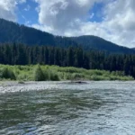
This heavy precipitation fuels the western river systems. These rivers carry massive volumes of water, sediment, and woody debris from the mountains down to the Pacific Ocean. Examples of these western rivers include the Hoh River, the Quinault River, and the Quillayute River. The constant flow of water erodes the mountain valleys, sharpening the topography and depositing rich alluvial soils in the lowlands. In winter, this precipitation falls as heavy snow at higher elevations, maintaining the park’s remaining 60 glaciers.
Conversely, after the air masses pass over the alpine peaks, they lose most of their moisture content. The air descends down the eastern slopes of the mountains, warming and compressing as it drops. This dry, descending air creates a rain shadow effect on the northeastern side of the peninsula. The town of Sequim, located just outside the northeastern park boundary, receives only about 16 inches of rain per year. This extreme variation from west to east occurs over a distance of fewer than 40 miles, resulting in completely different forest types, such as dry Douglas fir forests, on the eastern slopes.
What flora and fauna species live in the park?
Olympic National Park supports thousands of plant and animal species, including unique endemic organisms isolated by geography. The park acts as a critical biological stronghold for ancient old-growth trees, large terrestrial mammals, marine organisms, and threatened salmon populations.
The flora of the park is defined by its massive coniferous trees and thick epiphytic plants. Epiphytes are plants that grow non-parasitically on other plants, absorbing moisture and nutrients from the air. In the rainforests, club mosses, lichens, and ferns drape over the branches of bigleaf maple and sitka spruce trees. The forest floor is covered in a thick layer of decomposing organic matter. Fallen logs, known as nurse logs, provide essential nutrients, moisture, and elevated positions for new tree seedlings to grow, creating straight lines of mature trees over centuries.
The park protects dozens of mammal species across all three ecosystems. The Roosevelt elk is the largest herd-forming mammal in the park, migrating between high alpine meadows in summer and low rainforest valleys in winter. Other prominent mammals include black bears, cougars, black-tailed deer, and sea otters. The isolated geography of the Olympic Peninsula has also produced several endemic animal species. Examples of these unique animals include the Olympic marmot, the Olympic torrent salamander, and the Olympic Olympic grasshopper.
The aquatic and avian networks are equally complex. The park contains over 4,000 miles of pristine rivers and streams that support wild populations of native anadromous fish, which are fish that migrate from the ocean to freshwater to spawn. Examples include Chinook salmon, coho salmon, sockeye salmon, and steelhead trout. These fish provide vital marine nutrients to the terrestrial ecosystem when they die after spawning. The dense forests and coastlines also support threatened bird species, such as the northern spotted owl and the marbled murrelet.
What are the main geographic landmarks for visitors?
The main geographic landmarks for visitors are Hurricane Ridge, the Hoh Rainforest, Ruby Beach, and Lake Crescent. These strategic access points allow the public to experience the three primary ecosystems through developed roads, visitor centers, and managed trail networks.
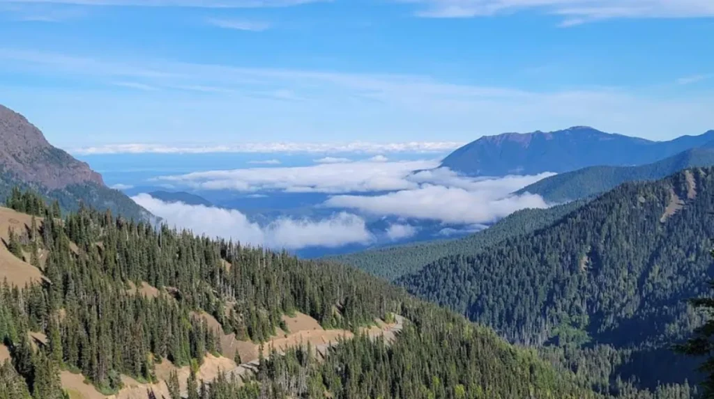
Hurricane Ridge is the premier alpine destination within the park, located 17 miles south of the coastal city of Port Angeles. Situated at an elevation of 5,242 feet, this ridge offers panoramic views of the interior Olympic range and the snow-capped peak of Mount Olympus. The region features a visitor center, paved viewing areas, and trails that access subalpine meadows. During the winter months, Hurricane Ridge receives an average of over 400 inches of snow, transforming the area into a managed winter sports zone.
The Hoh Rainforest is located on the western side of the peninsula, accessed via an upper valley road. This landmark features the Hoh Rain Forest Visitor Center and interpretive loops, such as the Hall of Mosses Trail and the Spruce Nature Trail. These trails guide visitors through old-growth forests dominated by sitka spruce trees draped in curtains of club moss. The Hoh River Trail also originates here, extending 17.4 miles along the river valley to the climbing base camps of Mount Olympus.
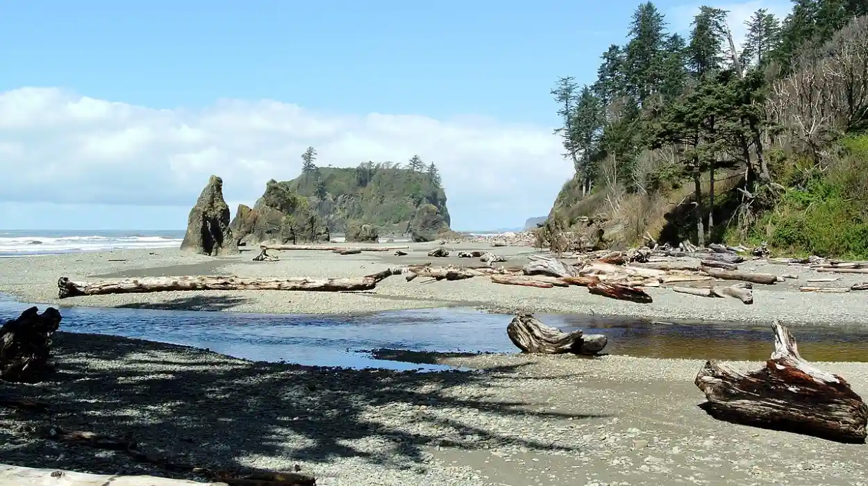
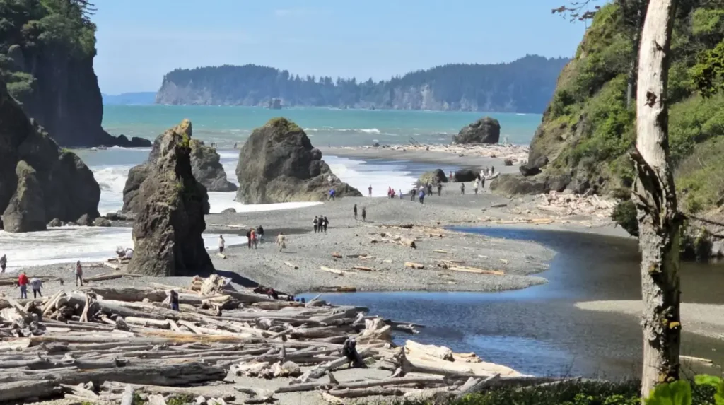
The coastal strip features several prominent landmarks, with Ruby Beach and Rialto Beach being the most accessible. Ruby Beach is famous for its dark sand, abundant marine driftwood, and massive sea stacks located just off the shoreline. Tide pools at nearby Kalaloch and Rialto Beach expose diverse marine colonies during low tide. Inland, Lake Crescent is a massive, glacially carved deepwater lake located in the northern region of the park. This lake features crystal-clear water with depth readings exceeding 600 feet, surrounded by steep mountain walls.
How does the park manage environmental conservation and restoration?
The park manages environmental conservation through targeted ecological restoration projects, invasive species eradication programs, and strict wilderness regulations. The most significant restoration success is the Elwha River Restoration Project, which removed two massive hydroelectric dams to restore native salmon populations.
The Elwha River Restoration Project represents the largest dam removal process in United States history. For nearly a century, the Elwha Dam and the Glines Canyon Dam blocked fish migration, trapped natural river sediments, and degraded the downstream aquatic habitat. The physical deconstruction of the dams took place between 2011 and 2014. Following the removal, scientists documented immediate environmental changes. Trapped gravels and sediments flowed downstream, rebuilding river banks and forming a new estuary at the mouth of the river, which created essential spawning habitats.
Wild salmon species returned to their ancestral spawning grounds above the historic dam sites within months of the river clearing. The National Park Service monitors these populations using sonar technology, electronic tagging, and spawning ground surveys. This project serves as a premier international model for river restoration science. In addition to river management, park biologists work to eradicate invasive non-native species that threaten native biodiversity. Examples of destructive invasive species include knotweed plants, reed canary grass, and non-native mountain goats, which were relocated to the Cascade Mountains.
The park also utilizes strict human management protocols to minimize environmental degradation. The wilderness reservation system requires backcountry hikers to obtain specific permits, carry wildlife-resistant food canisters, and follow Leave No Trace principles. Human waste management is strictly controlled in high-use alpine zones to protect fragile heather communities. Park engineers are also adapting infrastructure to survive the effects of climate change, such as rising sea levels along coastal roads and melting glaciers that alter summer stream flows.
What are the economic and future impacts of the park?
The economic and future impacts of the park involve generating millions of dollars in regional tourism revenue and serving as a critical global baseline for climate change research. As glaciers recede rapidly, the park provides vital data on alpine ecosystem transitions.
Economic analyses conducted by the National Park Service show that visitor spending generates over 270 million dollars in direct economic output for the surrounding gateway communities annually. This economic activity supports over 2,500 local jobs in sectors such as lodging, food service, transport, and recreation guides. The towns of Port Angeles, Forks, and Sequim rely heavily on this predictable seasonal tourism influx. The park also maintains vital historic partnerships with local tribal enterprises and state tourism agencies to balance preservation with regional economic development.
Future environmental challenges center heavily on global climate change. Scientific measurements indicate that the park’s glaciers are receding rapidly, with some predicted to disappear completely within the next few decades. The loss of these permanent ice reservoirs alters the hydrological cycle of the entire peninsula. Glacial meltwater provides a steady flow of cold water to alpine streams during dry late-summer months. Without this ice melt, water temperatures will rise, which threatens the survival of temperature-sensitive salmon species and changes the distribution of subalpine plants.
Consequently, Olympic National Park has become a vital living laboratory for international climate scientists. Ongoing research initiatives track changes in forest growth patterns, shifts in animal migration timelines, and the acidification of coastal tide pools. By protecting a continuous, unbroken line of wilderness stretching from the ocean to the mountains, the park allows flora and fauna to shift their geographic ranges naturally as temperatures warm. Preserving this intact landscape ensures that Olympic National Park will continue to function as a resilient ecological refuge for centuries to come.
What is Olympic National Park known for?
Olympic National Park is known for protecting three major ecosystems: temperate rainforests, rugged Pacific coastline, and glaciated alpine mountains. The park also contains old-growth forests, sea stacks, glaciers, and over 95% federally protected wilderness.