Orcas Island Guide Washington offers the definitive map to the San Juan Islands’ crown jewel, featuring Mount Constitution’s 2,409-foot summit with 360-degree views, 38 miles of Moran State Park trails, and Turtleback Mountain’s dramatic overlooks. Visitors reach this 17-square-mile island via the 90-minute Washington State Ferry from Anacortes, then explore old-growth forests, lake loops, saltwater beaches, and the historic 1936 CCC watchtower that defines Washington’s premier island hiking destination.
- What is Orcas Island and why is it called the crown jewel of the San Juan Islands?
- How do visitors reach Orcas Island and what transportation options exist?
- What are the best hiking trails on Orcas Island for scenic views?
- Which trails are best for families and beginners on Orcas Island?
- What waterfalls, lakes, and natural features can hikers find in Moran State Park?
- When is the best time to visit Orcas Island for whale watching and outdoor activities?
- Where should visitors eat and stay in Eastsound and other Orcas Island communities?
- What marine activities like sea kayaking, whale watching, and fishing exist on Orcas Island?
- Why is Mount Constitution the highest point in the San Juan Islands and what views does it offer?
What is Orcas Island and why is it called the crown jewel of the San Juan Islands?
Orcas Island is a 17-square-mile island in Washington’s San Juan Islands, nicknamed the crown jewel for its dramatic elevation, 38 miles of hiking trails, old-growth forests, and panoramic Salish Sea views. The island hosts 4,900 residents across Orcas Village, Eastsound, Deer Harbor, and Rosario, with Mount Constitution marking the San Juan Islands’ highest point at 2,409 feet.
Orcas Island sits 15 miles northwest of Anacortes in Puget Sound, part of San Juan County, Washington. The island measures nearly 7 miles long and 3 miles wide, covering approximately 17 square miles of forested terrain rising to Mount Constitution’s summit. This elevation creates the island’s most dramatic feature: unprecedented vista points showing Vancouver Island, the Olympic Mountains, Mt. Baker, and Mt. Rainier when weather permits.
The San Juan Islands contain 450+ islands in the Salish Sea, but Orcas stands alone with its combination of high elevation, extensive trail network, and accessible old-growth forest. Moran State Park occupies 5,200 acres on the island’s east side, encompassing five lakes, multiple waterfalls, and the majority of the 38-mile trail system.
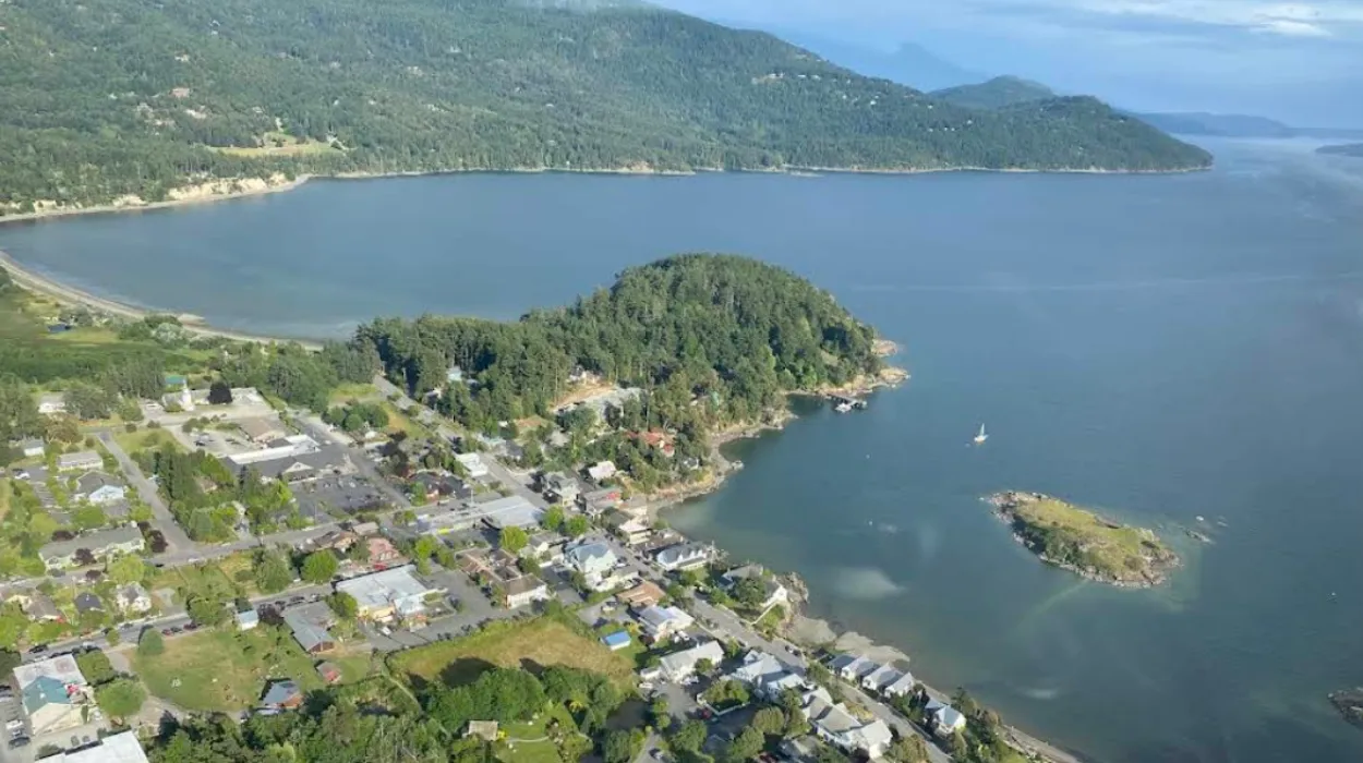
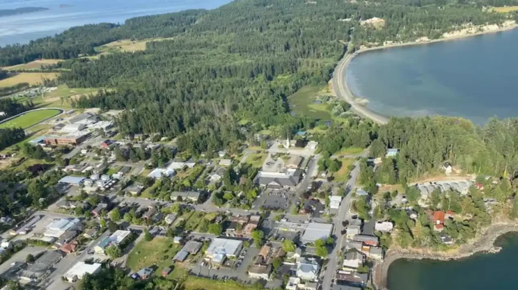
Six communities define island life: Orcas Village (ferry landing), Eastsound (main town with galleries, restaurants, and boutiques), Deer Harbor (working fishing harbor), Rosario (resort village), Elephant Harbor, and Crow Valley (rural residential). Eastsound serves as the commercial center along North Beach Road and Main Street, featuring Brown Bear Baking, The Lower Tavern burger pub, and 12+ restaurants.
The island’s population reached approximately 4,900 residents per San Juan County records, with the Orcas Island School District serving 5,882 people in 2024. Tourism spikes during summer months when ferry traffic increases and whale watching season peaks.
Orcas Island Airport receives flights from Anacortes and Seattle, providing air access alongside the dominant ferry route. The Washington State Ferry operates daily from 7:05 AM to 10:45 PM, with-frequency ranging 85-230 minutes depending on day.
How do visitors reach Orcas Island and what transportation options exist?
Visitors reach Orcas Island primarily via the 90-minute Washington State Ferry from Anacortes, which runs daily 7:05 AM–10:45 PM with 85–230 minute frequency and allows cars. Alternative options include Orcas Island Airport (flights from Seattle/Anacortes) and private boats docking at Eastsound or Deer Harbor marinas.
The Washington State Ferry represents the most common access method, departing Anacortes Terminal and arriving at Orcas Village ferry landing. The 90-minute crossing reveals remote island scenery across Massacre Bay. Car transport is recommended since the island’s spread-out geography makes walking impractical for most visitors.
Ferry schedules operate consistently across all days: Monday through Sunday services begin at 7:05 AM and end at 10:45 PM. Frequency varies by day—Monday, Thursday, Friday, and Saturday show 85–185 minute intervals; Tuesday, Wednesday, and Sunday show 92–230 minute intervals. First ferry to Anacortes departs Orcas Island at 6:45 AM; last ferry from Anacortes leaves at 10:05 PM, arriving 10:55 PM.
Fare information requires checking current Washington State Ferries pricing, as rates change seasonally. Car transport adds significant cost compared to passenger-only fares. Weekend and summer schedules often increase frequency to handle tourist volume.
Orcas Island Airport (KORC) provides air access with flights from Seattle and Anacortes. This option serves travelers seeking time efficiency over ferry scenery. The airport handles small aircraft and connects to regional aviation networks.
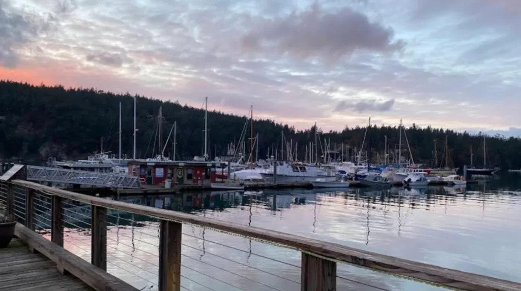
Private boat access occurs through multiple marinas: Eastsound Marina (main town), Deer Harbor Marina (working fishing harbor), and Rosario Marina (resort). These facilities offer docking, fuel, and marine services. Sea kayak tours depart from Rosario Marina during summer months via Outer Island Excursions.
Once on island, transportation options include rental cars (available at ferry terminal), bicycles (popular for Eastsound-area exploration), walking (limited to town centers), and private shuttles. The island lacks public transit, making personal vehicles essential for trail access. Most hiking trailheads require driving 10–20 minutes from Orcas Village.
GPS navigation works reliably across the island, though cellular service gaps exist in rural areas. Offline map downloads recommended before exploring Moran State Park or Turtleback Mountain Preserve.
What are the best hiking trails on Orcas Island for scenic views?
The best scenic trails include Mount Constitution Loop (7 miles, 2,409-ft summit with 360-degree views), Turtleback Mountain’s Ship Peak Trail (2.9 miles, 860-ft ascent with panoramic island views), and Turtlehead Overlook (1.2 miles to jaw-dropping south-facing vista over Massacre Bay and Olympic Mountains).
Mount Constitution represents the island’s crown-trail experience. The Mount Constitution Loop spans nearly 7 miles, delivering dramatic vista points throughout. Elevation gain reaches 1,640–1,700 feet depending on starting point. The summit at 2,409 feet marks the San Juan Islands’ highest point, offering 360-degree views of San Juan Islands, Vancouver Island, mainland Washington, Mt. Baker, and Mt. Rainier.
The Civilian Conservation Corps built the hand-cut stone watchtower in 1936, adding historical significance to the mathematical view geometry. From this tower, visitors see snow-tipped peaks bracketing island clusters across the Salish Sea. Weather clarity determines visibility range, with perfect days showing 100+ mile distances.
Trail access begins at Mountain Lake parking lot (900-ft elevation, halfway up Mount Constitution). The paved road reaches the summit, allowing vehicle access for those avoiding hiking. Hiking from Mountain Lake follows cool old-growth forest shade transitioning to sunny alpine meadows with wildflowers.
Turtleback Mountain Preserve on the island’s west side offers 8.7 miles of trails across two trailheads. The North Trailhead sits on Crow Valley Road; the South Trailhead locates off Deer Harbor Road. An 8-mile network connects both trailheads, plus a 1-mile trail to Turtlehead’s jaw-dropping vista.
Ship Peak Trail from the south trailhead spans 2.9 miles, ascending 860 feet through open grassy hillsides and Garry oak forests. After 1.2 miles, the West Overlook bench provides spectacular south-west viewing. Continue 0.3 miles to Ship Peak Overlook for panoramic photography opportunities. Total round trip from south trailhead measures 2.5 miles; from north trailhead it reaches 5.4 miles.
North Valley Overlook (0.5 miles, 15-minute moderately steep stroll) and Walden Overlook (1.5 miles) serve north trailhead visitors. West Overlook (1 mile from south trailhead) and Ship Peak (3 miles total) serve south trailhead users. These overlooks show Crow Valley, Massacre Bay dotted with islands, and distant Olympic Mountains.
Turtlehead Preserve’s 1-mile trail delivers the preserve’s highest vista, looking south over Massacre Bay with island clusters and Olympic Mountains in the distance. This out-and-back trail totals 6 miles round trip from the north parking lot.
Cascade Lake Loop (2.9 miles) offers easier hiking with lake views, kokanee salmon stream crossings, and a wooden bridge over the lagoon where locals swim and picnic. The trail’s highest point features a twisted fir tree reigning over water.
Mountain Lake Loop (4 miles paved) provides leisurely walking around the lake at 900-ft elevation. Visitors can swim, dock-side dangle feet, or camp at lakeside sites. The trail passes Western Red Cedar, Douglas fir, salmonberries, salal berries, ferns, and endless moss varieties.
Obstruction Pass State Park at the southeastern tip offers 80 acres with two under-mile trails. The easterly trail reaches a 150-yard triangular-rock beach with Lopez Island, Blakely Island, and Obstruction Island views. The westerly trail ends at panoramic water views and picnic sites.
Which trails are best for families and beginners on Orcas Island?
Family-friendly beginner trails include Cascade Lake Loop (2.9 miles, easy, lake views with swim opportunities), Mountain Lake Loop (4 miles, paved, gentle slope, swimming dock), and Obstruction Pass State Park trails (both under 1 mile, beach access, panoramic views).
Cascade Lake Loop represents the easiest rewarding hike on Orcas Island. The 2.9-mile counterclockwise loop crosses a stream where landlocked kokanee salmon migrate upstream to Moran Creek hatchery in fall. The trail’s highest point offers twisted fir tree viewing over water. Halfway through, a wooden bridge provides lagoon views where locals swim and picnic with rowboats.
The trail remains wide and soft, padded with forest duff. Gentle slopes dominate most of the loop, making it suitable for children and novice hikers. The two-hour outing includes dock time for foot-dangling or cooling dives in clear water. Campsites along the lake allow sunrise bird-song waking with placid water views.
Mountain Lake Loop’s paved road accessibility makes it ideal for families. The 4-mile counter-clockwise stroll starts at Mountain Lake parking lot (900-ft elevation). Wide soft paths with gentle slopes pass Western Red Cedar, Douglas fir, salmonberries, salal, ferns, and moss varieties. The weir (concrete waterfall) and felled trees provide natural obstacles for children to navigate.
The lake’s dock enables family swimming breaks. Several campsites allow multi-day family camping experiences. The perfect two-hour length accommodates young hikers’ energy limits while delivering satisfying forest exploration.
Obstruction Pass State Park’s two trails both run under 1 mile through lush vegetation and forest. The 150-yard triangular-rock beach on the easterly trail offers unique island geology viewing. Panoramic water views at the westerly trail’s end create perfect picnic locations. The 80-acre parkland with 10 campsites supports family camping.
Turtleback Mountain’s North Valley Overlook (0.5 miles, 15-minute moderately steep stroll) provides quick family achievement. Walden Overlook (1.5 miles) and West Overlook (1 mile from south trailhead) offer manageable distances with substantial view rewards. These overlooks show Crow Valley, Massacre Bay islands, and Olympic Mountains without demanding peak ascents.
Explore More Things to do
Friday Harbor Travel Guide: Best Things to Do in San Juan Island Washington
San Juan Islands Washington Whale Watching Guide: Best Trips, Tours & Tips
What waterfalls, lakes, and natural features can hikers find in Moran State Park?
Moran State Park contains 5,200 acres with five lakes (Mountain Lake, Cascade Lake, Summit Lake, Twin Lakes, and unknown fifth), multiple waterfalls including Cascade Falls, and 38 miles of trails through old-growth forest. The park’s elevation spans 900–2,409 feet, creating forest-to-alpine meadow transitions.
Mountain Lake sits at 900-ft elevation halfway up Mount Constitution, accessible via paved road. The lake features a swimming dock, campsites, and a 4-mile loop trail. A weir (concrete waterfall) crosses the trail, providing small waterfall viewing. The lake’s lagoon serves local swimming and rowboat picnicking.
Cascade Lake occupies lower elevation with the 2.9-mile loop trail. Landlocked kokanee salmon migrate upstream from Cascade Lake to Moran Creek hatchery in fall, crossing the trail’s stream. The lake’s lagoon behind the wooden bridge enables swimming and picnic activities.
Summit Lake located near Mount Constitution’s upper reaches passes during the summit hike. The trail passes the outlet before continuing along the ridge to the top.
Twin Lakes connect via trails beyond Mountain Lake, offering additional hiking destinations. Cascade Falls represents the park’s primary waterfall destination, accessible from Mountain Lake trail extensions.
Old-growth forest serves as the protective canopy throughout the park, featuring Western Red Cedar, Douglas fir, salmonberries, salal berries, ferns, and endless moss varieties. The forest transitions from cool shade to sunny alpine meadows with wildflowers as elevation increases toward Mount Constitution.
The park’s 38-mile trail network encompasses varied difficulty levels, nearly all featuring fantastic views or unique surroundings. Trails lead around lakes, waterfalls, and through old-growth forest. Every fitness level finds suitable options within the 5,200-acre wilderness.
When is the best time to visit Orcas Island for whale watching and outdoor activities?
May through September represents peak whale watching season with 90%+ success rates from local companies. Summer months offer optimal hiking conditions, ferry frequency increases, sea kayak tours operate from Rosario Marina, and all trails remain accessible. Spring brings wildflower-covered slopes at Turtleback Mountain.
Whale watching peaks May through September when local companies report 90%+ viewing success rates. Outer Island Expeditions offers daily 3–4 hour kayaking adventures through Orcas Island waters starting at $119 per adult. This season aligns with optimal weather, clear visibility, and active marine mammal populations.
Summer ferry schedules increase frequency to handle tourist volume. The regular 7:05 AM–10:45 PM operating window maintains consistent daily service, but summer weeks often add extra crossings. Car transport availability improves during peak season.
Sea kayak tours depart Rosario Marina during summer months via Outer Island Excursions. These tours explore saltwater channels, island clusters, and coastal features inaccessible by foot. Rental equipment available on Orcas Island supports independent kayaking.
Spring brings wildflower-covered slopes at Turtleback Mountain’s South Trail. The stream crossing and winding ascent create colorful spring hiking experiences. Garry oak forests and open grassy hillsides bloom during March–May.
Fall features kokanee salmon migration from Cascade Lake to Moran Creek hatchery. The 2.9-mile Cascade Lake Loop crosses the migration stream, offering wildlife viewing opportunities. Fall weather remains suitable for hiking through October.
Winter months see reduced ferry frequency (92–230 minute intervals on Tuesday–Sunday) and limited tourist services. Some restaurants and tours close seasonally. However, winter hiking offers solitude, dramatic storm viewing from Mount Constitution, and no trail crowding.
最佳 hiking weather occurs June–September with average temperatures 65–75°F, minimal rain, and clear summit visibility. July and August represent peak tourist months with highest ferry crowding but最佳 whale watching conditions.
Where should visitors eat and stay in Eastsound and other Orcas Island communities?
Eastsound features 12+ restaurants including Brown Bear Baking (decadent pastries, bear claws, 8AM–4PM), The Lower Tavern (best burger pub, 46 Prune Alley), Mijitas (Mexican), La Madrona Bar and Grill (seafood/steak), and Enzo’s (early-opening coffee). Accommodations include inns, B&Bs, resorts, and Doebay Resort (romantic outdoor hotspring).
Brown Bear Baking at 29 North Beach Road (at Main St) operates Friday–Monday 8AM–4PM, offering decadent sweet and savory pastries from classically-trained bakers. The bear claws generate island-wide lineups starting one hour before opening. Contact: 360-855-7456, info@brownbearbaking.com.
The Lower Tavern at 46 Prune Alley holds bragging rights for the island’s best burger. Beyond pub dining, this establishment serves as a multi-purpose venue. Contact: 360-376-4848.
Mijitas represents the Mexican food bright spot, maintaining July 4th openings when other restaurants close. La Madrona Bar and Grill serves seafood and steak dinners with indoor and in-season outdoor waterfront dining. Both restaurants accommodate families, though La Madrona lacks vegan options.
Enzo’s opens early for morning coffee, serving Batdorf & Bronson coffee with East Sound waterfront views. The Lower Tavern and resort restaurants provide bar dining options. East Sound’s waterfront stretch features multiple restaurants with varying price points.
High-class island dining occurs at resort restaurants in Eastsound, Deer Harbor, and Rosario. These venues offer seafood and steak dinners with indoor dining plus in-season outdoor waterfront views. All resorts provide year-round indoor service.
Accommodation options span hotels, B&Bs, resorts, and campsites. Doebay Resort offers romantic outdoor experiences with zen hotsprings and beautiful views. The island features camping facilities, hiking access, boating, whale watching, and fishing opportunities.
Moran State Park contains several campsites along Mountain Lake, enabling sunrise bird-song waking with placid water views. Obstruction Pass State Park offers 10 campsites within 80 acres. These locations support multi-day hiking adventures.
Eastsound’s North Beach Road and Main Street waterfront stretch features galleries, souvenir stores, and boutique shops. Prune Alley mixes restaurants with utilitarian retail and services. The town’s peaceful, scenic character with abundant nature creates cute downtown exploration.
Deer Harbor functions as a working fishing harbor with marina access. Rosario operates as a resort village with marina-based sea kayak tours. These communities offer quieter alternatives to Eastsound’s commercial center.
What marine activities like sea kayaking, whale watching, and fishing exist on Orcas Island?
Marine activities include whale watching (90%+ success May–September), sea kayaking via Outer Island Expeditions ($119+/adult, 3–4 hours, daily summer tours from Rosario Marina), and fishing at Deer Harbor working harbor. Rental equipment available on island supports independent kayaking.
Whale watching operates May through September with local companies reporting 90%+ viewing success rates. Outer Island Expeditions provides daily 3–4 hour kayaking adventures through Orcas Island waters, starting at $119 per adult. This activity combines marine mammal viewing with active paddling through Salish Sea channels.
Sea kayak tours depart Rosario Marina during summer months via Outer Island Excursions. These tours explore saltwater channels, island clusters, and coastal features inaccessible by foot. The Rosario Marina serves as the primary tour departure point for organized marine adventures.
Fishing opportunities center on Deer Harbor’s working fishing harbor. The marina provides boat access, fishing gear, and local knowledge for saltwater fishing. Orcas Island supports fishing as a primary outdoor activity alongside hiking, boating, and whale watching.
Rental equipment available on Orcas Island enables independent kayaking exploration. Visitors can rent kayaks for self-guided Salish Sea exploration without booking organized tours. This option suits experienced paddlers seeking flexible schedules.
Massacre Bay, visible from Turtleback Mountain’s overlooks, dotted with islands and the Olympic Mountains in the distance, serves as a marine activity zone. The bay’s island clusters create natural channels for kayaking and whale watching.
Saltwater beaches include Obstruction Pass State Park’s 150-yard triangular-rock beach, unique in the islands with Lopez Island, Blakely Island, and Obstruction Island views. This beach enables shoreline exploration and marine feature viewing.
The Salish Sea’s 450+ island network provides endless marine exploration opportunities. Orcas Island’s position within this network creates ideal access points for multi-day marine adventures combining kayaking, whale watching, and island hopping.
Why is Mount Constitution the highest point in the San Juan Islands and what views does it offer?
Mount Constitution reaches 2,409 feet, making it the San Juan Islands’ highest point. The summit delivers 360-degree views of San Juan Islands, Vancouver Island, mainland Washington, snow-tipped Mt. Baker, and Mt. Rainier. The 1936 Civilian Conservation Corps stone watchtower adds historical significance.
The 2,409-foot elevation creates the island’s defining geographic feature. This height exceeds all other San Juan Islands by 400+ feet, establishing unmatched viewing geometry. The elevation gain from Mountain Lake (900 ft) reaches 1,640–1,700 feet depending on trail start.
360-degree views encompass the entire San Juan Islands cluster, Vancouver Island across the Strait of Juan de Fuca, mainland Washington’s Olympic Peninsula, and the Cascade Range’s snow-tipped giants. Mt. Baker and Mt. Rainier bracket the island view when weather permits. Perfect visibility days show 100+ mile distances.
The Civilian Conservation Corps built the hand-cut stone watchtower in 1936, adding historical interest to the mathematical view geometry. This structure represents Depression-era public works infrastructure, still functioning as the primary summit viewing platform.
Trail access begins at Mountain Lake parking lot (900-ft elevation, halfway up). The paved road reaches the summit, allowing vehicle access for non-hikers. Hiking follows cool old-growth forest shade transitioning to sunny alpine meadows with wildflowers.
The Mount Constitution Loop spans nearly 7 miles, delivering dramatic vista points throughout the ascent. This trail is not rushed, as old-growth forest appreciation and wildflower meadow transitions create multiple stopping opportunities.
Summit Lake’s outlet passes during the climb before continuing along the ridge to the top. The trail’s forest-to-alpine transition demonstrates elevation-driven ecological changes.
Weather clarity determines visibility range, with perfect days showing comprehensive island clusters, mountain ranges, and water bodies. Summer months (June–September) offer the clearest summit views with minimal rain and average 65–75°F temperatures.
The summit’s elevation creates temperature differences from island base areas, often requiring layered clothing. Wind conditions intensify at 2,409 feet, making the watchtower essential for sheltered viewing.
What is Orcas Island known for?
Orcas Island is known as the crown jewel of Washington’s San Juan Islands because of its dramatic mountain scenery, old-growth forests, scenic lakes, and the highest point in the archipelago, Mount Constitution. The island is also popular for hiking, whale watching, kayaking, and charming villages such as Eastsound.