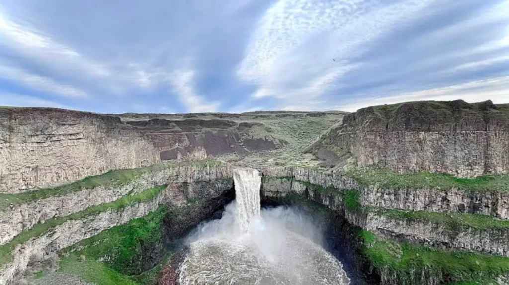
Palouse Falls State Park is Washington’s official state waterfall and one of the state’s most distinctive natural landmarks. It sits in southeast Washington, where the Palouse River drops about 198 feet into a basalt canyon formed by Ice Age floods, creating a dramatic desert-waterfall landscape.
- What is Palouse Falls State Park?
- Why is Palouse Falls historically important?
- What can visitors do at Palouse Falls State Park?
- Are the base trails open at Palouse Falls?
- When is the best time to visit Palouse Falls?
- What should visitors know about safety?
- How was Palouse Falls formed?
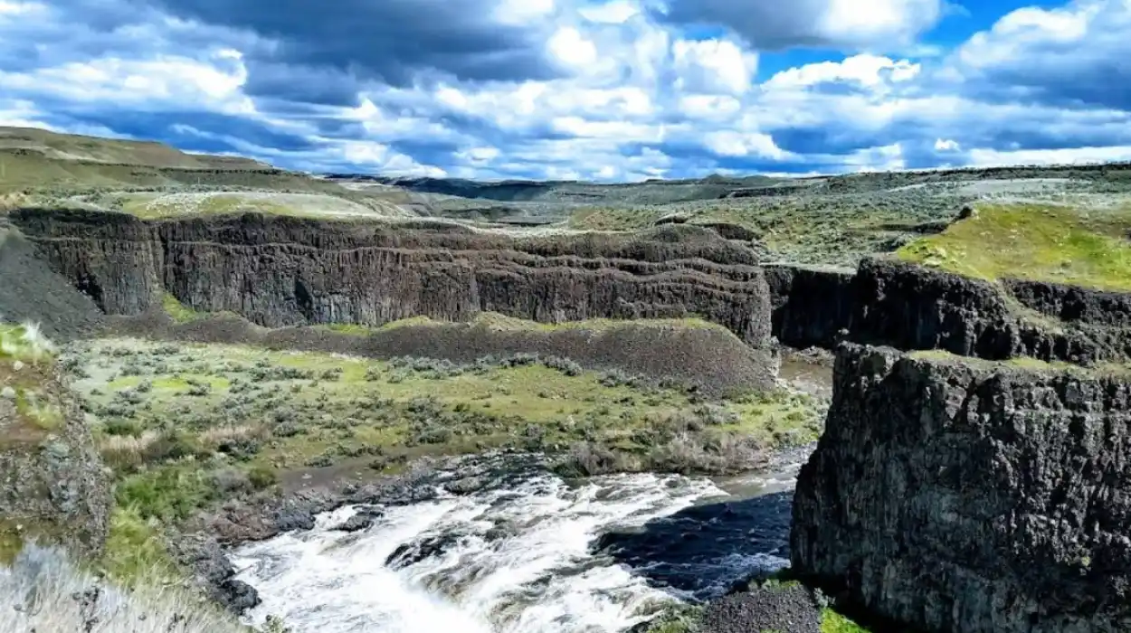
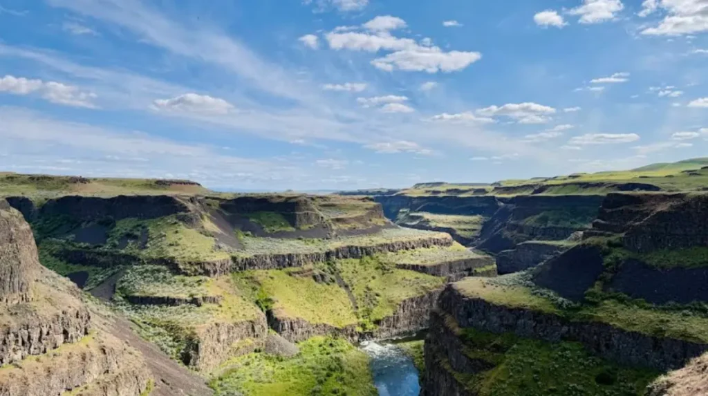
- What does the landscape around the falls look like?
- How does Palouse Falls fit into Washington travel?
- What are the most useful visitor facts?
- Why does Palouse Falls remain a hidden gem?
What is Palouse Falls State Park?
Palouse Falls State Park is a 94-acre Washington state park centered on a 198-foot waterfall in a basalt canyon, with overlooks, picnic areas, and limited day-use and camping access. It is best known for its official-state-waterfall status and its exposed Ice Age geology.
The park protects a compact but highly scenic area in southeastern Washington. The waterfall, also called Aput Aput, sits on the Palouse River upstream from its confluence with the Snake River. Washington Trails Association notes that the falls are the state’s official waterfall and that the surrounding landscape is a remnant of the Missoula Floods, the series of glacial outburst floods that shaped much of eastern Washington.
The park’s appeal comes from contrast. Dry grassland and basalt cliffs frame a large, powerful waterfall in a region better known for open steppe than for heavy water features. That contrast makes the site visually memorable and geographically important.
Why is Palouse Falls historically important?
Palouse Falls is historically important because it is tied to Indigenous naming, Ice Age flood geology, and Washington’s formal recognition of the site as the state waterfall in 2014. These layers give the park cultural, scientific, and symbolic value.
The name Aput Aput is associated with the Palouse people and means “Falling Water,” according to Washington Trails Association. That connection places the falls within a longer Indigenous history of the region rather than only a modern recreation context.
Geologically, Palouse Falls stands out because it marks one of the last major waterfalls along the route carved by the Missoula Floods at the end of the last ice age. Those floods reshaped eastern Washington into the scablands, producing coulees, cliffs, and flood channels visible across the region.
The state’s formal recognition of Palouse Falls as Washington’s official state waterfall on February 12, 2014, also matters for public identity and tourism. It positioned the site as a signature landmark for the state rather than just a local scenic stop.
What can visitors do at Palouse Falls State Park?
Visitors can view the waterfall from overlooks, walk short gravel paths, picnic at sheltered or unsheltered tables, and camp in designated areas. The park focuses on scenic viewing rather than long trail networks or strenuous recreation.
The main visitor experience is the overlook near the parking area. Washington Trails Association describes a graveled path of about one-third of a mile that loops around the grassland and returns to the parking area. That route gives most visitors an easy way to reach viewpoints without a long hike.
The park also includes picnic facilities, information kiosks, and pit toilets. These basic amenities support day trips and simple overnight stays, but the park remains relatively undeveloped compared with larger recreation areas in Washington.
Camping exists, but the park is still primarily a day-use destination. RVezy describes it as a 94-acre day-use and tent-camping park, which reflects its small footprint and limited infrastructure.
Are the base trails open at Palouse Falls?
No. The park permanently closed the trails leading to the canyon base in early 2022 because of repeated accidents and injuries on steep, unstable social trails. Visitors now stay on designated viewing routes and overlooks.
This is one of the most important planning facts for anyone searching the park. Washington Trails Association explains that user-created bootpaths were closed in late 2015 after misuse and injuries, briefly reopened with safety signage, and then permanently closed in early 2022.
The closure changed how visitors experience the falls. The standard visit now centers on elevated viewpoints rather than canyon-floor access, which makes safety and route expectations clearer for first-time visitors.
The practical result is simple: plan for a scenic overlook visit, not a descent to the base of the waterfall. That distinction matters for trip timing, footwear choice, and activity planning.
When is the best time to visit Palouse Falls?
The best time to visit Palouse Falls is late in the day, especially around sunset, because the canyon light improves and the falls are seen with better shadow and color contrast. Morning is quieter, but the sun can be harsh and directly in your eyes.
Washington Trails Association specifically recommends timing a visit with sunset for the best visual experience. The changing light along the canyon walls creates stronger contrast and a more dramatic view of the waterfall.
TripAdvisor visitor feedback also points to late afternoon as a strong choice, with one response noting that around 4 p.m. through sunset places the sun behind the viewer. That same source notes that mornings are less crowded, though the viewing angle is less favorable then.
Seasonality matters as well. The region is dry and exposed, with limited shade, so hotter months require extra water, sun protection, and careful timing. The best overall visit often combines cooler temperatures with lower sun angles in the late afternoon.
What should visitors know about safety?
Visitors should know that Palouse Falls is scenic but exposed, with rattlesnakes, loose rocks, steep drop-offs, and strong sun as the main hazards. The safest visit stays on marked paths and viewing areas.
Washington Trails Association warns that rattlesnakes live in the area and that visitors should watch where they step. The same source also notes that the old dirt path into the canyon is steep, loose, and hazardous, which is why the park discourages use of those social trails.
The landscape offers little shade, so heat and dehydration also matter. This is especially relevant during warmer months, when open grassland and basalt terrain reflect heat and provide limited cover.
Good footwear, water, and awareness of boundaries are essential. The park’s appeal depends on rugged terrain, but the safest experience comes from respecting the designed viewpoints rather than treating the area like a full hiking destination.
How was Palouse Falls formed?
Palouse Falls was formed by Ice Age flood geology, when repeated Missoula Floods scoured eastern Washington and carved the basalt canyon that now holds the waterfall. The site remains one of the clearest examples of that landscape.
The key process is catastrophic flooding. At the end of the last ice age, massive glacial outburst floods moved across the region, cutting deep channels and leaving behind the scablands terrain. Palouse Falls survived as a major waterfall on that flood-carved route.
The surrounding canyon walls are basalt, which gives the falls its dramatic black-rock backdrop. That geology is part of why the site looks so different from wooded or mountain waterfalls elsewhere in Washington.
This geologic story gives the park educational value beyond recreation. Visitors are seeing not just a waterfall, but a visible record of a major landscape-forming event in North American natural history.
What does the landscape around the falls look like?
The landscape around Palouse Falls combines basalt cliffs, grassland, desert-steppe vegetation, and a narrow river corridor. That mix creates a high-contrast setting that feels unlike western Washington waterfalls.
Washington Trails Association describes the route as passing through grassland with wildflowers in season, along with views of the canyon and waterfall. The area is open enough that the horizon and cliff edges become part of the visitor experience.
The region also supports wildlife adapted to dry terrain. The same source mentions yellow-bellied marmots and rattlesnakes, both of which fit the park’s rocky, open environment.
This setting matters for photography and trip planning. The open terrain gives broad views, but it also means strong sun, limited shade, and fewer sheltered walking options than in forested parks.
How does Palouse Falls fit into Washington travel?
Palouse Falls fits into Washington travel as a signature southeastern Washington stop that pairs well with regional road trips, geology-focused travel, and scenic landscape photography. It is a compact destination with high visual payoff.
Because the park is relatively small and focused, it works best as a half-day stop rather than a full itinerary anchor. That makes it useful for travelers exploring eastern Washington, the Palouse region, or routes linking inland scenic areas.
The site also has strong branding value for Washington tourism because it combines an official designation, a memorable visual identity, and a clear natural story. Those are the kinds of attributes that help a destination stand out in search results and on social platforms.
For content readers, the park also satisfies multiple intent types at once: scenic travel, natural history, state-park planning, and photography. That broad relevance helps explain why the site appears in hiking, camping, and general destination searches.
Explore More Things to do
Earthquake in Venezuela: Causes, Impact, Response, and Safety Guide
Spokane Winter Travel Guide: Things to Do in Washington State
What are the most useful visitor facts?
The most useful facts are simple: the park is 94 acres, the falls drop 198 feet, the official waterfall designation dates to 2014, and the canyon-base trails are closed. These facts define the modern visitor experience.
The 94-acre size tells visitors to expect a small park with limited facilities rather than a large multi-day recreation area. The 198-foot drop explains why the waterfall feels so dramatic even from a viewing area.
The 2014 designation gives the site official state-level recognition, while the 2022 trail closure tells visitors to plan around overlooks, not canyon access. Those two dates are especially useful for evergreen planning content because they define the current park identity.
The park is also notable for being both accessible and rugged. That combination makes it one of Washington’s most efficient scenic stops: short visit, strong payoff, clear geography, and a memorable story.
Why does Palouse Falls remain a hidden gem?
Palouse Falls remains a hidden gem because it sits off the main tourist corridor, offers a dramatic official state waterfall, and delivers a strong scenic experience with limited crowds compared with Washington’s better-known destinations.
Its location in southeastern Washington keeps it outside the state’s most heavily trafficked mountain and coast tourism routes. That relative isolation preserves its reputation as a lesser-known landmark even though it is formally recognized and widely photographed.
The park also has a very specific visitor profile. People come for the overlook, the geology, and the iconic view, then leave after a short stay. That pattern keeps the destination efficient but still somewhat under the radar.
For evergreen travel content, that combination is ideal. It is a destination with clear identity, factual depth, and durable search interest across travel, state parks, geology, and Washington road-trip topics.
Palouse Falls State Park is one of Washington’s most distinctive natural sites because it combines an official state designation, visible Ice Age geology, and a dramatic 198-foot waterfall in a compact park setting. Visitors get the best experience from overlooks, late-day light, and careful attention to safety and trail closures.
Where is Palouse Falls State Park located?
Palouse Falls State Park is located in southeastern Washington along the Palouse River, upstream from its confluence with the Snake River. The 94-acre state park is known for its dramatic basalt canyon and Washington’s official state waterfall.