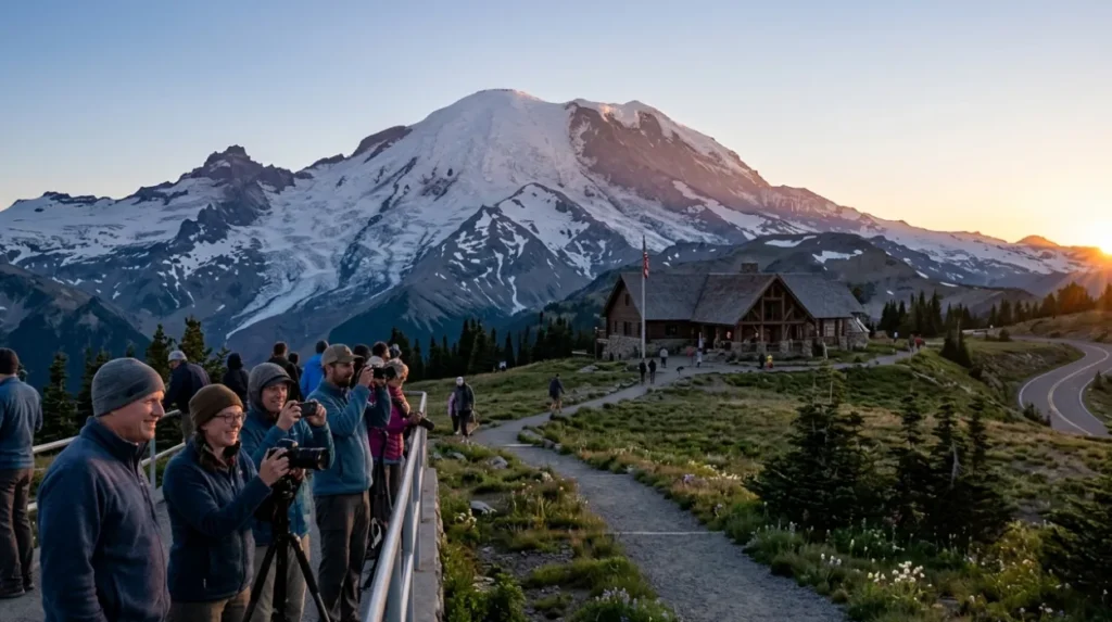
Mount Rainier’s Sunrise area is the highest point visitors can drive to in the park, sitting at 6,400 feet on the mountain’s northeast side, with summer-only access and wide views of glaciers, meadows, and the Cascade Range. The best scenic spots are Sunrise Point, the visitor centre area, and nearby trail viewpoints such as Sourdough Ridge and Dege Peak, because they combine clear sightlines, high elevation, and strong sunrise light.
- What is Sunrise at Mount Rainier?
- Why does Sunrise get clear light?
- Where are the best scenic spots?
- Which viewpoints suit photography?
- Which hikes reach sunrise views?
- What is the historical context?
- When is the best time to go?
- How do road access and permits work?
- What should visitors expect on site?
- Why does Sunrise matter in Washington?
What is Sunrise at Mount Rainier?
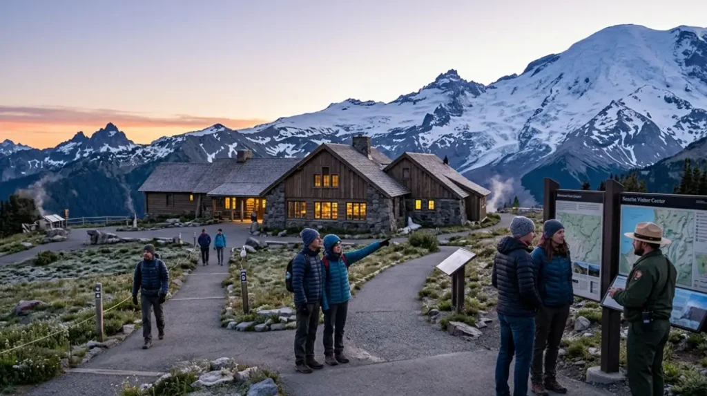
Sunrise is Mount Rainier National Park’s high-elevation northeast area, open in summer, where visitors reach broad alpine and subalpine views by road and short hikes. It includes the Sunrise Visitor Center, Sunrise Point, trails, historic structures, and meadow landscapes shaped by volcanic geology and seasonal snow.
Sunrise sits in the park’s drier northeastern corner, which gives it clearer morning views than many wetter locations on the west side of the mountain. The area is open only in summer, typically from early July to late September, with timed-entry reservations required for part of the season in 2025. At 6,400 feet, it is the highest point one can drive to on the mountain, which makes it a central hub for sunrise watching, photography, and short alpine hikes.
The setting also matters for search intent because Sunrise is not only a viewpoint. It is a defined visitor district with a historic landscape, interpretive facilities, restrooms, food service nearby, and access to multiple trails. The area’s subalpine meadows, glacier views, and road-built overlooks make it one of the most structured sunrise destinations in Washington.
Why does Sunrise get clear light?
Sunrise gets strong morning visibility because it sits on the mountain’s dry northeast side, above the cloudier lowlands, with open meadows and high ridgelines that face early light. The elevation, slope exposure, and seasonal weather create some of the clearest sunrise conditions in Mount Rainier National Park.
The National Park Service explains that Sunrise lies in the park’s drier northeastern corner because Mount Rainier forces moist Pacific air upward, leaving more precipitation on the western slope. That rain-shadow effect helps produce clearer views toward the summit and surrounding peaks. It also means the area often has brighter dawn skies and better visibility than more forested, lower-elevation parts of the park.
Sunrise is also positioned for direct scenic payoff. The Sunrise Road was built to enhance views and connect visitors with the landscape, and Sunrise Point sits at 6,120 feet with 360-degree views of Mount Rainier and the Cascade Range. On clear days, Mount Adams appears to the south and Mount Baker to the north, which adds regional context to the sunrise scene. That combination of elevation, open terrain, and long-distance sightlines is the core reason the area performs so well for sunrise viewing.
Where are the best scenic spots?
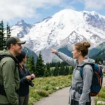
The best scenic spots are Sunrise Point, the Sunrise Visitor Center area, Sourdough Ridge, Dege Peak, and nearby meadow overlooks. These places give the strongest combination of horizon visibility, mountain framing, and easy access, with some requiring only a short walk from the road.
Sunrise Point is the most direct overlook for broad views. It is an established road pullout with panoramic sightlines across the park and beyond, and it connects to the Palisades Lakes Trail and Sourdough Ridge Trail. That makes it a strong starting point for visitors who want a sunrise view without a long hike.
The Sunrise Visitor Center area is another major base. The NPS describes Sunrise as a visitor district with exhibits, a bookstore, ranger-led activities, a day lodge, restrooms, and miles of trails. Because it sits close to trailheads and meadows, it works well for people who want a more flexible sunrise plan with both roadside and walking options.
Short trails create the next layer of scenic value. Sourdough Ridge gives a ridgeline perspective, and Dege Peak adds elevation for a wider angle over the basin. These spots are useful when the goal is to see the summit, glaciers, and surrounding peaks in one frame.
Which viewpoints suit photography?
The strongest photography viewpoints are Sunrise Point, Sourdough Ridge, Dege Peak, Mount Fremont, and the meadow edges near the visitor centre. They provide foregrounds, layers, and clean mountain profiles, which improve composition for sunrise, landscape, and wide-angle images.
Sunrise Point offers the most accessible wide landscape frame. Because it is an overlook along the road with established viewing space, photographers get stable footing and open sightlines without a strenuous climb. The surrounding rockwork and ridgeline shape also create a natural frame around Mount Rainier.
Sourdough Ridge is useful for layered compositions. The trail runs along a ridgeline from Sunrise Point toward the developed area, so it gives a series of shifting angles rather than one fixed view. That matters for sunrise photography because the light changes quickly, and moving a short distance can reveal different foregrounds, such as meadow textures, volcanic rock, or snow patches.
Mount Fremont is one of the standout hiking viewpoints in the Sunrise zone. It is listed among the area day hikes, and it appeals to photographers who want a higher perch and stronger depth in the landscape. In practical terms, that means the scene includes more of the mountain’s flanks, the basin below, and the shifting dawn colours across the sky.
Explore More Things To Do
Paradise Area Mount Rainier Visitor Guide and Hiking Tips for Washington
Which hikes reach sunrise views?
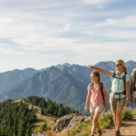
The main sunrise-oriented hikes are Sourdough Ridge, Dege Peak, Mount Fremont, Burroughs Mountain, and the Palisades Lakes approach. These trails range from short ridge walks to longer alpine hikes, and each adds altitude, distance, and different viewing angles for morning light.
Sourdough Ridge is one of the most direct trail choices from Sunrise Point. It follows the ridgeline and stays close to the Sunrise developed area, which makes it practical for a dawn outing when time is limited. The ridge setting also gives continuous views rather than a single destination point.
Dege Peak is a useful higher viewpoint on the same network. A short climb adds a more elevated perspective over the Sunrise basin, which helps when fog, low cloud, or foreground clutter reduce visibility from lower spots. This is a strong option for visitors who want a balance of effort and visual reward.
Mount Fremont and Burroughs Mountain are more ambitious sunrise hikes. The Sunrise area lists both among its day-hike options, along with Glacier Basin, Naches Peak Loop, and Silver Forest Trail. Burroughs Mountain in particular is known for close views of glaciers and rugged volcanic terrain, while Mount Fremont adds the appeal of a historic fire lookout and a broad sunrise horizon.
What is the historical context?
The Sunrise area has a long cultural and planning history, with Native American use, early road construction, and 1930s landscape design shaping the site today. Its current form reflects both preservation goals and visitor access planning within a National Park setting.
Before park development, Native American people used the meadows for hunting and gathering, and the NPS notes that these lands also held spiritual significance. That history matters because Sunrise is not just a scenic stop. It is part of a longer human landscape with continued cultural relevance.
The road and viewpoint system came later. Sunrise Point was developed as part of a road built to enhance views and connect visitors with the landscape, with construction beginning in 1927 and public opening in 1931. The Civilian Conservation Corps improved the road during the 1930s, which placed Sunrise within the broader American park-building era.
The built environment was also designed to blend with nature. The NPS states that the Sunrise buildings use log siding, stone foundations, and cedar shakes, and that the Sunrise National Historic Landmark District was intended to fit the surrounding landscape. This historical design approach explains why the area feels coherent and scenic rather than heavily urbanised.
When is the best time to go?
The best time to go is early July through late September, with the clearest sunrise conditions often arriving in mid- to late summer. Wildflower peak bloom is typically late July or early August, and visiting early or late in the day reduces crowding in this very popular area.
Seasonality is central to planning. Sunrise is open only in summer, typically from early July to late September, sometimes into mid-October depending on weather. The Sunrise Road is also seasonal, and the road status changes with snow conditions. In 2025, timed-entry reservations were required for the Sunrise Corridor during defined summer periods, showing that the area manages heavy demand during peak season.
Timing within the day matters too. The NPS says Sunrise is extremely popular and recommends arriving earlier or later in the day to avoid congestion. For sunrise viewing, that means reaching the area before first light and choosing a fixed viewpoint before parking fills.
Weather and bloom seasons add another layer. Wildflower peak bloom is usually late July or early August, while fall brings red and orange meadow colours. That gives Sunrise a clear seasonal profile: snow-adjacent scenery in early summer, peak colour in midsummer, and crisp fall tones later in the season.
How do road access and permits work?
Access to Sunrise depends on the seasonal opening of Sunrise Road, which is usually summer only and closed in winter. In 2025, timed-entry reservations applied during specific hours and dates, and the NPS road-status page should be checked before travel because conditions change quickly.
Sunrise is reached by Sunrise Road off State Route 410, and the road is typically open only from early July to late September, depending on snow. The road status page for Mount Rainier National Park currently lists Sunrise Road as closed for the season, which shows how quickly access changes in spring and early summer. That makes it one of the most important planning factors for a sunrise trip.
Vehicle limits also matter. The park notes that the road is steep, narrow, and winding, and recommends that RVs and trailers longer than 25 feet not travel beyond the White River Campground intersection. This is relevant for Washington visitors using larger vehicles, since access constraints affect arrival time and parking confidence before dawn.
Timed-entry rules add another layer in peak season. For 2025, reservations were required between 7:00 am and 5:00 pm for defined summer dates and weekends/holidays after September 1. Even though sunrise arrives before that window, visitors still need to understand the full access system because trail access, parking pressure, and road opening times all influence the trip.
What should visitors expect on site?
Visitors should expect a high-elevation alpine setting with a visitor centre, restrooms, exhibits, food service nearby, trailheads, and changing weather. Sunrise is structured for day use, but conditions remain fast-moving, cold at dawn, and strongly shaped by snow, wind, and visibility.
Sunrise is more developed than many mountain viewpoints. The area includes a visitor centre, a day lodge with a café and gift shop nearby, restrooms, maps, ranger presence, and trail access. That makes it convenient for an early visit because basic services exist once the area opens for the season.
The environment still feels alpine and exposed. Sunrise sits at 6,400 feet, so dawn temperatures are lower than in the lowlands, and weather changes quickly. The NPS also notes that the meadows have thin volcanic soil that drains quickly and supports a short growing season. Visitors should stay on trails because the plants are easily damaged in this fragile ecosystem.
The area’s geology also adds depth to the visit. Sunrise sits on early lava flows from modern Mount Rainier, with ash deposits, ancient collapse scars, and glacier features visible around the basin. That means the sunrise view is also a geological landscape, not just a visual one.
Why does Sunrise matter in Washington?
Sunrise matters because it combines iconic Washington scenery, accessible alpine viewpoints, and strong interpretive value in one place. It is one of the state’s most efficient destinations for seeing Mount Rainier, glaciers, wildflowers, and distant Cascade peaks in a single early-morning visit.
For Washington visitors, Sunrise gives one of the clearest Mount Rainier experiences available by car. At 6,400 feet, it is the highest drivable point on the mountain and offers a large-scale view of the state’s volcanic and glacial terrain. That concentration of scenery in one corridor is rare and explains why the area remains heavily visited.
It also works well for different user intents. Some travellers want a simple roadside sunrise. Others want a short hike with a big payoff. Others want photography, wildflowers, or a broader understanding of the mountain’s history. Sunrise supports all of those uses because the site includes overlooks, trails, cultural history, and visitor services.
The future relevance is strong as well. Demand remains high, access continues to be seasonally managed, and the park uses timed entry and road controls to balance visitation. That makes Sunrise a long-term evergreen topic for Washington travel content, because the core appeal stays constant even as access rules and seasonal dates change.
What is Sunrise at Mount Rainier?
Sunrise is the highest visitor-accessible area in Mount Rainier National Park, located at 6,400 feet on the mountain’s northeast side. It is famous for panoramic alpine views, glacier scenery, wildflower meadows, and some of the best sunrise photography spots in Washington.