
Spokane Falls is the largest urban waterfall system in the United States, located in downtown Spokane, Washington, with 11 prime viewing spots including the Numerica SkyRide, Huntington Park, and pedestrian suspension bridges. The falls consist of an Upper Falls (23 feet high) and Lower Falls (50–75 feet high), reaching peak flow of 20,000 cubic feet per second in April–May during mountain snowmelt.
- What is Spokane Falls and why is it significant?
- Where are the best viewing spots for Spokane Falls?
- Upper Falls Viewing Locations
- Lower Falls Viewing Locations
- Aerial Viewing
- When is the best time to visit Spokane Falls?
- How do I access Spokane Falls viewing areas?
- What historical significance does Spokane Falls hold?
- Tribal Salmon Fishing History
- Gathering at the Falls
- Washington Water Power Era
- Rediscovering Spokane Falls
- What facilities and amenities are available at viewing spots?
- How much does it cost to visit Spokane Falls viewing areas?
- What should I know before visiting Spokane Falls?
What is Spokane Falls and why is it significant?
Spokane Falls is the largest urban waterfall system in the United States, spanning 50–75 feet in height across Upper and Lower sections, with sacred significance to Spokane Tribe and 20,000 cfs peak spring flow.
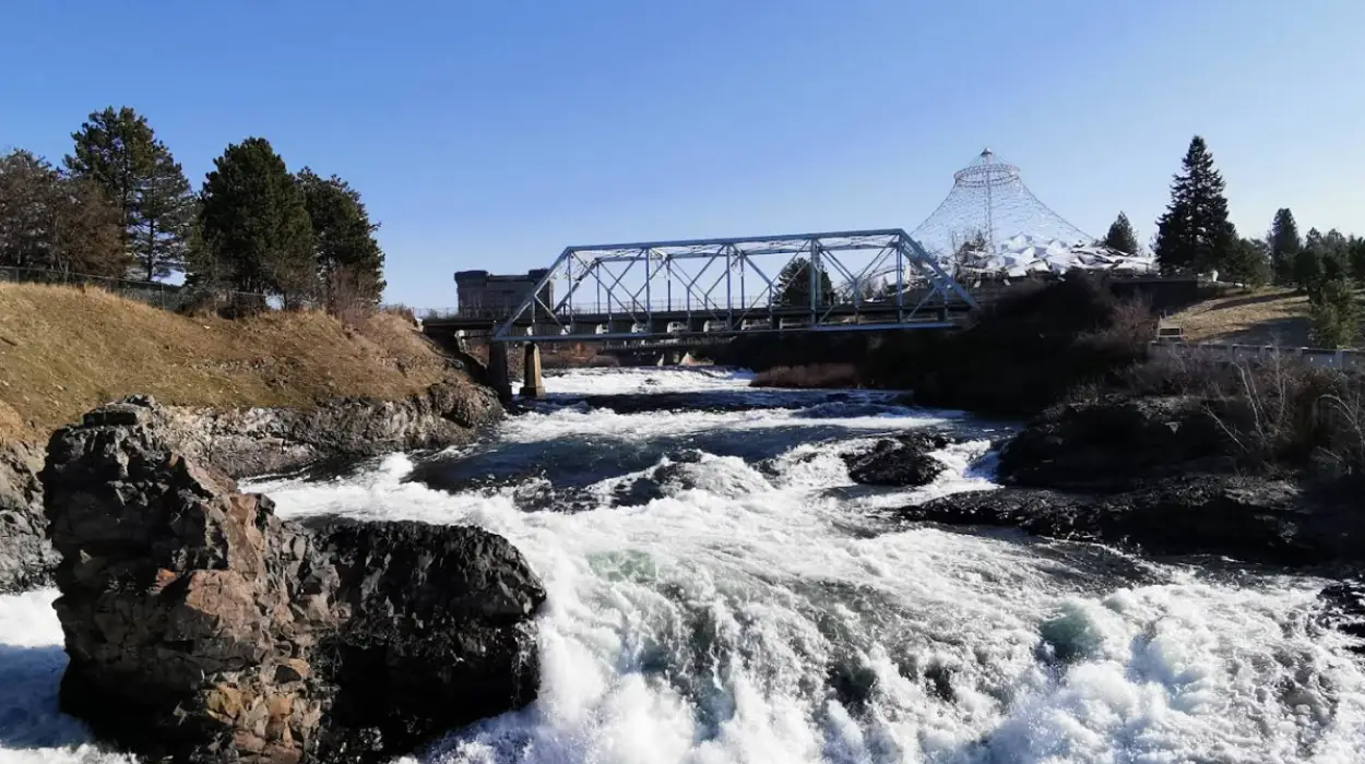
Spokane Falls comprises two main waterfalls on the Spokane River: the Upper Spokane Falls (23 feet tall) and the Lower Spokane Falls (50–75 feet tall). The Spokane River winds through thick basalt formations, carving a gorge that divides downtown Spokane. The Spokane Tribe named the falls “Stluputqu,” meaning “swift water”. The falls serve as the city’s centerpiece and attract visitors year-round for their power and natural beauty.
In 2009, Avista Utilities restored full flow to the falls, ensuring powerful water volume regardless of visit timing. Spring and early summer deliver highest flow from mountain snow runoff. Late summer and early fall reveal stunning basalt rock formations. Winter offers powerful flow combined with rock views. The falls flow averages 303 cubic feet per second annually, with spring flows exceeding 20,000 cfs and summer flows dropping below 5 cfs.

Where are the best viewing spots for Spokane Falls?
The 11 best Spokane Falls viewing spots include Pedestrian Suspension Bridges (upper falls), Huntington Park (lower falls panorama), A Place of Truths Plaza, Monroe Street Bridge, Post Street Bridge, and the Numerica SkyRide gondola for aerial views.
The best viewing spots separate into upper falls and lower falls locations. Each offers distinct perspectives and accessibility levels.
Upper Falls Viewing Locations
Pedestrian Suspension Bridges sit on Riverfront Park’s north side next to the white Washington Water Power building. Two bridges suspended by cables sway as you cross. Spring runoff often soaks the bridge with soft mist on your face. This is the closest up-close upper falls experience.
Walk from the first bridge to access lower falls viewpoints. The bridges provide direct waterfall proximity unmatched by other spots.
Lower Falls Viewing Locations
Huntington Park sits west of Riverfront Park between Mobius Science Center and City Hall. This park offers the most spectacular lower falls panorama. The Tribal Gathering Place plaza features water features and basalt stonework. Walk to viewing areas for the full lower falls panorama.
Descend stairs and read plaques outlining Spokane’s water power history. Gravel paths, sculptures, and art pieces with benches lead you right to the lower falls base. At the base, find the Salmon Chief sculpture honoring native tribes that gathered annually to fish.
A Place of Truths Plaza is the newest viewing point near City Hall along Spokane Falls Boulevard next to Monroe Street Bridge. Larger-than-life statues by Colville Tribes members remind visitors of Spokane’s indigenous heritage. Metal animal statues represent the Salish creation myth.
Walk down the plaza for river rushing views below. You’ll also see Huntington Park across the water from this location.
Post Street Bridge & Monroe Street Bridge offer prime viewpoints north of the brick Washington Water Power building. Walk Post Street Bridge north to reach the Centennial Trail. The trail descends under Monroe Street Bridge to a viewing nest at the waterfall base with Huntington Park views across water.
The Monroe Street Bridge, constructed in 1911, is one of the largest arch bridges in the U.S. When reaching bright orange Adirondack chairs on the Centennial Trail toward Kendall Yards, look back at falls framed by historic bridge arches. This permanent installation marks a great vantage point.
Aerial Viewing
Numerica SkyRide Gondola offers a 15-minute fly-over for bird’s-eye views without walking. The gondola descends 200 feet gradually for vantage points. Considered one of the best cable car rides in the world, lilac gondolas seat up to six people and are ADA compliant.
Cabin windows open for perfect photos. Most visits catch rainbows. Adult tickets cost $13.95, children 2–12 cost $9.95, and children under 2 are free. Military, seniors, and students receive 10% discounts.
When is the best time to visit Spokane Falls?
Visit Spokane Falls in April and May during peak seasonal flow when melting upstream snow creates 20,000 cfs cascades; spring offers maximum power while late summer reveals basalt formations.
Peak water flow occurs in April and May when mountain snowmelt increases volume. Spring runoff creates breathtaking cascades reaching 20,000 cubic feet per second—enough water to fill an Olympic-size swimming pool in under 5 seconds.
Late summer and early fall show reduced flow but reveal stunning basalt rock formations creating the gorge. Winter combines powerful flow with rock formation views. Year-round accessibility means the falls are visitable anytime.
Average annual flow is 303 cfs, but spring flows exceed 20,000 cfs while summer flows drop below 5 cfs historically. Recent 2026 spring data shows 20,000 cfs raging levels ahead of schedule.
How do I access Spokane Falls viewing areas?
Access Spokane Falls on foot starting at Riverfront Park, where all viewing points connect via the 40-mile Centennial Trail with 18 marked trailheads spanning Washington and Idaho states.
For first-time visitors, exploring Spokane Falls on foot is the best method. Start at Riverfront Park for easy access to observation points and attractions. Riverfront Park is the central hub connecting upper and lower falls viewpoints.
The Spokane River Centennial Trail is a 40-mile trail with 18 marked trailheads spanning Washington and Idaho states. The Riverfront Park section includes numerous Spokane Falls viewpoints. Walk the trail from Post Street Bridge north to reach the Monroe Street Bridge viewing nest under the bridge.
Continue toward Kendall Yards on the Centennial Trail and look back at falls from the orange Adirondack chairs installation.
Numerica SkyRide provides accessible aerial viewing for those preferring to skip walking. The gondola is ADA compliant and seats up to six people. Check operation hours before visiting as the SkyRide occasionally closes early due to high winds or extreme temperatures.
What historical significance does Spokane Falls hold?
Spokane Falls held sacred significance for Spokane Tribe who named it “Stluputqu” (swift water), gathering annually for Chinook salmon fishing for thousands of years before Washington Water Power built the first dam in 1890 for hydroelectricity.
Tribal Salmon Fishing History
The Spokane Tribe gathered at the falls annually to fish for upcoming winter. As giant Chinook salmon made their way up the water, men created fish traps across the water blocking fish movement. Using spears, they caught thousands of salmon.
Women processed and smoked fish to last throughout the year. Different tribes gathered annually, appointing a Salmon Chief—usually a local Spokane Tribe member—to manage fishermen and ensure even harvest distribution. The Salmon Chief served as spiritual leader holding ceremonies before fishing and blessing bounty after.
The Salmon Chief sculpture at the lower falls base honors this heritage. Installed in 2014 during Huntington Park renovation, the 12-foot steel sculpture was created by Virgil “Smoker” Merchand, a Colville Confederated Tribes member and artist.
Dams along region waterways stopped annual salmon migration. The Grand Coulee Dam on the Columbia River blocked salmon entirely, ending centuries-spanning cultural tradition.
Gathering at the Falls
The Spokane Tribe divided into Lower, Upper, and Middle groups. The falls served as gathering place for fishing, celebrations, ceremonies, games, and community time. The base where Spokane River meets Latah Creek was permanent winter camp.
The tribe still gathers annually with the Gathering at the Falls Powwow in late August, drawing tribal members regionally. Over 200 tribes have been represented through dance and song.
Washington Water Power Era
In the 1880s, settlers began using Spokane River power for electricity. A small hydroelectric dynamo installed in a flour mill provided power for about 10 street lamps. In 1889, local businessmen founded Washington Water Power, pioneering hydroelectric power.
Washington Water Power built the first dam and generator facility near Monroe Street in 1890. The company brought electricity to modern Spokane growing after a devastating fire a year earlier. New power sources lit street lamps, businesses, and streetcars.
The company, now called Avista, has provided hydroelectric power from the generator facility ever since. The dam was rebuilt in 1974 prior to the 1974 World’s Fair. The historic Washington Water Power building with recognizable green lettering remains a Spokane landmark overlooking lower falls, dam, and power station.
Visitors can experience hydroelectric power history at Mobius Science Center housed in the historic building.
Rediscovering Spokane Falls
As Spokane Falls grew into Spokane city, railroad industry moved in. Train trestles and tracks lined streets with a station along Spokane River banks. By the 1960s, train systems were obsolete, population moved away from downtown, and the waterfall was hidden beneath trestles surrounded by parking lots and rundown buildings.
In 1959, Spokane businessmen formed Spokane Unlimited to revitalize downtown. They hired city planner King Cole to save Spokane. The goal was removing train tracks and parking lots to create a central city park with the river at its heart.
Spokane bid on hosting a world’s fair and was selected as the smallest city ever to host the international event. This pumped federal and state funding into downtown redevelopment. Spokane Unlimited convinced railroads to donate property, removing train tracks and parking lots. Spokane River banks became Riverfront Park, revealing Spokane Falls hidden for decades under industrial chains.
The gondola (now SkyRide) was built as part of Expo ’74. New pedestrian suspension bridges brought visitors closer to falls for the first time in decades.
What facilities and amenities are available at viewing spots?
Viewing areas include benches at Huntington Park, interactive exhibits at Mobius Science Center, picnic areas and playgrounds in Riverfront Park, ADA-compliant SkyRide gondolas, and the Centennial Trail with accessible paths.
Huntington Park features meandering gravel paths with benches for sitting. Art pieces and sculptures are scattered thoughtfully around the park. The Tribal Gathering Place plaza includes water features and basalt stonework for reflection.
Riverfront Park offers playgrounds and picnic areas making it family-friendly. Interactive exhibits and seasonal events/festivals occur throughout the year.
Mobius Science Center in the historic Washington Water Power building provides hydroelectric power education through interactive exhibits.
The Numerica SkyRide gondola is ADA compliant with seats up to six people. Cabin windows open for photography.
The Centennial Trail features well-maintained accessible paths. Some areas may present mobility challenges, but gondola and Riverfront Park have improved accessibility.
How much does it cost to visit Spokane Falls viewing areas?
Most Spokane Falls viewing spots are free including Huntington Park, pedestrian bridges, A Place of Truths Plaza, and Centennial Trail. The Numerica SkyRide costs $13.95 for adults, $9.95 for children 2–12, and is free for children under 2.
Pedestrian Suspension Bridges, Huntington Park, A Place of Truths Plaza, Post Street Bridge, Monroe Street Bridge, and Centennial Trail access are all free public viewing areas.
Numerica SkyRide gondola costs $13.95 for adults, $9.95 for children ages 2–12, and free for children under 2. Military, seniors, and students receive 10% discounts.

What should I know before visiting Spokane Falls?
Bring comfortable walking shoes for trail access, dress in layers for changing weather, bring a camera for rainbow photography on SkyRide, arrive early to avoid crowds, and check SkyRide hours before visiting as it closes early occasionally.
Spring visits bring maximum water power with 20,000 cfs flow. Pedestrian bridges get soaked during spring runoff—bring water-resistant clothing.
SkyRide operates Monday–Sunday 10am–6pm but may close early due to high winds or extreme temperatures. Check hours before going.
Rainbows frequently appear during SkyRide rides. Open cabin windows capture perfect photos.
Arrive early to avoid crowds during peak seasons. Bring comfortable walking shoes for Centennial Trail access. Dress in layers for weather changes.
Parking is limited during peak seasons. Consider public transit or early arrival.
Year-round beauty, accessible park amenities, and rich history make Spokane Falls a top Spokane itinerary item. If you see nothing else in Spokane, see the falls.
What is Spokane Falls and why is it significant?
Spokane Falls is the largest urban waterfall system in the United States, located in downtown Spokane, Washington. The falls consist of the 23-foot Upper Falls and the 50–75-foot Lower Falls, making them the city’s most recognizable natural landmark. They also hold deep cultural importance for the Spokane Tribe, who call the falls “Stluputqu,” meaning “swift water.”


