Hurricane Ridge is the premier mountain destination within Olympic National Park, located in the U.S. state of Washington. Situated 17 miles south of Port Angeles, this subalpine region sits at an elevation of 5,242 feet ($1,598\text{ metres}$) above sea level. The ridge provides panoramic views of the Olympic Mountains, characterized by jagged, glaciated peaks, deep valleys, and subalpine meadows. Because of its accessibility by vehicle, Hurricane Ridge serves as the primary hub for alpine recreation, scientific research, and ecological education within the northern Olympic Peninsula. The area receives heavy snowfall during winter and features diverse wildflower blooms during summer, making it a critical ecological indicator for the Pacific Northwest region.
- Why Is Hurricane Ridge a Primary Destination in Olympic National Park?
- What Is the Geological History of the Olympic Mountains and Hurricane Ridge?
- How Does the Climate Shape the Environment at Hurricane Ridge?
- Which Plant Species Adapt to the Subalpine Ecosystem of Hurricane Ridge?
- What Wildlife Inhabits the Hurricane Ridge Region?
- How Do Recreational Activities Vary by Season at Hurricane Ridge?
- What Management Challenges and Future Implications Face Hurricane Ridge?
Why Is Hurricane Ridge a Primary Destination in Olympic National Park?
Hurricane Ridge is the most accessible subalpine location in Olympic National Park, offering visitors panoramic views of the Olympic Mountains, diverse hiking trails, and year-round recreational opportunities. Its unique geographical positioning provides critical ecological insights into Pacific Northwest alpine environments.
The accessibility of Hurricane Ridge establishes it as a central hub for tourism and education within Washington State. Prior to the construction of the Hurricane Ridge Road, which concluded in 1952, the high-altitude zones of the Olympic Mountains were reachable only via multi-day backpacking expeditions. The modern paved road allows vehicles to ascend from sea level at Port Angeles to over 5,000 feet in approximately 45 minutes. This infrastructure makes the subalpine ecosystem accessible to individuals of varying physical abilities, researchers carrying heavy equipment, and park rangers managing wilderness resources.
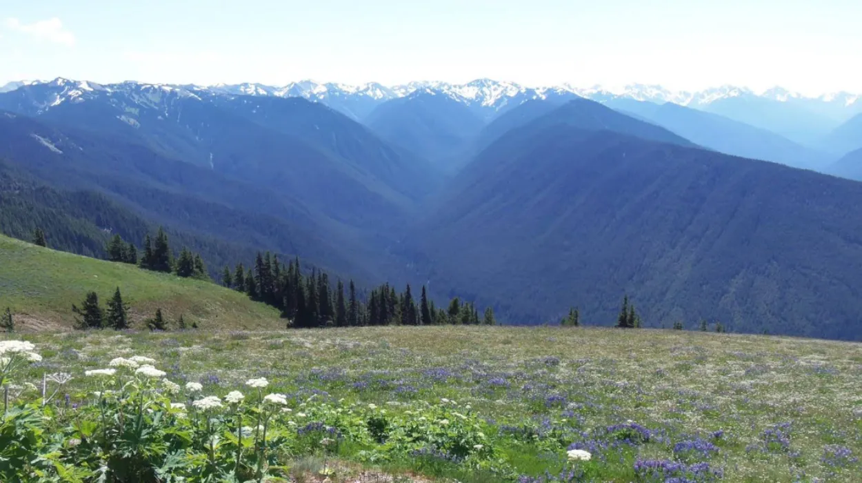
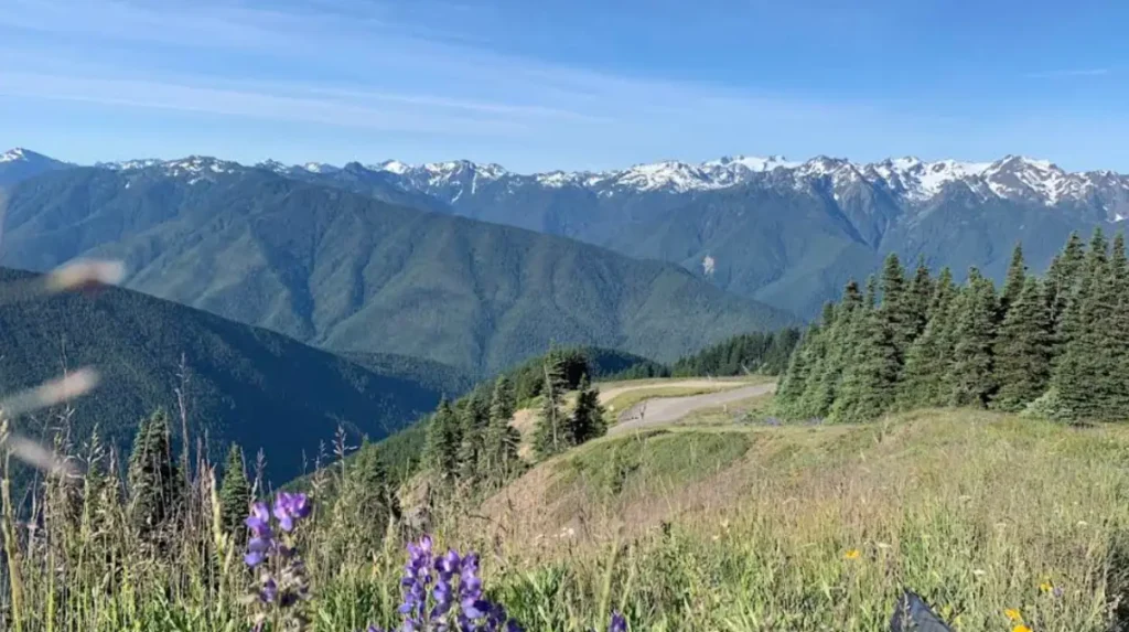
The geographic positioning of the ridge delivers unobstructed views of the interior Olympic Range. Visitors can view prominent geological formations, such as Mount Olympus, which rises to 7,965 feet ($2,428\text{ metres}$). The vantage point allows for the direct observation of several active glaciers, including the Blue Glacier, which contributes significant meltwater to the Hoh River system. The ridge acts as a natural viewing platform that illustrates the structural layout of the Olympic Peninsula, where steep elevation gradients occur over short horizontal distances.
Ecologically, Hurricane Ridge represents a distinct environmental zone known as the subalpine ecosystem. This zone functions as a transition area between the dense lowland temperate rainforests and the barren alpine tundra. The ridge experiences extreme weather variations, which shape the local flora and fauna. Scientists utilize the location to study climate patterns, snowpack longevity, and the migration habits of subalpine wildlife. The proximity of the ridge to the Pacific Ocean creates a unique microclimate where moist marine air collides with high-altitude terrain, generating high wind speeds and substantial precipitation.
Recreational diversity further cements the status of Hurricane Ridge as a primary destination. The National Park Service maintains a network of trails that cater to different skill levels, ranging from paved paths to strenuous backcountry routes. During the winter months, the area transforms into one of the few operational ski areas within a U.S. National Park, providing opportunities for snowshoeing, cross-country skiing, and downhill winter sports. This year-round utility ensures a steady influx of visitors, which supports the regional economy of Clallam County and the broader Olympic Peninsula.
What Is the Geological History of the Olympic Mountains and Hurricane Ridge?
The geological history of the Olympic Mountains involves plate tectonics, accretion, and extensive glaciation over 35 million years. Subduction forces lifted marine sedimentary rocks from the ocean floor, while subsequent ice ages carved the modern topography of Hurricane Ridge.
The formation of the Olympic Mountains began during the Eocene epoch, approximately 35 million years ago. The geological process is driven by the interaction between the Juan de Fuca plate and the North American plate along the Cascadia subduction zone. As the denser oceanic Juan de Fuca plate slid beneath the continental North American plate, immense friction scraped marine sediments and basaltic rock off the descending plate. This scraped material, known as an accretionary wedge or prism, accumulated along the continental margin. Over millions of years, tectonic compression forced these marine rocks upward, creating the Olympic mass.
The rock types found at Hurricane Ridge provide direct evidence of this marine origin. Geologists classify these rocks into two primary groups: the peripheral basaltic ring and the core rocks. The core rocks, which comprise the main peaks visible from Hurricane Ridge, consist of turbidites, sandstones, and shales that originated as underwater landslides on the ancient ocean floor. Visitors can observe exposed sedimentary layers along the ridge trails, displaying folding and faulting caused by tectonic pressure. These rocks lack the volcanic origins found in neighboring Pacific Northwest ranges, such as the Cascade Range, making the Olympics structurally distinct.
Glaciation played the secondary major role in sculpting the modern landscape of Hurricane Ridge. During the Pleistocene epoch, which spanned from 2.5 million to 11,700 years ago, multiple glacial advances covered the Olympic Peninsula. The Cordilleran Ice Sheet, flowing south from present-day British Columbia, split around the Olympic Mountains, moving through the Strait of Juan de Fuca to the north and the Puget Sound trough to the east. Concurrently, alpine glaciers formed on the highest peaks of the Olympics and flowed outward through river valleys.
These dual glacial forces carved the sharp features visible from Hurricane Ridge today. The ice sheets eroded the northern slopes of the ridge, while alpine glaciers excavated deep, U-shaped valleys, such as the Elwha River Valley and the Dungeness River Valley. When the glaciers retreated at the end of the Last Glacial Period, approximately 14,000 years ago, they left behind moraines, erratics, and exposed ridgelines. The flat, meadows of Hurricane Ridge are the direct result of glacial scouring followed by centuries of soil accumulation from decomposing subalpine vegetation.
How Does the Climate Shape the Environment at Hurricane Ridge?
The climate at Hurricane Ridge features high wind speeds, heavy winter snowfall, and brief, dry summers. This severe weather pattern dictates the structural adaptations of local vegetation, determines wildlife behavior, and influences seasonal park accessibility.
The geographic location of Hurricane Ridge subjects it to a maritime alpine climate. The ridge stands as the first major topographical barrier for storms moving eastward across the Pacific Ocean. When moisture-laden air masses hit the Olympic Mountains, they are forced upward in a process known as orographic lift. As the air rises, it cools and condenses, releasing large volumes of precipitation. At an elevation of 5,242 feet, this precipitation falls predominantly as snow from November through April, with average annual snowfall totals reaching 400 inches ($1,016\text{ centimetres}$).
This massive snowpack remains on the ground well into the spring and summer months, acting as a critical water reservoir for the surrounding lowlands. The weight and duration of the snowpack compress the soil and limit the growing season for plants to approximately 90 days. Vegetation must complete its reproductive cycle quickly once the snow melts, usually between July and September. The slow melting process ensures a continuous supply of moisture to the subalpine meadows during the dry summer months when regional rainfall decreases significantly.
Wind is another defining climatic factor at Hurricane Ridge, giving the location its name. Winter storms regularly generate wind speeds exceeding 60 miles per hour ($96.5\text{ kilometres per hour}$), with peak gusts occasionally surpassing 100 miles per hour. These winds cause significant wind chill, transport snow across the terrain to create large drifts, and inflict mechanical damage on exposed trees. The combination of high winds and freezing temperatures causes severe desiccation, stripping moisture from exposed plant tissues and killing needles on the windward sides of trees.
The interactions between temperature, wind, and snowfall create distinct microclimates across Hurricane Ridge. South-facing slopes receive more direct solar radiation, causing the snow to melt earlier and supporting different plant communities than north-facing slopes, which remain shaded and ice-covered longer. These climatic pressures force flora to adapt structurally. Trees near the timberline display a growth form known as krummholz, where trunks become stunted, twisted, and multi-branched due to persistent wind and ice blasting.
Which Plant Species Adapt to the Subalpine Ecosystem of Hurricane Ridge?
The plant species at Hurricane Ridge include subalpine firs, mountain hemlocks, and diverse perennial wildflowers. These plants possess specialized physiological and structural adaptations to survive brief growing seasons, heavy snow loads, and intense ultraviolet radiation.
The tree line at Hurricane Ridge is dominated by two primary coniferous species: the subalpine fir (Abies lasiocarpa) and the mountain hemlock (Tsuga mertensiana). Subalpine firs feature a narrow, spire-like crown that prevents excessive snow accumulation on their branches, reducing the risk of structural breakage during heavy winter storms. Their flexible branches bend downward under weight, allowing snow to slide off naturally. Mountain hemlocks thrive in areas with deeper, longer-lasting snowpacks, often growing in clusters known as tree islands. These clusters create a shared microclimate that protects younger saplings from the wind.
Below the tree line, the subalpine meadows contain an array of perennial wildflowers that bloom in a predictable sequence following the spring snowmelt. One of the earliest species to emerge is the avalanche lily (Erythronium montanum), which can grow directly through thin layers of receding ice. The bulb of the avalanche lily stores energy from the previous year, allowing for rapid growth and flowering before competing species emerge. Following the lilies, the meadows fill with subalpine lupine (Lupinus arcticus), Indian paintbrush (Castilleja), and American bistort (Bistorta bistortoides).
The harsh environment requires specific physiological adaptations among these herbaceous plants. Many species, such as the woolly sunflower or alpine smelowskia, feature fine hairs covering their leaves and stems. These hairs insulate the plant against sudden temperature drops, reduce water loss caused by drying winds, and deflect intense ultraviolet radiation at high elevations. Other plants grow close to the ground in cushion-like formations, which traps warmth radiated from the soil and minimizes exposure to high-velocity winds.
Hurricane Ridge also hosts several endemic plant species, which are organisms that grow natively only within a specific geographic boundary. The Olympic Mountain groundsel (Senecio neowebsteri) and the Flett’s violet (Viola flettii) evolved in isolation on the Olympic Peninsula after glaciers isolated the mountain peaks from the mainland. These endemic species typically occupy rocky crevices and talus slopes where competition from more aggressive meadow plants is low. Their preservation is a primary objective for National Park Service conservationists.
What Wildlife Inhabits the Hurricane Ridge Region?
The wildlife of Hurricane Ridge consists of specialized mammals, birds, and invertebrates adapted to high-altitude living. Key resident species include the endemic Olympic marmot, black-tailed deer, Olympic black bears, and various avian species like the Canada jay.
The Olympic marmot (Marmota olympus) is the most distinct mammal residing at Hurricane Ridge, as it is entirely endemic to the Olympic Mountains. These rodents inhabit subalpine meadows and rocky scree fields, where they dig extensive burrow systems for protection against predators and extreme weather. Olympic marmots exhibit a highly social structure, living in colonies composed of a dominant male, several females, and their offspring. They enter a state of deep hibernation for up to eight months of the year, typically from October to May, during which their metabolic rate decreases significantly to conserve energy reserves accumulated during the summer.
Colonies face predation from several native species, including the cougar (Puma concolor) and the golden eagle (Aquila chrysaetos). To mitigate this threat, marmots utilize a system of vocalizations, emitting high-pitched whistles to alert the colony of approaching danger. The introduction of the non-native mountain goat (Oreamnos americanus) in the 1920s altered the subalpine habitat by causing soil erosion through wallowing and competing for forage. The National Park Service initiated a relocation and management plan in 2018 to remove mountain goats from the park, thereby protecting the native vegetation and marmot habitats.
Other large mammals frequently observed at Hurricane Ridge include the Columbian black-tailed deer (Odocoileus hemionus columbianus) and the Olympic black bear (Ursus americanus altifrontalis). Black-tailed deer migrate to the ridge during the summer months to feed on the nutrient-rich subalpine grasses and wildflowers. They display a high degree of habituation to human presence near paved trails, though park regulations strictly prohibit feeding to prevent behavioral dependency. Black bears utilize the ridge to forage for berries, insects, and roots, entering torpor during the winter season when food becomes scarce.
The avian population at Hurricane Ridge includes both year-round residents and migratory species. The Canada jay (Perisoreus canadensis), also known as the gray jay, is highly visible along the ridgelines. These birds possess specialized salivary glands that allow them to sticky-glue food items, such as seeds and insects, to tree bark above the winter snowline, ensuring a constant food supply. Other notable avian species include the sooty grouse (Dendragapus fuliginosus), which utilizes subalpine firs for cover, and the common raven (Corvus corax), which exploits thermal updrafts generated by the steep mountain topography.
How Do Recreational Activities Vary by Season at Hurricane Ridge?
Recreational activities at Hurricane Ridge switch between summer hiking, sightseeing, and educational programs, and winter downhill skiing, snowshoeing, and snowboarding. The National Park Service regulates these activities to ensure visitor safety and preserve vulnerable subalpine ecosystems.
Summer recreation at Hurricane Ridge extends from late June through September, drawing the highest volume of annual visitors. The primary activities involve hiking along the managed trail network, which includes three categories of paths: paved interpretative walkways, moderate ridgeline trails, and strenuous wilderness descents. The Big Meadow Trail is a 0.5-mile paved loop that accommodates visitors seeking accessible viewing points of the Olympic range. The Hurricane Hill Trail is a 3.2-mile round-trip paved path that ascends 650 feet ($198\text{ metres}$) to a summit, providing views of the Strait of Juan de Fuca and Vancouver Island in British Columbia.
For advanced hikers, trails such as the Klahhane Ridge Trail or the Obstruction Point Road routes offer access to the interior wilderness. These unpaved trails traverse steep terrain, loose shale, and exposed ridges, requiring appropriate navigation skills and physical conditioning. The National Park Service operates guided ranger programs during the summer, including educational walks focused on geology, botany, and wildlife ecology. These programs aim to increase public awareness regarding the fragility of the subalpine environment.
Winter recreation begins in late November or December, depending on snow accumulation, and continues into March. Hurricane Ridge is one of only three locations within a U.S. National Park that operates a mechanized ski lift system. The Hurricane Ridge Winter Sports Club manages the ski area, which includes two rope tows and one Poma lift. This infrastructure provides access to downhill skiing, snowboarding, and tubing terrain. The winter sports operations cater to a local customer base from Washington State, emphasizing affordable, community-oriented winter recreation.
Snowshoeing and cross-country skiing represent the primary non-mechanized winter activities. The National Park Service marks winter trails along the snow-covered Obstruction Point Road, allowing winter recreationists to travel into the backcountry. Rangers lead guided snowshoe walks on weekends, providing participants with equipment and safety education regarding winter survival and avalanche awareness. Due to the severe winter weather conditions, the Hurricane Ridge Road is subject to strict management, requiring all vehicles to carry snow chains and operating only on specific days of the week, weather permitting.
What Management Challenges and Future Implications Face Hurricane Ridge?
Management challenges at Hurricane Ridge include infrastructure restoration following catastrophic fires, mitigating human impact on fragile meadows, and adapting to climate change. Long-term preservation requires balancing public access with ecological conservation and resource monitoring.
The most immediate management challenge at Hurricane Ridge involves infrastructure recovery. In May 2023, a catastrophic fire destroyed the historic Hurricane Ridge Visitor Center, a structure built in the 1950s that housed interpretive exhibits, administrative offices, and public amenities. The loss of this facility altered park operations, forcing the National Park Service to deploy temporary structures, portable restrooms, and mobile ranger stations to sustain visitor access. The planning, funding, and construction of a sustainable, modern visitor center represent a long-term administrative effort that must meet current environmental building regulations within a national park.
Human impact mitigation remains a continuous operational focus. The high volume of visitors concentrated on the ridge creates pressure on the local environment. Off-trail hiking causes soil compaction, destroys delicate alpine vegetation, and accelerates erosion on steep slopes. Once subalpine soil is eroded, it can take decades to recover due to the short growing season. To counter this, the park employs trail designs, physical barriers, and educational signage to keep visitors on designated paths. Ranger patrols enforce regulations regarding litter disposal, pet restrictions, and wildlife harassment.
Climate change presents a systemic threat to the long-term ecological stability of Hurricane Ridge. Long-term scientific monitoring indicates a general trend of decreasing winter snowpack and earlier spring snowmelts across the Olympic Peninsula. A reduced snowpack alters the hydrological cycle of the subalpine meadows, leading to drier soil conditions during the peak summer months. This moisture stress increases the vulnerability of subalpine forests to insect infestations, such as the mountain pine beetle, and heightens the risk of high-altitude wildfires.
Furthermore, changing climate conditions alter the distribution of plant and animal species. Lower-elevation tree species, such as the Douglas fir (Pseudotsuga menziesii), are slowly encroaching into the subalpine meadows, a process known as conifer encroachment. This migration reduces the total surface area of open meadows, directly threatening the specialized wildflowers and the endemic wildlife, such as the Olympic marmot, that depend on open grassland habitats. The National Park Service collaborates with academic institutions to monitor these environmental changes, utilizing data to formulate adaptive management strategies aimed at preserving the unique features of Hurricane Ridge.
Where is Hurricane Ridge located?
Hurricane Ridge is located within Olympic National Park in Washington State, approximately 17 miles south of Port Angeles.