
Eastern Washington holds a different travel identity from the state’s western half. It combines dry-steppe landscapes, river canyons, wildlife refuges, rolling Palouse hills, state parks, and small towns with distinct local history.traveltips.
- What makes Eastern Washington a hidden gems destination?
- Where should first-time visitors start?
- Why is the Palouse so distinctive?
- Which natural landmarks are essential?
- Which small towns are worth visiting?
- What makes Gardner Cave special?
- How should travelers plan the route?
- What kinds of experiences define the region?
- Why does Eastern Washington rank well for evergreen travel content?
- Which hidden gems deserve attention?
- What should visitors remember before going?
What makes Eastern Washington a hidden gems destination?
Eastern Washington is a high-value travel region built around wide-open landscapes, fewer crowds, and distinct natural landmarks. Its travel appeal comes from scenic byways, state parks, wildlife refuges, and small towns that sit far from the state’s busiest tourism corridors.
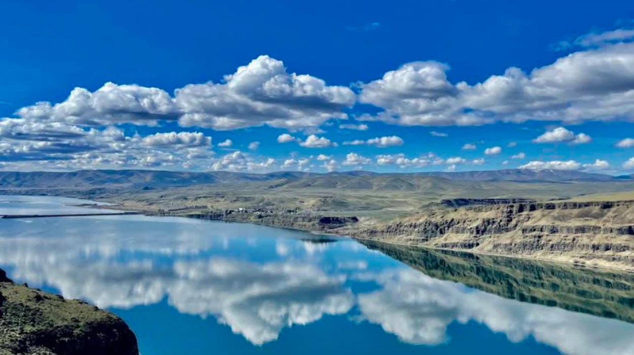
The region stretches from the Canadian border to Pullman and the Palouse, with Spokane as its largest city and major gateway. The eastern side of the state sits in a rain shadow created by the Cascade Mountains, which produces drier conditions and a very different landscape from western Washington. That geography shapes the region’s travel character and creates strong contrast between farmland, basalt cliffs, river valleys, and forested uplands.traveltips.
Eastern Washington also sees less tourism than the Puget Sound region, which leaves more room for travelers seeking quieter stops. State tourism data cited in regional coverage shows the Eastern region drew about 15 million trips in 2024, compared with 34.6 million trips in the Metro Puget Sound region. That gap explains why many sites here still feel underexplored even when they are nationally significant.

Where should first-time visitors start?
First-time visitors should begin with Spokane, the Palouse, and the Columbia Basin because those three areas show the full range of Eastern Washington travel. They combine urban access, iconic scenery, and easy day-trip structure.
Spokane works as the most practical base because it has the region’s largest city infrastructure and direct access to Riverfront Park, Spokane Falls, and Mount Spokane State Park. The Palouse delivers the classic rolling-hill landscape that defines eastern Washington photography and rural scenery. The Columbia Basin adds basalt cliffs, wildlife habitat, and signature landmarks such as Palouse Falls and Columbia National Wildlife Refuge.
Travelers who want a short, balanced itinerary can connect these areas in one loop. Spokane gives an urban start, Pullman and the Palouse provide regional culture and farming landscapes, and the Columbia Basin adds dramatic natural features. That structure covers the region’s major geographic and cultural identities without long backtracking.
Why is the Palouse so distinctive?
The Palouse is distinct because its rolling hills, fertile soil, and seasonal crop patterns create one of Washington’s most recognizable inland landscapes. The region also links scenic driving with agriculture, college-town culture, and outdoor access.
The Palouse Scenic Byway is one of the region’s strongest travel anchors. Washington tourism describes it as a photographer’s landscape of green spring fields and gold, brown, and mauve summer tones created by mineral-rich soil and wheat farming. Kamiak Butte, a quartzite rise near Palouse and Pullman, adds elevation and panoramic views above the surrounding fields.
Pullman provides the human center of the Palouse. It is home to Washington State University and the annual National Lentil Festival, which reflects the area’s agricultural identity. This makes the region more than a scenic drive; it also functions as a working agricultural landscape with local food culture and university energy.
Which natural landmarks are essential?
The essential natural landmarks are Palouse Falls, Columbia National Wildlife Refuge, and Mount Spokane State Park. Together they represent the region’s waterfall, wetland, and mountain ecosystems.
Palouse Falls is Washington’s official state waterfall, designated by state law in 2014. The falls drop 198 feet into the Snake River canyon and remain one of the state’s most recognizable geological landmarks. The site works well for day trips because the overlook experience is direct and highly photogenic.
Columbia National Wildlife Refuge showcases the region’s ice-age flood geology and desert-wetland mix. The U.S. Fish and Wildlife Service says the refuge is known for birdwatching, fishing, and trail access, and it highlights Rimrock Trail and Pipistrelle Cliffs as ways to see the flood-carved terrain. The refuge also prohibits camping and overnight parking, so it functions best as a day-use natural area.
Mount Spokane State Park anchors the northwestern side of Eastern Washington’s outdoor scene. It is the state’s largest state park, and it supports hiking in warmer months and skiing in winter. That seasonality gives travelers a year-round mountain option without leaving the region.
Which small towns are worth visiting?
The strongest small-town stops are Cheney, Chewelah, Newport, Republic, and Pullman because each offers a different travel role. They cover college culture, arts, forest access, fossil history, and river recreation.
Cheney works as a compact college town with outdoor access and easy regional connections. Chewelah adds an arts-oriented stop with golf and nearby ski terrain. Newport, near the Idaho border, gives river access, boating, fishing, and forested escapes along the Pend Oreille corridor.
Republic stands out for fossil hunting and paleontology interest. Pullman adds a university-town layer with food, events, and access to the Palouse Scenic Byway. These towns matter because they turn a scenic drive into a multi-stop regional itinerary rather than a one-photo visit.
What makes Gardner Cave special?
Gardner Cave is special because it is Washington’s longest limestone cave and one of the region’s most unusual underground attractions. It gives Eastern Washington a major geology stop beyond cliffs, canyons, and waterfalls.
The cave sits inside Crawford State Park in extreme northeastern Washington. It measures 1,055 feet in length, though only the first 494 feet are open to public access. That limited access makes the site feel more protected and more structured than a typical roadside stop.
The cave also fits the region’s broader geology story. Eastern Washington’s landscapes were shaped by ice-age floods, basalt formations, and sedimentary and volcanic processes, and Gardner Cave adds subterranean limestone to that mix. For travelers interested in landforms, it is one of the clearest “hidden gem” examples in the state.
How should travelers plan the route?
The best route is a regional loop built around Spokane, the Palouse, the Columbia Basin, and the Northeast corner. That pattern keeps driving efficient while covering the strongest landmarks, town stops, and natural settings.
A practical plan begins in Spokane, then moves south through the Palouse toward Pullman and Palouse Falls. From there, travelers can extend west and north toward Columbia National Wildlife Refuge, then continue toward northeastern destinations such as Crawford State Park and Gardner Cave. This creates a route with clear landscape transitions rather than repeated scenery.
Timing matters because Eastern Washington has hot summers from June through September and cold winters from November through February with snowfall. Summer works best for long scenic drives, waterfall viewing, and high-access hiking. Winter suits skiing, snow scenery, and city-based travel with shorter daylight planning.
What kinds of experiences define the region?
The region is defined by six major travel experiences: waterfall viewing, scenic byway driving, wildlife observation, hiking, small-town exploration, and agricultural tourism. Each experience reflects a different part of Eastern Washington’s geography and economy.
Waterfall viewing centers on Palouse Falls and Spokane Falls. Scenic byway driving is strongest on the Palouse Scenic Byway and the North Pend Oreille Scenic Byway. Wildlife observation is especially strong at Columbia National Wildlife Refuge, where birdwatching is a primary activity.
Hiking is available in places like Mount Spokane State Park and around the Palouse hills. Small-town exploration adds local identity through Pullman, Republic, Newport, Chewelah, and Cheney. Agricultural tourism appears through the Palouse’s wheat fields and Pullman’s lentil heritage. These layers make the region useful for both short trips and longer road trips.
Why does Eastern Washington rank well for evergreen travel content?
Eastern Washington ranks well for evergreen travel content because its core attractions stay relevant across seasons and years. Landforms, state parks, scenic byways, and cultural towns create stable search demand and long-lasting audience interest.
The region’s strongest search topics are not tied to a single event date. They include Palouse Falls, Spokane Falls, Gardner Cave, Mount Spokane State Park, the Palouse Scenic Byway, and Columbia National Wildlife Refuge. Those are durable destinations with institutional backing and recurring visitor interest.
The geography also supports semantic coverage. A strong article can connect waterfalls, geology, towns, wildlife refuges, and road-trip planning in one topical cluster without forcing unrelated sections. That structure helps search engines and AI systems extract destination entities, travel intent, and route-based context from a single guide.
Explore More Things to do
Things to Do in Spokane Washington for Tourists: Top Attractions & Activities
Spokane Falls Best Viewing Spots Complete Visitor Guide Washington Waterfall
Which hidden gems deserve attention?
The most overlooked gems are Columbia National Wildlife Refuge, Gardner Cave, Kamiak Butte, Republic, and the North Pend Oreille corridor. These places sit outside the state’s most crowded tourism narratives while still offering strong visitor value.
Columbia National Wildlife Refuge delivers rare landscape variety in one protected area, with cliffs, lakes, marshes, and bird habitat. Gardner Cave adds a rare cave experience in a state better known for mountains and forests. Kamiak Butte gives elevated views over the Palouse without the scale or traffic of major mountain destinations.
Republic stands out for fossil-related interest, while the North Pend Oreille Scenic Byway links small communities, forests, and cave access into one northern travel corridor. These places are strong “hidden gem” candidates because they combine authenticity, low congestion, and identifiable regional character.

What should visitors remember before going?
Visitors should plan for distance, weather, and access rules because Eastern Washington rewards preparation. The region is broad, seasonal, and shaped by protected lands with specific use restrictions.
Travelers should check park and refuge rules before arrival. Columbia National Wildlife Refuge, for example, is open sunrise to sunset, bans camping, limits drone use, and requires pets on leash. This matters because some Eastern Washington sites are conservation areas rather than general recreation zones.
Visitors should also expect big temperature shifts between summer and winter. Carry water in warm months, allow extra drive time between rural stops, and confirm reservations where needed, especially for cave tours and state park access. That preparation turns a long-distance trip into a smoother and more complete Eastern Washington experience.
What makes Eastern Washington a hidden gems destination?
Eastern Washington is known for wide-open landscapes, scenic byways, river canyons, wildlife refuges, state parks, and small towns that receive fewer visitors than western Washington. The region offers quieter travel experiences, diverse geography, and unique natural attractions ranging from basalt cliffs to rolling farmland.


