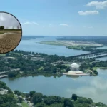
The Spokane River is a principal 111-mile (179 km) tributary of the Columbia River, draining a high-desert and mountainous urban basin across northern Idaho and eastern Washington. Originating from the outlet of Lake Coeur d’Alene, the river flows westward through the Spokane Valley, bisects the city center of Spokane, and terminates at Franklin D. Roosevelt Lake. This waterway provides critical ecological, cultural, and municipal functions while serving as a primary regional destination for non-motorized watercraft navigation and shoreline pedestrian recreation. Managing agency frameworks and local conservation entities oversee infrastructure to ensure sustainable public access across distinct hydrological zones.
- What Is the Hydrological and Ecological Background of the Spokane River?
- How Did Human Settlements Adapt Along the Spokane River Historically?
- What Are the Prime Kayaking Segments and Access Points on the Spokane River?
- What Navigation Rules and Hydrological Safety Standards Apply to Spokane River Paddlers?
- What Are the Premier Scenic Walking Trails Along the Spokane River Corridor?
- What Visual Landmarks and Points of Interest Line the River Trails?
- How Do Resource Conservation Frameworks Manage the Spokane River Corridor?
- What Future Trends and Climate Impacts Face the Spokane River Basin?
What Is the Hydrological and Ecological Background of the Spokane River?
The Spokane River is an unconfined aquifer-fed waterway shaped by glacial basalt geometry, draining 6,290 square miles across two states to support native redband trout populations while powering municipal hydro-infrastructure across seven distinct production dams.
The structural configuration of the Spokane River is inextricably linked to the Spokane Valley-Rathdrum Prairie Aquifer. This underground water source exchanges millions of gallons of water daily with the river channel. East of the Washington-Idaho state line, the river loses volume into the gravel substrate of the aquifer. West of Sullivan Road in Spokane Valley, the process reverses as cold groundwater enters the riverbed, lowering water temperatures to less than 55 degrees Fahrenheit (13 degrees Celsius) during summer months. This temperature drop provides critical thermal refuge for the Columbia River redband trout (Oncorhynchus mykiss gairdneri), a native species of concern protected under Washington State Department of Fish and Wildlife regulations.
Geologically, the river cuts through Miocene-epoch Columbia River Basalt Group formations, creating steep vertical canyons, drop-pool rapid structures, and alluvial gravel bars. The total elevation drop across its course is approximately 1,075 feet (328 meters). This steep gradient prompted the construction of seven hydroelectric projects, known collectively as the Spokane River Hydroelectric Project, operated under Federal Energy Regulatory Commission licenses. These installations include the Post Falls Dam, Upriver Dam, and Monroe Street Dam. These structures alter natural seasonal flow regimes, which historically varied from spring snowmelt peaks exceeding 30,000 cubic feet per second to late-summer minimums below 1,000 cubic feet per second.
How Did Human Settlements Adapt Along the Spokane River Historically?
Indigenous Spokane tribal populations established permanent winter villages at primary river falls for salmon harvesting, preceding nineteenth-century Euro-American industrial developments that transformed the river into a concentrated manufacturing hub and rail transport center.
Human interaction with the Spokane River began thousands of years prior to European contact. The Spokane Tribe of Indians, part of the Interior Salish linguistic group, utilized the river as their primary economic and spiritual resource. The Spokane Falls, a series of cascading waterfalls located in what is now downtown Spokane, served as a regional gathering point for multiple regional tribes during the annual summer salmon runs. Indigenous fish traps and spears targeted Chinook salmon (Oncorhynchus tshawytscha), which migrated from the Pacific Ocean up the Columbia and Spokane rivers to spawn in clean gravel reaches.
The construction of the first Euro-American sawmills and flour mills at the falls in 1871 initiated a period of intense industrial modification. The arrival of the Northern Pacific Railroad in 1881 accelerated urban growth, turning the riverfront into a dense network of rail yards, warehouses, and industrial processing plants. These activities resulted in direct environmental degradation, as industrial waste, untreated municipal sewage, and heavy metals from the upstream Coeur d’Alene Mining District accumulated in the river sediment.
The environmental trajectory of the urban river section shifted significantly with the staging of Expo ’74, the 1974 World’s Fair. This event served as the catalyst for the removal of industrial rail yards from the river banks, the creation of the 100-acre Riverfront Park, and the initial enforcement of clean water initiatives under the Federal Clean Water Act of 1972.
What Are the Prime Kayaking Segments and Access Points on the Spokane River?
Kayakers navigate three distinct sectors of the Spokane River including the flatwater upper reach, the technical urban whitewater canyon, and the slow-moving reservoir waters of Lake Spokane, using designated municipal boat launches.
The upper reach of the Spokane River extends from the Washington-Idaho state line downstream to the Upriver Dam. This 18-mile stretch features slow currents and minimal gradient, making it suitable for recreational touring kayaks and stand-up paddleboards. A primary access infrastructure asset in this section is the Harvard Road North Access Site, managed by the Washington Department of Fish and Wildlife. Downstream from this point, paddlers frequently utilize Barker Road Access and Mirabeau Point Park for entry and exit. Another highly utilized flatwater zone is Boulder Beach, located on Upriver Drive in Spokane Valley, which features sandy shorelines and direct vehicle parking.
The middle reach begins below the downtown falls and transitions into a dramatic whitewater canyon. The primary launch point for this technical sector is Redband Park, formerly known as Glover Field, located in the Peaceful Valley neighborhood. From Redband Park, the river flows through the Great Gorge loop past the confluence of Latah Creek, also known as Hangman Creek.
Advanced paddlers enter the river further downstream at the TJ Meenach Boat Launch to access Class II and Class III rapids within Riverside State Park. These whitewater features include the Bowl and Pitcher rapids and the Devil’s Toenail drop-pool structure. The standard egress point for this whitewater run is Plese Flats Recreation Area, which provides an off-loading zone before the river reaches Nine Mile Dam.
The lower reach of the river consists of Lake Spokane, a 24-mile reservoir created by the Long Lake Dam. This section features negligible current and deep water, catering to open-water touring and sea kayaking. The primary access point for the lower reach is the Nine Mile Recreation Area Boat Launch, which requires vehicles to display a Washington State Discover Pass.
What Navigation Rules and Hydrological Safety Standards Apply to Spokane River Paddlers?
Paddlers must comply with mandatory personal flotation device laws, monitor real-time United States Geological Survey flow gauges, and avoid specific seasonal hazards such as strainers and hydraulic low-head dams.
Washington State Law and Spokane County Code enforce strict safety protocols for all non-motorized vessels, including kayaks, canoes, and stand-up paddleboards. Every vessel must carry one U.S. Coast Guard-approved Personal Flotation Device (PFD) per individual, and children aged 12 years or younger must wear their life jackets at all times while on the water. Additionally, all watercraft must be equipped with a sound-signaling device, such as a marine whistle, to communicate intentions or distress in low-visibility conditions or technical rapids.
Hydrological monitoring is an essential prerequisite for any river excursion. The United States Geological Survey maintains the Spokane River near Spokane Gauge (Station 12422500), which transmits real-time volumetric discharge data. Recreational floating and beginner kayaking are generally restricted to flow rates below 2,500 cubic feet per second.
Flow rates between 2,500 and 6,000 cubic feet per second increase velocity and require intermediate swiftwater navigation skills. Discharge rates exceeding 10,000 cubic feet per second create high-velocity currents, large standing waves, and extreme thermal hazards due to spring snowmelt runoff.
Paddlers must maintain awareness of distinct physical river hazards. Strainers, which are fallen trees or submerged root balls anchored along the riverbanks, present severe entrapment risks when high currents force watercraft into the branches.
Furthermore, low-head dams, such as the structures found at Upriver Dam and Nine Mile Dam, create dangerous recirculating hydraulic traps. Boaters must strictly observe the universal warning buoy lines and exit the river at designated portage points well upstream of these industrial facilities.
What Are the Premier Scenic Walking Trails Along the Spokane River Corridor?
The primary pedestrian infrastructure along the river corridor is the 40-mile paved Spokane River Centennial State Park Trail, supplemented by unpaved dirt networks inside the Riverside State Park trail system.
The Spokane River Centennial State Park Trail is the backbone of pedestrian and non-motorized transport in Eastern Washington. This 40-mile (64 km) continuously paved, Class I multi-use path follows the contours of the river from the Nine Mile Recreation Area eastward through downtown Spokane to the Idaho state line, where it links directly with the North Idaho Centennial Trail. The trail features a standard width of 10 feet (3 meters) and is ADA accessible, accommodating walkers, runners, inline skaters, and cyclists. It registers more than 2.5 million user visits annually, making it the most heavily utilized linear state park asset in the region.
For pedestrians seeking unpaved, primitive trail experiences, the Riverside State Park network provides more than 55 miles of dirt trails. The prominent route in this sector is the Bowl and Pitcher Loop Trail (Trail 25), which walkers access by crossing the historic swinging suspension bridge built by the Civilian Conservation Corps in 1933. This trail winds through old-growth Ponderosa pine (Pinus ponderosa) stands and offers elevated views of rugged Miocene basalt columns.
Closer to the urban core, the South Gorge Trail in the Kendall Yards neighborhood provides a 1.5-mile paved loop that overlooks the Spokane River Gorge, offering views of the native vegetation restoration zones managed by local civic groups.
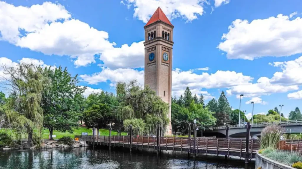
What Visual Landmarks and Points of Interest Line the River Trails?
Pedestrians crossing the river corridor encounter historical industrial installations, geological basalt formations, municipal urban parks, and architectural bridges that span the moving water.
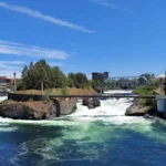
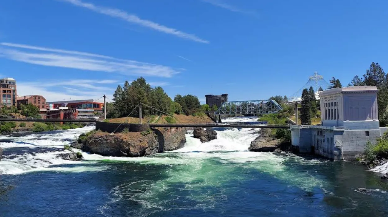
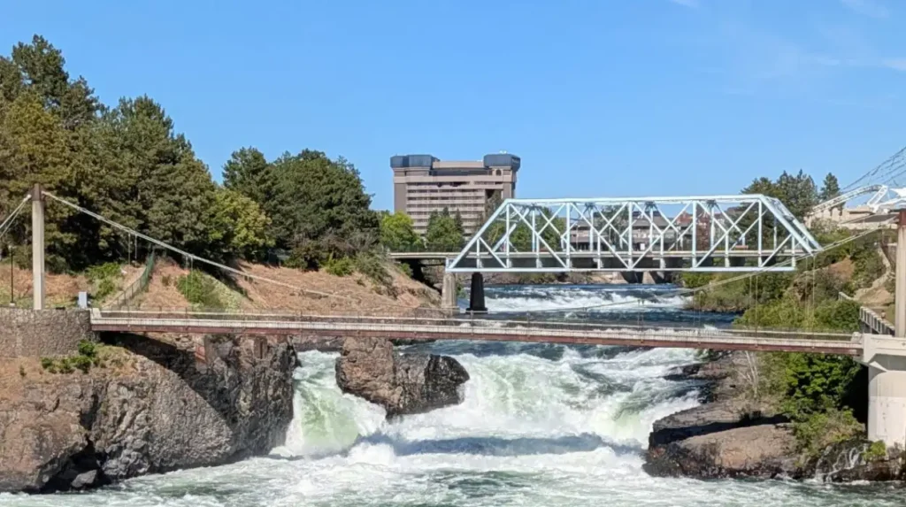
The urban center of the trail system features Riverfront Park, which contains the refurbished Looff Carrousel built in 1909, the iconic 155-foot steel Expo ’74 Pavilion structure, and multiple dedicated viewing platforms overlooking the Upper and Lower Spokane Falls. The falls represent one of the largest urban waterfall networks in the United States, generating significant spray and acoustic volume during the spring peak run-off months. Walking west from the park, pedestrians pass the Monroe Street Bridge, a historic concrete arch bridge completed in 1911 that stands 136 feet above the river gorge and features decorative bison skulls cast into its architectural pavilions.
Further downriver within the basalt canyon of Riverside State Park, the primary landmark is the Bowl and Pitcher geological formation. These large, detached basalt blocks came from ancient lava flows and rolled into the river channel, creating turbulent Class III whitewater features.
Near the western terminus of the Centennial Trail stands the historic Nine Mile Dam and Powerhouse, completed in 1908. This facility is listed on the National Register of Historic Places and represents an early example of high-head hydroelectric development in the Pacific Northwest.
Along the eastern valley reaches, trail users pass the Mirabeau Point Park waterfall and the Plante’s Ferry Sports Complex, a historic river crossing site used by nineteenth-century fur traders and indigenous populations.
How Do Resource Conservation Frameworks Manage the Spokane River Corridor?
The management of the river corridor relies on strict enforcement of federal water quality criteria, state-level shorelines management acts, and local non-profit pollution monitoring programs.
The environmental integrity of the Spokane River is regulated under the federal Clean Water Act, which tasks the Washington State Department of Ecology with monitoring and mitigating Total Maximum Daily Loads (TMDLs) for specific pollutants. The river has historical listings for dissolved oxygen deficiencies, elevated phosphorus levels, and polychlorinated biphenyls (PCBs) in fish tissue.
To address these parameters, regional municipal wastewater treatment facilities, including the Spokane Riverside Park Water Reclamation Facility, have implemented advanced membrane filtration technologies to remove phosphorus and organic compounds before returning treated water to the river channel.
Physical development along the shoreline is governed by the Washington State Shoreline Management Act of 1971. This statute requires local jurisdictions, such as the City of Spokane and Spokane County, to enforce a Shoreline Master Program. This program establishes critical area buffers, typically restricting new structural development within 200 feet of the ordinary high water mark to preserve riparian habitats and prevent bank erosion.
On a civic level, the non-profit organization Spokane Riverkeeper conducts weekly water sampling, organizes volunteer shoreline litter cleanups, and leads native riparian planting initiatives to restore shade and stabilize the alluvial banks against the impacts of urban stormwater runoff.
What Future Trends and Climate Impacts Face the Spokane River Basin?
Climate-driven shifts in mountain snowpack accumulation are altering the seasonal timing of peak river flows, requiring updated regional water conservation plans and infrastructure adaptations to preserve summer recreation.
Climate impact modeling provided by the University of Washington Climate Impacts Group indicates a shifting hydrological regime for the Spokane River basin over the coming decades. The watershed is transitioning from a snow-dominated system to a rain-dominant system. This change causes a reduction in the winter snowpack of the Coeur d’Alene and St. Joe mountains, which feed the river system.
Consequently, the spring peak runoff occurs approximately two to three weeks earlier in the calendar year compared to twentieth-century historical averages. This altered timing leads to extended low-flow conditions during August and September, which increases water temperatures and impacts cold-water fish habitats.
To mitigate these low summer flows, regional water utilities operate under the Spokane River Instream Flow Rule, established by the Washington State Department of Ecology. This regulation sets legally binding minimum flow targets at the Spokane gauge, requiring municipal water restrictions when flows drop toward critical thresholds.
Infrastructure adaptations are also underway. These include updating boat launch ramps to accommodate lower water lines and modifying trail materials to withstand intense summer heat waves. These initiatives ensure that the Spokane River remains a reliable ecological corridor and an accessible recreational hub for future generations of Pacific Northwest residents.
For a closer look at the actual trail conditions, terrain, and scenic vistas available along this river corridor, you can view this Spokane River Centennial Trail Video Tour. This video provides a first-person perspective of the route from the Harvard Road trailhead down through the inner reaches of the valley, highlighting the exact paving quality, slope gradients, and river proximity discussed throughout this guide.
What is the Spokane River?
The Spokane River is a 111-mile (179 km) tributary of the Columbia River that flows from Lake Coeur d’Alene through eastern Washington and the city of Spokane before entering Franklin D. Roosevelt Lake. It serves as a major ecological, recreational, and cultural resource in the Inland Northwest.