Key Points
- Weather Shift: The Washington, D.C. region is experiencing a return to sunny and dry conditions on Wednesday following a prolonged stretch of severe weather and rain.
- Drought Relief: The preceding rainfall brought significant totals, including nearly an inch at Washington Dulles International Airport and over an inch at Baltimore/Washington International Thurgood Marshall Airport (BWI), helping alleviate local drought conditions.
- Short-Term Forecast: Dry conditions and temperatures in the low 80s are expected for Wednesday afternoon, with high pressure keeping Thursday comfortable and slightly warmer with low humidity.
- Weekend Storm Risks: A cold front introduces the next possibility of storms on Friday afternoon and evening, with additional stormy conditions expected on Saturday as humidity rises.
- Long-Term Trend: Temperatures will remain in the 80s through the weekend before a projected heatwave impacts the region leading up to the Fourth of July holiday.
Washington (Evening Washington News) June 24, 2026 — Residents across the Washington, D.C. metropolitan area are experiencing a significant shift in weather patterns as clear skies and dry air displace a multi-day stretch of severe storms and heavy downpours. According to meteorological reports, a recently passed cold front has ushered in a period of high pressure, lowering humidity levels and bringing anticipated afternoon high temperatures into the low 80s. While the sudden transition offers immediate relief for outdoor activities, regional meteorologists emphasise that the preceding precipitation played a critical role in mitigating developing drought conditions across Maryland, Virginia, and the District of Columbia.
- Key Points
- Why Did The Recent Severe Weather Bring Crucial Relief To The D.C. Area?
- What Can Residents Expect From The Midweek Forecast?
- When Will Storm Risks And High Humidity Return To The Region?
- Will the unsettled weather persist into Saturday and Sunday?
- Background Of This Particular Development
- Prediction: How This Development Can Affect The Local Population
Why Did The Recent Severe Weather Bring Crucial Relief To The D.C. Area?
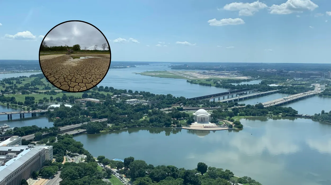
The severe weather system that swept through the Mid-Atlantic region earlier this week delivered a substantial volume of accumulation that environmental analysts state was vital for the local ecosystem. As reported by meteorologist Taylor Grenda of FOX 5, the wet weather pattern targeted areas that had been experiencing a prolonged moisture deficit.
Specifically, Grenda noted that Washington Dulles International Airport picked up nearly an inch of rainfall during the storm cycle. Furthermore, official tracking stations at Baltimore/Washington International Thurgood Marshall Airport (BWI) recorded an accumulation of more than an inch of rain.
This concentrated downpour has altered the immediate agricultural and hydrological outlook for the region. Prior to this week’s storm system, portions of the D.C.
suburbs had been trending toward severe drought thresholds, which threatened local water tables and increased suburban fire risks.
The influx of over an inch of water in key catchment areas has successfully stabilized topsoil moisture, providing what meteorologists describe as a necessary cushion before the region enters the peak heat of the summer months.
What Can Residents Expect From The Midweek Forecast?
The immediate meteorological outlook indicates that Wednesday morning commenced with clear conditions and notably cooler air, with baseline temperatures hovering in the mid-60s.
Forecasters from the FOX 5 weather team state that daytime heating will gradually push afternoon highs into the low 80s.
This trajectory is accompanied by a sustained northern breeze following the cold front, which has effectively stripped the dense humidity out of the lower atmosphere.
Looking ahead to Thursday, high pressure is projected to remain the dominant force across the eastern seaboard. Meteorologists indicate that Thursday will be slightly warmer than Wednesday, though conditions will remain highly pleasant.
The continuing presence of the high-pressure system will suppress cloud formation, ensuring that humidity levels stay low and comfortable for the duration of the day, making it the most stable period of the current workweek.
When Will Storm Risks And High Humidity Return To The Region?
The stable conditions observed during the midweek are expected to deteriorate as the region approaches the weekend. Weather monitoring data indicates that the next distinct atmospheric disturbance is scheduled to arrive on Friday afternoon.
As the high-pressure system moves offshore, a shifting wind pattern will begin drawing warm, moist air upward from the Gulf region, causing a rapid build-up of atmospheric instability.
According to the updated regional forecast, this transition will culminate in a renewed chance for isolated to scattered thunderstorms late Friday afternoon and continuing into the evening hours. Local weather authorities advise that because these storms will be fueled by rising humidity, there is a moderate probability of localized heavy downpours and gusty winds, which could impact Friday evening commuter traffic across the Interstate 95 and Interstate 495 corridors.
Will the unsettled weather persist into Saturday and Sunday?
The atmospheric instability is projected to spill over into the first half of the weekend. Atmospheric tracking shows that another round of potential storms is possible on Saturday. Meteorologists emphasize that humidity will build progressively throughout the day, creating a sticky, unstable air mass across the District.
While Sunday is currently expected to see a reduction in widespread storm activity, ambient temperatures throughout the weekend will firmly hold in the mid-to-high 80s, setting the stage for a broader climatic shift the following week.
Background Of This Particular Development
The sudden swing from severe autumnal-style downpours to high-pressure clarity is an operational characteristic of the Mid-Atlantic’s unique geographic positioning between the Appalachian Mountains and the Atlantic Ocean.
Historically, the Washington, D.C. territory relies heavily on late June frontal passages to prevent early-summer dry spells from escalating into full-scale agricultural emergencies.
The rainfall metrics recorded at Dulles and BWI this week are statistically significant because June typically represents a volatile transitional month for local water resources.
When high-pressure systems lock over the region without prior saturation—as was feared earlier this month—the resulting “heat domes” can bake the soil, rendering subsequent rains ineffective due to high runoff rates.
The timing of this severe weather stretch, despite causing temporary transit delays and localized infrastructure strain, has established a critical baseline of environmental moisture that underpins regional agricultural stability moving into the core summer season.
Prediction: How This Development Can Affect The Local Population
This meteorological sequence will directly influence the daily operations, energy consumption, and safety protocols of residents within the greater Washington metropolitan area over the coming days.
In the immediate term, the low-humidity window on Wednesday and Thursday will allow municipal outdoor maintenance crews, construction sectors, and transport authorities to accelerate infrastructure projects that were delayed by the recent rainy stretch.
Additionally, residential energy consumers will likely experience a temporary reprieve in cooling costs, as the lower humidity diminishes the immediate demand on regional electrical grids and household air conditioning systems.
However, the transition toward high humidity and storm risks on Friday and Saturday will require heightened vigilance from weekend travelers and event organizers.
The reintroduction of precipitation combined with high humidity increases the risk of sudden flash ponding on urban roadways, potentially disrupting outdoor community events.
Longer-term projections indicate that this entire cycle is the precursor to a much hotter and more oppressive stretch of weather heading into the Fourth of July holiday. With temperatures on track to surge past the 80s into the 90s by early next week, health officials are expected to issue heat advisories.
The moisture currently locked in the soil from this week’s rain will combine with the intense holiday heat to generate exceptionally high heat indices, presenting a direct risk of heat-related illness for vulnerable populations, outdoor laborers, and holiday crowds gathering for public festivities across the National Mall.