Key Points
- An intense heat dome is forecast to settle over the Mid-Atlantic region, bringing dangerous triple-digit temperatures to the Washington, D.C. metropolitan area.
- Meteorological projections indicate heat index values will exceed 100 degrees Fahrenheit (38 degrees Celsius) to 110 degrees Fahrenheit, with peak localized indices potentially reaching 115 degrees Fahrenheit.
- The weather transition begins on Tuesday with temperatures rising into the 90s, following a seasonal Monday characterized by minor morning visibility issues due to patchy fog.
- High humidity coupled with historically high overnight low temperatures in the 70s and 80s will severely limit nighttime cooling and exacerbate prolonged bodily heat stress.
- Isolated afternoon thunderstorms remain possible from Thursday through the Independence Day weekend, presenting potential disruptions to outdoor holiday activities and scheduled fireworks.
Washington (Evening Washington News) June 29, 2026 — An expansive, high-pressure atmospheric heat dome is settling across the Mid-Atlantic United States, forcing public health warnings and emergency municipal preparations across Washington, D.C., Maryland, and Virginia (DMV) as the region heads into the heavily populated Fourth of July holiday weekend. Forecasters indicate that standard seasonal conditions will rapidly deteriorate following a mild Monday, giving way to persistent triple-digit heat and suffocating humidity levels that could threaten historic regional meteorological records.
- Key Points
- Will the DMV Experience Triple-Digit Temperatures This Week?
- How High Will the Heat Index Values Reach in Washington D.C.?
- Will Holiday Fireworks and Celebrations Be Threatened by Storms?
- Why Are Meteorologists Warning That This Heat Wave Is Impactful to Everyone?
- Background of the Mid-Atlantic Extreme Heat Phenomenon
- Prediction: How the Heat Dome Will Affect Holiday Travelers and Local Commuters
Will the DMV Experience Triple-Digit Temperatures This Week?
The onset of the severe meteorological shift will follow a short window of standard seasonal summer conditions.
As detailed in public broadcasts by Meteorologist Taylor Grenda of FOX 5, Monday will remain relatively comfortable with regional high temperatures hovering safely within the 80s under mostly dry atmospheric conditions.
Commuters across the metropolitan grid experienced minor visibility constraints early on Monday due to localized patchy fog and low-lying cloud cover, though atmospheric clearing and expanding sunshine successfully restored full visibility across major transit corridors by midday.
However, this stable pattern will shift abruptly. According to regional forecast data published by Taylor Grenda of FOX 5, ambient temperatures are projected to climb steadily into the mid-90s on Tuesday.
By Wednesday, a sprawling upper-level high-pressure ridge is forecast to establish a direct foothold over the eastern seaboard, effectively locking an intense heat dome over the entire Mid-Atlantic geographical sector.
This pressure lid will trap hot air masses at the surface, driving daytime temperatures toward the 100-degree Fahrenheit mark and keeping them sustained at dangerous levels through the weekend.
How High Will the Heat Index Values Reach in Washington D.C.?
The primary danger to the public stems from the combination of extreme ambient temperatures and an influx of heavy subtropical humidity.
In an expansive national severe weather report written by the Associated Press and published by The Guardian, National Weather Service (NWS) Meteorologist Bryan Putnam stated that the high humidity arriving alongside the high-pressure system will make ambient conditions feel significantly hotter.
Bryan Putnam noted that multiple metropolitan areas across the Eastern Seaboard, including Washington, Baltimore, New York City, and Philadelphia, are positioned to experience their highest cumulative temperatures of the year so far.
The statistical reality of these combined atmospheric forces points to extreme heat index values — a metric that calculates what the temperature feels like to the human body when relative humidity is combined with air temperature.
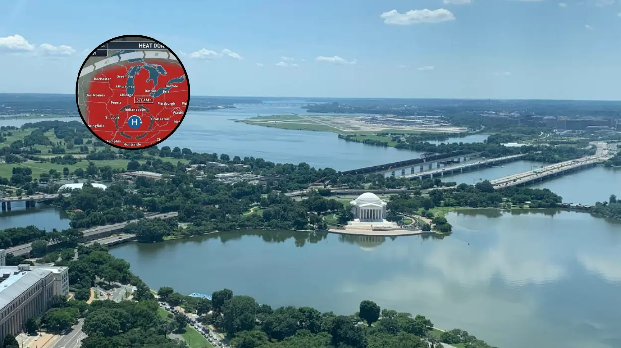
As reported by Meteorologist Taylor Grenda of FOX 5, heat index values across the DMV are expected to reliably top 100 degrees Fahrenheit.
National Weather Service Weather Prediction Center (NWS/WPC) data confirms that localized heat index values across the broader Mid-Atlantic area could surge between 100 and 110 degrees Fahrenheit, with certain dense urban centers threatening to reach localized peaks of 115 degrees Fahrenheit.
Will Holiday Fireworks and Celebrations Be Threatened by Storms?
Aside from the clear physical threat of heat exhaustion, the upcoming weather system introduces localized atmospheric instability that could alter regional holiday plans.
The mid-Atlantic forecast models indicate that the vast majority of the week will remain intensely dry, as the sinking air within the high-pressure dome acts as a physical barrier against widespread storm development.
According to analysis provided by Meteorologist Tyler Roys of AccuWeather, the high-pressure system will essentially act like a “rock” in the atmosphere, forcing major storm systems to route completely around the region and severely limiting widespread precipitation across the East Coast.
Despite this protective atmospheric barrier, the extreme surface heating will create localized instability.
As detailed by Meteorologist Taylor Grenda of FOX 5, isolated afternoon thunderstorms could begin to develop by Thursday and are expected to continue intermittently into the holiday weekend.
Forecasters emphasize that while these storms will remain isolated rather than widespread, a few convective systems are expected to form late on the Fourth of July itself.
This timing carries a high probability of disrupting late-afternoon outdoor gatherings and could potentially interfere with local municipal fireworks events if lighting or heavy downpours manifest near scheduled launch windows.
Why Are Meteorologists Warning That This Heat Wave Is Impactful to Everyone?
A critical factor separating this event from standard summer heat is its broad demographic reach and lack of nighttime relief. In the comprehensive meteorological brief compiled by the Associated Press, National Weather Service forecaster Bryan Putnam explicitly warned that this specific heat wave is “impactful to anyone.”
According to the official statement provided by Bryan Putnam of the NWS, the extreme index thresholds mean that the danger is not exclusively restricted to historically vulnerable demographics, such as older adults, young children, or individuals with pre-existing medical frailties. Instead, anyone engaging in prolonged outdoor physical exertion without strict hydration protocols faces a risk of heat-induced illness.
Compounding this baseline daytime hazard is the forecast for exceptionally high overnight minimums. Data tracking from the National Weather Service Weather Prediction Center confirms that overnight temperatures will remain unusually warm, with lows struggling to dip below the mid-to-upper 70s Fahrenheit, and remaining pinned in the low 80s within dense, concrete-heavy urban centers.
Meteorologist Tyler Roys of AccuWeather noted that for residents lacking access to structural air conditioning, these elevated night-time lows mean it will be incredibly difficult to sleep comfortably, particularly in major eastern seaboard cities.
This lack of nocturnal cooling prevents the human body from shedding accumulated daytime heat stress, dramatically compounding the physiological risks upon consecutive days of exposure.
Background of the Mid-Atlantic Extreme Heat Phenomenon
The heat wave forecasted to impact the Washington, D.C. region is part of a larger, systemic climate pattern affecting the United States in the summer of 2026.
According to meteorological records compiled by the National Weather Service and independent climate research entities, the frequency, duration, and structural intensity of high-pressure heat domes have risen steadily across the eastern two-thirds of the United States.
Climatologists attribute the increasing prevalence of these stubborn, stagnant high-pressure systems to shifting jet stream patterns, which allow hot air masses to become pinned over large geographic swaths for long periods.
This specific late-June to early-July weather pattern follows historical precedents where early-summer heat waves have severely tested regional electrical grids and public health infrastructure. In Washington, D.C., historical weather archives show that standard average high temperatures around the Fourth of July holiday typically sit near 89 degrees Fahrenheit.
The 2026 heat dome is projected to push temperatures roughly 10 to 11 degrees Fahrenheit above these established historical baselines.
Furthermore, the high moisture content drawn up from the Gulf of Mexico elevates regional dew points far beyond typical historical baselines, changing what would otherwise be a dry heat wave into an oppressive, moisture-laden event that severely restricts the natural cooling mechanism of human sweat evaporation.
Prediction: How the Heat Dome Will Affect Holiday Travelers and Local Commuters
The impending arrival of this severe heat dome is highly likely to disrupt transport networks, municipal resources, and logistical planning for hundreds of thousands of individuals across the DMV region during one of the busiest travel periods of the year.
For holiday travelers and local commuters, the prolonged triple-digit heat index will directly alter transit infrastructure efficiency. Rail transit systems, including the Washington Metropolitan Area Transit Authority (WMATA) Metro, frequently enforce speed restrictions during periods of extreme heat due to the risk of thermal expansion on steel rails, which can cause track warping. Commuters can expect localized transit delays, while motorists face an increased probability of vehicle breakdowns, tire blowouts, and engine overheating on congested highways like the I-495 Capital Beltway.
Furthermore, the timing of this heat wave over the Independence Day weekend will heavily compress attendance at traditional outdoor destinations, shifting public crowds toward indoor, air-conditioned venues or coastal waterways.
This demographic pivot is expected to create unprecedented foot-traffic strain on regional shopping malls, public libraries, and designated municipal cooling centers. Conversely, vendors, event organizers, and hospitality businesses reliant on massive outdoor foot traffic along the National Mall and surrounding historic districts may experience lower-than-anticipated daytime engagement as tourists choose to stay indoors during peak heating hours.
Public safety agencies across the District, Maryland, and Virginia are anticipated to deploy augmented emergency medical personnel to counter the predictable surge in heat-related emergency calls from tourists and residents attempting to navigate the outdoor celebrations.