
Key Points
- A cold front moving in from the west will make Wednesday breezy and more unsettled across the Washington, D.C., region.
- High temperatures are expected in the mid-70s, with increasing clouds possibly keeping readings below 80°F.
- South winds will gust up to about 30 mph during the afternoon, increasing the breezy feel.
- A first, broken line of light showers is forecast to arrive around mid-afternoon (near 3 p.m.).
- A stronger second round of showers and thunderstorms is likely this evening.
- The greatest chance for gusty or locally damaging winds is west of I‑81 and near or along the Blue Ridge, where the Storm Prediction Centre has issued a low risk outlook for severe weather.
- Storms are expected to weaken as they approach the immediate Washington area during the evening commute.
Washington (Evening Washington News) May 13, 2026 7News meteorologists report a cold front approaching from the west will make Wednesday breezy and more unsettled across the Washington metropolitan area, prompting forecasters to warn of gusty winds, two rounds of showers, and a stronger period of evening thunderstorms that could affect the evening commute.
- Key Points
- Why will temperatures climb but fail to reach 80 degrees?
- Where will winds be strongest, and what impact could they have?
- When will the showers and thunderstorms arrive, and how are they expected to behave?
- Who is most at risk for severe weather within the region?
- What should commuters and outdoor event organisers expect this evening?
- How reliable is the current forecast, and which agencies or forecasters provided these details?
- What are the expected hazards and safety guidance for residents?
- How might timing differences across the region change impacts?
- Will the storms be severe enough to prompt watches or warnings?
- What do forecasters say about the post-storm conditions and overnight expectations?
- Are there any specific travel advisories or institutional closures mentioned?
- Background of this development
- Prediction
Why will temperatures climb but fail to reach 80 degrees?
As reported by the 7News weather team, daytime highs are expected to climb into the mid-70s due to warm, southerly flow ahead of the approaching front, but increasing cloud cover through the afternoon may keep thermometers from topping out near 80°F.
The combination of warmer air aloft and cloud build-up is likely to limit surface heating, leaving much of the region with mild rather than hot conditions.
Explore More Weather News
Rain, Thunderstorms and Cooler Temps Forecast for Washington — 2026
Seattle Cloudy Friday: Drizzle, Sunbreaks, Pollen Alert – Washington 2026
Where will winds be strongest, and what impact could they have?
According to 7News, south winds will gust up to about 30 mph at times during the afternoon, which will produce a noticeably breezy day across the region and could cause minor impacts such as difficulty for high-profile vehicles on bridges and localised tree sway.
The National Weather Service’s Storm Prediction Centre has also highlighted the risk for gusty or locally damaging winds, particularly west of Interstate 81 and along the Blue Ridge, where a low risk for severe storms has been issued.
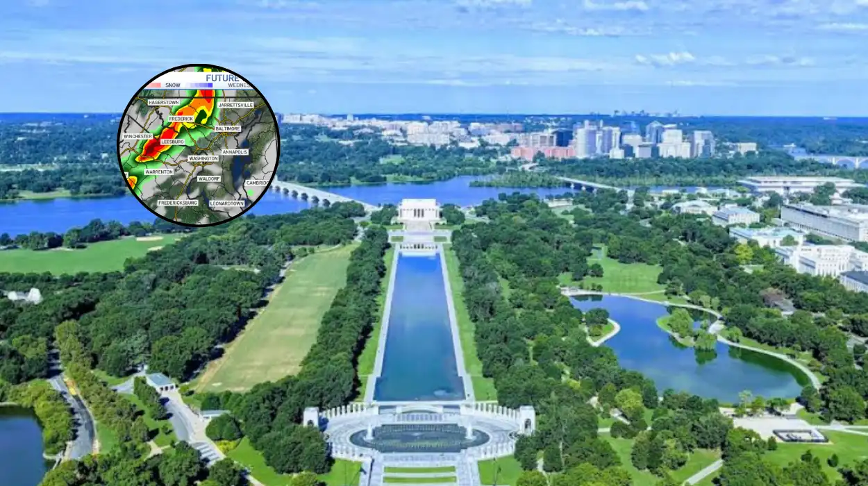
When will the showers and thunderstorms arrive, and how are they expected to behave?
Forecasters with 7News describe a two-stage precipitation scenario: the first round will arrive as a broken line of light rain in the mid-afternoon, around 3 p.m., bringing brief periods of wet roads and reduced visibility for outdoor activities; a second, stronger wave of showers and thunderstorms is forecast for the evening hours.
Meteorologists expect the second, stronger wave to be more organised and capable of stronger winds and heavier rainfall, but that storms should gradually weaken as they move eastward into the immediate Washington area during the evening commute.
Who is most at risk for severe weather within the region?
As the Storm Prediction Centre notes, the greatest risk for gusty or locally damaging winds is across the higher terrain to the west of the metro area — specifically locations west of I‑81 and along the Blue Ridge.
While the immediate Washington, D.C., urban core may see strong thunderstorms, the SPC’s low risk designation indicates widespread severe weather is not expected; instead, isolated pockets of damaging winds remain the primary concern.
What should commuters and outdoor event organisers expect this evening?
7News and national outlooks recommend that commuters prepare for an active evening commute with the potential for heavy rain and gusty winds reducing visibility and producing slippery roads, and that outdoor events scheduled for the evening monitor updates and have contingency plans.
Because storms are forecast to weaken as they move into the metro area, conditions could vary substantially across short distances, meaning one neighbourhood might see only rain while another could briefly experience stronger gusts or lightning.
How reliable is the current forecast, and which agencies or forecasters provided these details?
The primary details in this report come from the 7News weather team’s forecast bulletin and align with the Storm Prediction Centre’s regional outlook for the same period, both of which use up-to-date model guidance and surface observations to gauge storm potential and wind threat.
Local National Weather Service offices and 7News routinely combine short-range model runs, radar trends, and surface analyses to refine timing and intensity estimates for mesoscale features such as frontal passages and convective lines.
What are the expected hazards and safety guidance for residents?
Forecasters emphasise that the principal hazards are gusty winds, brief heavy rainfall, and the potential for isolated damaging wind gusts west of I‑81 and along the Blue Ridge; lightning and localised downpours are also possible with the evening thunderstorms.
Residents are advised to secure loose outdoor items, avoid travel under trees during gusty periods, and delay or move outdoor evening plans indoors if thunderstorms are approaching; drivers should reduce speed on wet roads and use headlights during low-visibility conditions.
How might timing differences across the region change impacts?
The forecast’s two-wave structure means impacts will be temporally spread: a light, scattered shower band in the mid-afternoon is likely to affect outdoor activities and late-afternoon traffic briefly, while the later, stronger round of storms in the evening will be the period with the greatest potential for heavy rainfall and gusty winds.
Because storms typically evolve and shift with mesoscale boundaries, the exact timing for any given suburb or county could be offset by an hour or more from the general timing; localised radar tracking is the best tool to follow real-time developments.
Will the storms be severe enough to prompt watches or warnings?
At the time of reporting, the Storm Prediction Centre’s outlook indicated a low risk for severe weather concentrated over higher elevation zones west of I‑81 and along the Blue Ridge, which suggests that while isolated severe storms cannot be ruled out, widespread severe watches were not expected immediately.
However, forecasters caution that if convection becomes more intense or organised than current models suggest, localised severe thunderstorm warnings could be issued by the National Weather Service for affected counties.
What do forecasters say about the post-storm conditions and overnight expectations?
7News indicates that the line of showers and thunderstorms should gradually weaken as it moves east into the immediate Washington area, leading to a reduction in intensity overnight; residual showers and cloudiness are likely to persist after the main convective activity, with cooler readings following the frontal passage.
Overnight, winds should lessen, and temperatures will fall into a cooler and less humid regime once the front passes and high pressure begins to build in the wake of the system.
Are there any specific travel advisories or institutional closures mentioned?
In the current publicly available bulletins from 7News and national outlooks, there were no immediate travel advisories or school closures reported solely in relation to this frontal passage, but local authorities and event organisers were encouraged to monitor updates and be prepared to adjust plans if stronger storms develop.
Local transit agencies often issue operational advisories in response to severe weather warnings, and commuters should check agency alerts if conditions deteriorate.
Background of this development
Why is a cold front producing this pattern now, and how typical is it for this time of year?
A cold front moving east from the continent typically produces a corridor of increasing clouds, gusty southerly winds ahead of the boundary, and convective activity (showers and thunderstorms) along and behind the front as it lifts cooler air into the region; this is a common synoptic-scale pattern in the spring and early summer months when temperature contrasts between air masses are still strong.
The Storm Prediction Centre and local forecast offices use a mixture of numerical weather prediction models, surface observations, and radar trends to time the frontal passage and convective development, which explains the two-stage expectation (initial broken light showers followed by a stronger evening round) often seen with frontal systems that encounter differing instability profiles across a region.
Prediction
Commuters should expect potentially disrupted evening travel due to heavier rain and gusty winds, so allowing extra time, checking live traffic and transit updates, and driving cautiously on wet roads are prudent steps; transit agencies may implement speed restrictions or issue advisories if visibility or wind hazards increase.
Outdoor events scheduled for late afternoon and evening should prepare contingency plans to move activities indoors or reschedule, because thunderstorms with lightning and heavy rainfall present safety hazards; residents west of I‑81 and in Blue Ridge-adjacent communities should be particularly alert to the possibility of stronger gusts and take measures to secure loose objects and check for vulnerable trees.


