A Washington State waterfalls road trip is a vehicular travel route designed to systematically visit major hydrological drops across diverse geographic regions, including the Olympic Peninsula, the Cascade Range, the Columbia River Gorge, and the arid Channeled Scablands of Eastern Washington.
- How did geological history shape Washington waterfalls?
- What are the main regions for a waterfall road trip?
- What is the optimal route for a comprehensive road trip?
- What are the key waterfall profiles on this route?
- How do seasons affect the waterfall viewing experience?
- What infrastructure and regulations apply to visitors?
- What is the long-term future of Washington watersheds?
Definition and Geographic Scope
This specific type of road itinerary outlines a driving path that connects major river systems and mountain watersheds to optimize visual and geographic access to prominent cascades. The parameters of the trip generally involve traversing several distinct eco-regions within the boundaries of Washington. Travelers navigate across changing topographies that dictate the structure and volume of each waterfall system.
The Western portion of the itinerary centers on the dense temperate rainforests of the Olympic Peninsula and the western slopes of the Cascade Range. These areas receive high annual precipitation levels, which maintain high-volume flows throughout most months of the year. The Eastern portion shifts toward volcanic plateaus and dry canyons where waterfalls exist due to ancient geological transformations rather than ongoing localized rainfall.
Hydrological and Geological Background
The presence of thousands of waterfalls in Washington is a structural consequence of the regional geology. The collision of tectonic plates created the steep gradient of the Cascade Range, providing the necessary vertical drops for falling water. At the same time, historical weather patterns and glaciation carved deep valleys that expose sheer rock faces.
Annual snowpack accumulation in high altitudes serves as the primary reservoir for these river systems. During seasonal temperature increases, the melting snow creates massive water runoff that accelerates through steep mountain channels. The underlying rock types dictate the precise shape of the drop. Basalt, an igneous rock formed from cooling lava flows, is highly prevalent in Washington and often fractures into vertical columns, creating distinct vertical plunges.
How did geological history shape Washington waterfalls?
Geological history shaped Washington waterfalls through tectonic uplift, volcanic basalt flows, and cataclysmic glacial floods that occurred over millions of years, leaving behind steep mountain gradients, fractured vertical cliffs, and deeply carved plunge pools across the state landscape.
The Role of Basalt Outcroppings
Millions of years ago, massive volcanic eruptions covered large portions of Washington in thick layers of basalt rock. This basalt cooled and hardened into dense, durable strata that resist standard water erosion more effectively than surrounding sedimentary layers. As rivers flow over these volcanic shelves, they erode the softer underlying earth, leaving behind a hard lip over which water drops.
The structural characteristic of columnar basalt forces water to sheer off sharply at right angles. This rock formation can be seen clearly at sites like Palouse Falls, where the river plunges into a deep basin surrounded by tall basalt columns. Without these ancient lava flows, the rivers would create gradual rapids instead of vertical drops.
The Impact of the Missoula Floods
During the last Ice Age, approximately 15,000 years ago, a massive glacial lake known as Lake Missoula repeatedly broke through its ice dams. These ruptures sent catastrophic walls of water rushing across Eastern Washington. The sheer volume and velocity of these floods ripped away topsoil and carved deep canyons into the solid basalt bedrock within days.
This erosional process created the Channeled Scablands and left behind stranded river valleys and dramatic drop-offs. When modern rivers settled into these paths, they met abrupt cliff edges created by the ancient floods. The Missoula Floods are entirely responsible for the dramatic, isolated topography of waterfalls found in the drier regions east of the Cascade crest.
What are the main regions for a waterfall road trip?
The main regions for a waterfall road trip include the Olympic Peninsula, the North and Central Cascades, the Columbia River Gorge, and Southwest Washington, each offering unique hydrological traits based on regional rainfall, elevation drops, and volcanic forest landscapes.
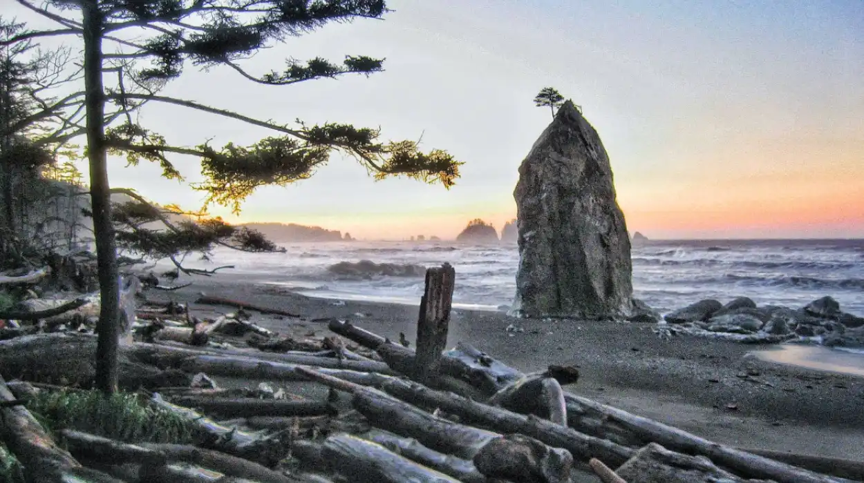
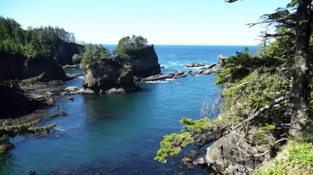
The Olympic Peninsula and Rain-Forest Drainage
The Olympic Peninsula is defined by a central mountain mass surrounded by low-lying coastal plains. This region receives some of the highest rainfall totals in North America, often exceeding 140 inches annually in areas like the Hoh Rain Forest. This constant water input feeds stable, perennial river systems that move through dense temperate forests.
Waterfalls in this zone are characterized by moss-covered rock faces, surrounding old-growth timber, and consistent year-round water volume. The low elevation of the trailheads means these routes remain free of heavy snowpack for most of the year. This accessibility allows for predictable driving and hiking conditions across seasons.
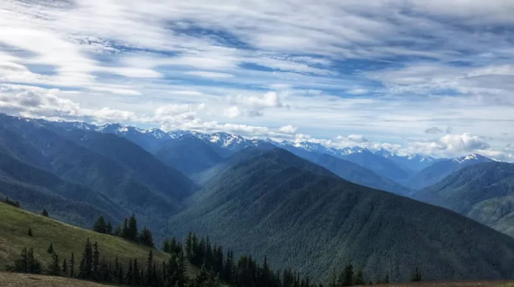
The Cascade Range Mountain Passes
The Cascade Range forms a vertical spine through the center of the state, dividing the wet western lowlands from the arid eastern plains. The steep alpine topography creates waterfalls with significant vertical drops, often sourced directly from high-altitude glaciers or seasonal snowmelt fields.
Because these systems rely heavily on high-elevation snowpack, their flow volumes change dramatically depending on the month. Peak discharge occurs during late spring and early summer when rising temperatures accelerate snowmelt. Many of these falls are located along major mountain passes, making them highly accessible from primary state highways.
The Columbia River Gorge Structural Corridor
The Columbia River Gorge is a deep canyon that cuts directly through the Cascade Range at sea level. The south-facing cliffs on the Washington side of the river feature numerous waterfalls that drop from the high forested plateaus down toward the main river channel.
The unique wind patterns and steep cliffs of the gorge create distinct microclimates. The waterfalls here drop over basalt shelves into rocky gorges surrounded by bigleaf maple and Douglas fir trees. Highway 14 provides direct access to these sites, aligning with historic transit routes through the region.
What is the optimal route for a comprehensive road trip?
The optimal route for a comprehensive road trip begins on the Olympic Peninsula, crosses Puget Sound via ferry, follows Highway 2 and Interstate 90 through the Cascades, and concludes by moving south toward the Columbia River Gorge highway corridor.
Segment One: The Olympic Peninsula Circuit
The journey starts by driving US Route 101 clockwise around the Olympic National Park perimeter. This section targets the coastal rivers and lowland rainforest valleys. Key stops involve short trail walks through dense forest to view drops that terminate in rocky creek beds.
Drivers move through towns like Port Angeles and Forks, utilizing well-marked national park access roads. This segment requires a national park pass for vehicle entry at specific trailheads, and the driving surfaces are paved, low-elevation state routes.
Segment Two: The Cascade Highway Crossings
After completing the Olympic loop, travelers utilize the Edmonds-Kingston ferry to cross Puget Sound and access US Route 2, also known as the Stevens Pass Highway. This road climbs rapidly into the western slopes of the Cascades, tracing the Skykomish River valley.
From Stevens Pass, the route hooks south toward Interstate 90 via regional highways to access the central Cascade waterfalls. This segment features steep mountain driving, multiple runaway truck ramps, and dramatic elevation changes that require sound vehicle brakes and attentive mountain driving techniques.
Segment Three: The Southern Columbia Gorge and Eastern Border
The final leg moves south along the eastern flank of the mountains or down the Interstate 5 corridor to meet State Route 14 along the Columbia River. This highway runs parallel to the river, offering views of the gorge walls and access to the tributaries feeding the Columbia.
For a complete hydrological survey, travelers can extend the route northeast via US Route 395 into the desert landscapes to view the isolated canyon plunges. This final transition highlights the stark geographic contrast between the forested coastal zones and the barren volcanic plateaus of the interior.
What are the key waterfall profiles on this route?
The key waterfall profiles on this route include Snoqualmie Falls, Marymere Falls, Palouse Falls, and Lewis River Falls, which represent four distinct structural categories based on volume, height, drop mechanics, and surrounding rock formations.
Snoqualmie Falls: The High-Volume Plunge
Located in the foothills of the central Cascades, Snoqualmie Falls drops 268 feet over a sheer basalt cliff. It is one of the most visited natural sites in the state due to its proximity to the Seattle metropolitan area. The flow is managed partly by a subterranean hydroelectric power facility operated by Puget Sound Energy.
The waterfall exhibits a classic plunge structure, where the water drops vertically without hitting the rock wall during its descent. A large, deep plunge pool sits at the base, surrounded by high granite and basalt canyon walls that trap a constant mist in the immediate vicinity.
Marymere Falls: The Forested Ribbon
Marymere Falls is situated near Lake Crescent on the Olympic Peninsula. It features a total drop of 90 feet, falling in a slender, ribbon-like structure down a steep cliff face covered in moss, ferns, and small shrubs. The water originates from Falls Creek and flows through an old-growth forest of cedar and hemlock.
The approach trail requires a 1.8-mile round-trip walk that crosses two wooden bridges over Barnes Creek. The infrastructure includes engineered wooden viewing platforms built at two distinct elevations to allow travelers to view both the lower pool and the upper drop safely.
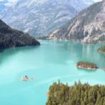
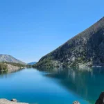
Palouse Falls: The Desert Canyon Drop
Palouse Falls is designated as the official state waterfall of Washington. Located in a remote state park in southeastern Washington, it drops 198 feet into a swirling basalt canyon basin. The surrounding landscape consists of barren, grassy hills and exposed rock layers carved by ice-age floods.
The site is historically significant to the Palouse Native American tribe and represents a unique desert hydrological ecosystem. Due to extreme canyon drops and loose gravel trails, viewing is strictly restricted to designated fenced overlooks to ensure visitor safety.
Lewis River Falls: The Wide Tiered Cascade
Located in the Gifford Pinchot National Forest, the Lewis River waterfall system consists of three distinct sections: Upper, Middle, and Lower Lewis River Falls. Lower Lewis River Falls is the most prominent, measuring 200 feet wide across a broad basalt shelf while dropping only 43 feet vertically.
This structure forms a wide curtain of water rather than a single narrow stream. The river below the falls creates a wide emerald pool that is highly popular during warm summer periods. Access requires driving on forest service roads that are typically closed by snow from late November through April.
How do seasons affect the waterfall viewing experience?
Seasons affect the waterfall viewing experience by dictating water volume, road accessibility, and trail safety, with spring offering maximum water flows, summer providing reliable road conditions, and winter introducing ice formations and seasonal road closures.
Spring Peak Flow Mechanics
During the spring months, specifically from late April through June, rising ambient temperatures melt the winter snow accumulation in the mountains. This meltwater enters the river systems rapidly, causing rivers to reach their highest annual discharge rates. Waterfalls during this phase appear wide, powerful, and turbulent.
The downside to spring viewing is the presence of heavy mist, which can obscure visibility from close overlooks. Additionally, high-altitude trails may still be covered in hard, slippery snowpack, requiring specialized footwear traction devices like microspikes to safely navigate the approaches.
Summer Access and Clarity
Summer brings stable weather, clear skies, and dry driving surfaces across all mountain passes. Water volumes decrease from their spring peaks, revealing the underlying rock structures and artistic basalt columns that are normally hidden behind walls of chaotic white water.
The water clarity increases significantly in late summer because the absence of rapid mud runoff allows alpine minerals to color the pools a deep blue or emerald green. This season is ideal for photography and swimming in designated safe lower pools, though popular sites experience heavy vehicle congestion.
Autumn and Winter Alterations
Autumn introduces changing foliage colors, with bigleaf maples turning bright yellow against the dark green evergreen background. This period represents the lowest natural water flow of the year before the winter rain cycles begin.
Winter completely transforms the waterfalls. In freezing temperatures, spray mist freezes onto surrounding cliffs and railings, creating massive ice walls and delicate icicle formations. However, mountain passes experience frequent closures due to avalanche hazards, and many unmaintained forest roads become completely impassable to standard passenger vehicles.
What infrastructure and regulations apply to visitors?
The infrastructure and regulations applying to visitors include vehicle parking passes like the Discover Pass and Northwest Forest Pass, strict wilderness trail safety protocols, and structural viewing platforms managed by state and federal conservation agencies.
Required Parking Passes and Permits
Washington lands are divided among multiple management agencies, each requiring distinct vehicle parking passes. The Discover Pass is mandatory for all state-managed lands, including state parks and natural resource conservation areas. Federal lands require separate documentation.
- Discover Pass: Valid for Washington State Parks and Department of Natural Resources lands.
- Northwest Forest Pass: Valid for United States Forest Service trailheads in national forests.
- America the Beautiful Interagency Pass: Covers all federal fee areas, including National Parks and Forest Service sites.
Failure to display these passes clearly on a vehicle’s rearview mirror or dashboard results in financial citations issued by park rangers. Most major trailheads have automated electronic kiosks to purchase day-use passes before starting a hike.
Trail Safety and Environmental Protection
Waterfall environments are hazardous due to slippery rock surfaces, steep drop-offs, and swift underwater currents. Staying on designated, engineered boardwalks and trails prevents accidental falls and minimizes soil erosion. The spray from waterfalls keeps the surrounding soil saturated, making off-trail slopes unstable and prone to mudslides.
Visitors must practice Leave No Trace principles to protect these sensitive riparian zones. This includes packing out all garbage, keeping domestic pets on secure leashes, and avoiding the disturbance of local wildlife species like mountain goats, dippers, and salmon pools.
What is the long-term future of Washington watersheds?
The long-term future of Washington watersheds depends on shifting climate patterns that alter winter snowpack retention, increase the frequency of severe summer droughts, and accelerate structural rock erosion along major river corridors.
Climate Shifts and Snowpack Reduction
Scientific data from environmental agencies shows a gradual warming trend that impacts winter snow accumulation. Higher temperatures cause a larger percentage of winter precipitation to fall as rain rather than snow at mid-elevations. This reduces the total volume of the summer snowpack reservoir.
The implication for waterfalls is a shift in seasonal flow timing. Spring runoffs occur earlier in the calendar year, leading to diminished water flows in late summer and early autumn. Some minor ephemeral waterfalls, which currently flow through July, may dry up completely by mid-summer in future decades.
Geomorphological Changes and Public Safety
Waterfalls are dynamic geological features that continuously alter their landscape. The constant force of pounding water erodes the plunge pool basin and undercuts the cliff face over time. This undercutting eventually causes the top rock shelf to collapse under its own weight, moving the waterfall upstream.
These natural structural failures present challenges for public park infrastructure. Rockfalls can destroy viewing platforms, footbridges, and established trail routes. Management agencies must continuously monitor cliff stability and periodically relocate viewing areas to ensure long-term public safety along the routes.