The Cascade Loop National Scenic Byway is a 440-mile highway circuit that circles through the northern Cascade Mountains, the semi-arid Columbia River Basin, and the coastal marine environments of the Puget Sound in Washington State.
- What Is the Cascade Loop Scenic Byway?
- When Was the Cascade Loop Road Route Established?
- What Are the Key Regions and Mileage Segments Along the Route?
- How Long Does It Take to Complete the Drive?
- What Seasonal Closures Impact the Cascade Loop?
- What Are the Primary Ecological and Conservation Impacts of the Route?
- What Are the Essential Practical Logistics for Travelers?
- How Does the Loop Support Regional Economies?
What Is the Cascade Loop Scenic Byway?
The Cascade Loop Scenic Byway is a federally designated 440-mile National Scenic Byway that forms a continuous driving circuit through northern Washington. The route traverses nine distinct ecological regions, crossing two major mountain passes and connecting coastal waterways with interior desert valleys.
Core Highway Architecture
The physical infrastructure of the circuit relies on eight connected public highway segments maintained by the Washington State Department of Transportation (WSDOT). The route starts 25 miles north of Seattle in Snohomish County and tracks eastward via US Highway 2 over Stevens Pass, which sits at an elevation of 4,061 feet. It then descends into the Wenatchee River Valley and follows US Highway 97 Alternate and US Highway 97 northward along the Columbia River and Lake Chelan.
The loop shifts westward by utilizing State Route 153 through the Methow Valley, linking directly to State Route 20, also known as the North Cascades Highway. This mountain highway reaches its apex at Washington Pass at 5,477 feet before dropping into the Skagit Valley. The westernmost section incorporates State Route 525 across Whidbey Island, completing the loop via the Mukilteo-Clinton segment of the Washington State Ferries system.
Ecological and Geographic Diversity
Travelers move through sharp climatic transitions due to the rain shadow effect created by the Cascade Range. The western slope features marine estuaries and dense temperate rainforests dominated by old-growth conifers like Western Red Cedar (Thuja plicata) and Douglas-fir (Pseudotsuga menziesii).
Upon crossing the mountain crest, the landscape transitions into a semi-arid shrub-steppe environment in Eastern Washington, characterized by big sagebrush (Artemisia tridentata) and an average annual precipitation of less than 10 inches in areas like Wenatchee.
When Was the Cascade Loop Road Route Established?
The Cascade Loop was officially organized as a unified tourist route in 1978 following the completion of the North Cascades Highway segment of State Route 20 in 1972. The route achieved formal National Scenic Byway status from the Federal Highway Administration in 2021.
Historical Overpass Infrastructure
Prior to the late nineteenth century, the rugged topography of the northern Cascades was navigated exclusively via indigenous trading paths and mining footpaths. The earliest mechanized infrastructure began with the Great Northern Railway, which established a rail line over Stevens Pass in 1893 to connect the Puget Sound with eastern markets. This rail corridor laid the groundwork for the construction of a primitive automobile road over Stevens Pass, which opened to public traffic in 1925.
The northern half of the loop remained disconnected for decades due to the extreme terrain of the upper Skagit and Methow river systems. The Washington State Legislature approved initial exploration funds of $30,000 in 1895, but structural work did not begin in earnest until 1958.
The final connection required 14 years of heavy engineering through solid granite, culminating in the opening of the North Cascades Highway on September 2, 1972. This road successfully joined the isolated communities of Marblemount and Mazama.
Formal Designations and Economic Evolution
Recognizing the economic potential of a continuous circle route, local stakeholders formed the non-profit Cascade Loop Association in 1978 to manage regional marketing and infrastructure planning. The corridor received state-level recognition as a Washington State Scenic and Recreational Highway.
The Federal Highway Administration granted the route its National Scenic Byway designation in 1921 based on its outstanding scenic, historical, and recreational qualities. This federal status unlocked specialized grants for conservation and infrastructure development along the corridor.
What Are the Key Regions and Mileage Segments Along the Route?
The Cascade Loop consists of nine geographic regions spanning 440 miles of continuous roadway. The route begins at the Puget Sound coastline, ascends into alpine corridors, transitions into desert river valleys, and returns westward through agricultural lowlands and marine islands.
The Western Ascents: Snohomish River Valley and Stevens Pass Greenway
The loop begins at sea level in the urban centers of Mukilteo and Everett. This initial 30-mile segment tracks through the Snohomish River Valley, an alluvial plain dominated by agricultural fields and secondary-growth deciduous forests.
As the route transitions onto westbound US Highway 2, it transforms into the Stevens Pass Greenway. This 50-mile mountain corridor follows the path of the Skykomish River, climbing steadily past the rural communities of Sultan, Gold Bar, and Index.
The roadway features steep vertical canyon walls, providing direct access to prominent geological sites such as the 265-foot multi-tiered drop of Wallace Falls and the sheer granite face of Mount Index.
The Eastern Valleys: Leavenworth, Wenatchee, and Lake Chelan
At the summit of Stevens Pass, the highway crosses the crest of the Cascade Range and descends into the Leavenworth and Cascade Foothills region. This area is anchored by the municipality of Leavenworth, an alpine village structurally remodeled in the 1960s to mimic Bavarian architecture as a community stabilization strategy.
Continuing 22 miles southeast, the loop meets the Columbia River at Wenatchee, a major agricultural hub designated as the “Apple Capital of the World.”
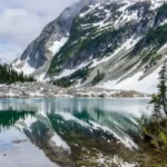
The route then turns north along US Highway 97 Alternate for 38 miles to reach the Lake Chelan Valley. This deep, glacier-carved fjord extends 50.5 miles into the wilderness, reaching depths of 1,486 feet, making it the third-deepest lake in the United States.
The Northern Wilds: Methow Valley and North Cascades Highway
From the town of Chelan, the route runs north to Pateros, where it transitions onto State Route 153 along the Methow River. This 40-mile section provides entry into the Methow Valley, an arid basin characterized by western-themed architecture in towns like Winthrop.
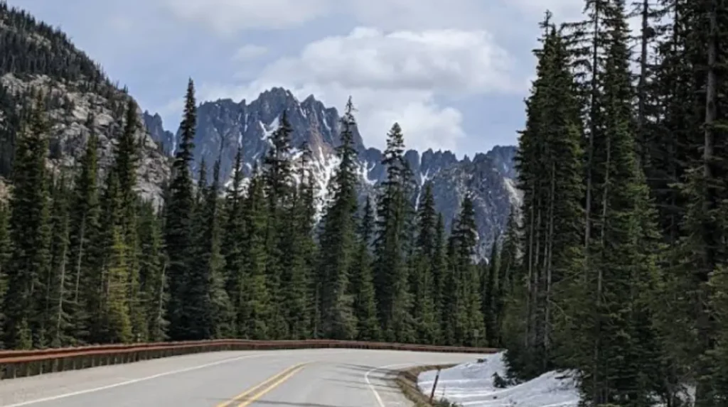
At Mazama, the road merges into the high alpine segment of State Route 20. This 75-mile mountain highway cuts directly through North Cascades National Park, passing beneath the 7,720-foot granite monolith of Liberty Bell Mountain.
The highway peaks at Washington Pass before dropping rapidly past the turquoise waters of Diablo Lake and Ross Lake, which owe their distinct coloration to suspended glacial flour (fine rock particles ground by moving glaciers).
The Coastal Return: Skagit Valley and Whidbey Island
The western descent terminates in the Skagit Valley, an agricultural floodplain that produces approximately 75% of the commercial spinach seed grown in the United States. The route tracks west toward Fidalgo Island and crosses over Deception Pass via the 180-foot-tall steel cantilever Deception Pass Bridge, constructed in 1935.
The final 55-mile driving stretch moves south down the spine of Whidbey Island along State Route 525. This segment preserves historic agricultural landscapes within Ebey’s Landing National Historical Reserve.
The circuit closes at the Clinton ferry terminal, where travelers board a Washington State Ferry for a 20-minute crossing back to the starting point in Mukilteo.
Explore More Things to do
Diablo Lake Washington: Turquoise Viewpoints, Trails & Best Time
North Cascades National Park Guide: Ultimate Alpine Adventure for Washington Visitors
How Long Does It Take to Complete the Drive?
Completing the 440-mile Cascade Loop requires a minimum of 10 to 12 hours of continuous, non-stop driving time under optimal road conditions. Travel experts recommend a duration of 3 to 5 days to safely account for terrain changes and recreational stops.
Baseline Transit Metrics
A single-day transit of the entire loop is logistically possible but highly restrictive due to low speed limits, mountain grades, and ferry schedules. The average speed limit across the mountain passes and rural island highways ranges between 35 and 55 miles per hour.
The maritime component between Clinton and Mukilteo introduces mandatory wait times; the ferry operates on 30-minute intervals during peak hours, but vehicle queues during summer weekends can extend total transit times by 1 to 2 hours.
Recommended Seasonal Multi-Day Itineraries
To properly absorb the geographical regions without driver fatigue, travelers generally divide the route into multi-day segments. A standardized 4-day itinerary allocates specific regions to distinct travel blocks:
- Day 1: Seattle/Mukilteo to Leavenworth via US Highway 2 (85 miles), focusing on the Skykomish River valley hikes.
- Day 2: Leavenworth to Lake Chelan via Wenatchee (60 miles), prioritizing vineyard tours and agricultural stops.
- Day 3: Lake Chelan to Winthrop via the Methow Valley (75 miles), traversing the western-themed historic towns.
- Day 4: Winthrop to Mukilteo via the North Cascades Highway and Whidbey Island (220 miles), including the ferry transit.
What Seasonal Closures Impact the Cascade Loop?
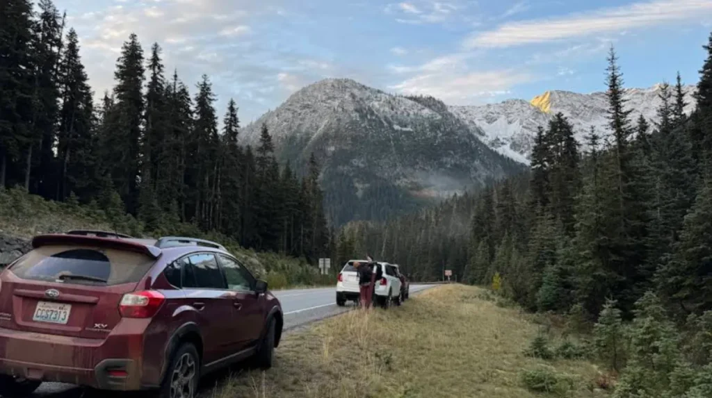
The northern section of the Cascade Loop along State Route 20 closes completely to vehicular traffic during the winter season due to extreme avalanche risk. The remaining segments of the loop stay open year-round but require specialized winter traction equipment.
The North Cascades Highway Winter Closure Mechanism
WSDOT enacts a mandatory winter closure on a 37-mile stretch of State Route 20 between Milepost 134 (near Diablo) and Milepost 171 (near Mazama). This specific alpine zone contains over 30 established avalanche paths that routinely deposit up to 20 feet of snow on the roadway.
The closure typically begins between mid-November and early December, depending on snow accumulation rates. The road remains closed to all automobile traffic until spring clearing operations conclude, which generally occurs between mid-April and early May.
During this winter window, the Cascade Loop cannot be completed as a continuous circuit. Drivers must utilize Interstate 90 or US Highway 2 as alternative trans-cascade corridors.
Year-Round Infrastructure Maintenance
The southern mountain crossing on US Highway 2 over Stevens Pass remains open year-round to facilitate interstate commerce. However, this pass is subject to temporary closures for active avalanche control and snow removal conducted by WSDOT crews using rotary snowplows and explosive charges.
Washington State law (RCW 46.37.510) requires all vehicles navigating the mountain passes between November 1 and April 1 to carry approved traction devices, such as tire chains or studded tires.
What Are the Primary Ecological and Conservation Impacts of the Route?
The Cascade Loop intersects fragile subalpine ecosystems, critical agricultural watersheds, and protected marine environments. The high volume of seasonal vehicular traffic creates documented challenges for wildlife migration, carbon emissions, and local resource management.
Wildlife Corridor Fragmentation and Mitigation
The highway infrastructure cuts directly through the migration corridors of several large mammal species. These include the Rocky Mountain elk (Cervus canadensis nelsoni), mule deer (Odocoileus hemionus), and the endangered gray wolf (Canis lupus).
Vehicular collisions present a persistent safety hazard. To mitigate this fragmentation, the Washington State Department of Fish and Wildlife (WDFW) and WSDOT have collaborated to install wildlife-exclusion fencing and specialized underpasses. These structures allow animals to cross beneath the road surface without disrupting traffic flow.
Transition to Electric Vehicle Infrastructure
To address the carbon footprint generated by internal combustion vehicles traversing the scenic loop, a major infrastructure initiative was executed between 2012 and 2015. WSDOT partnered with Plug-In North Central Washington to construct a network of 32 electric vehicle (EV) charging stations.
These charging sites are strategically spaced 25 to 50 miles apart along the entire 440-mile loop, making the Cascade Loop one of the earliest fully designated “Electric Byways” in the United States. This infrastructure supports modern long-range battery electric vehicles, reducing direct tailpipe emissions within North Cascades National Park and surrounding national forests.
What Are the Essential Practical Logistics for Travelers?
Executing a successful road trip along the Cascade Loop requires securing appropriate public land parking passes, tracking seasonal ferry schedules, and arranging advanced lodging reservations during peak summer months.
Required Land Management Permits
Because the route crosses multiple federal, state, and local jurisdictions, drivers must obtain specific land-use passes to park at trailheads and scenic viewpoints.
- Discover Pass: A mandatory state vehicle pass required for entry into all Washington State Parks, including Wallace Falls, Lake Wenatchee, and Deception Pass.
- Northwest Forest Pass: A federal permit required at designated trailheads within the Mount Baker-Snoqualmie and Okanogan-Wenatchee National Forests.
- America the Beautiful Pass: A comprehensive federal interagency pass that covers entry to North Cascades National Park and satisfies all Northwest Forest Pass requirements.
Fuel and Charging Availability
Fuel stations are widely available along the western Interstate 5 corridor and the urban centers of Eastern Washington like Wenatchee. However, fuel availability drops sharply along the North Cascades Highway segment of State Route 20.
There are no commercial fuel services on the 70-mile stretch between Marblemount and Mazama. Drivers must verify their fuel levels or battery charge states before entering this remote mountain pass area.
How Does the Loop Support Regional Economies?
The Cascade Loop functions as a vital economic engine for rural Washington communities, generating millions of dollars annually through seasonal tourism, hospitality, agricultural sales, and outdoor recreation expenditures.
Tourism and Hospitality Metrics
The economic impact of the loop is heavily tied to small-town business ecosystems that rely on highway traffic. According to data from Dean Runyan Associates, travel spending in counties along the loop (Snohomish, Chelan, Okanogan, Skagit, and Island) contributes significantly to local tax bases.
In rural Okanogan County, tourism spending accounts for a substantial percentage of total employment, particularly during the summer operating window of the North Cascades Highway.
Agricultural Synergy
The route directly connects consumers with regional agricultural producers. It guides travelers past the apple and pear orchards of the Wenatchee Valley, the estate wineries of the Lake Chelan American Viticultural Area (AVA), and the sprawling berry and tulip fields of the Skagit Valley.
This direct vehicular access drives farm-gate sales at roadside stands, tasting rooms, and local farmers markets. These activities help diversify the income streams of family-owned agricultural enterprises along the corridor.
How long is the Cascade Loop Scenic Byway?
The Cascade Loop Scenic Byway is approximately 440 miles long. It forms a circular driving route through northern Washington, connecting mountain passes, river valleys, agricultural regions, coastal communities, and island landscapes.