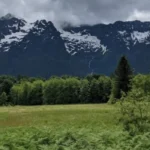
North Cascades National Park, established by Congress in 1968, spans over 500,000 acres of protected wilderness in northern Washington. The park complex contains over 300 glaciers, making it the most heavily glaciated area in the United States outside of Alaska. The National Park Service manages 400 miles of hiking trails across this landscape, which features elevation profiles ranging from temperate river valleys to high alpine zones. This geographic variety requires comprehensive navigation and planning because the terrain presents variable climate conditions, steep topographical changes, and distinct microclimates across the eastern and western slopes of the Cascade Range.
- What is the history of the North Cascades National Park trail system?
- What are the best day hiking trails in North Cascades National Park?
- What are the most challenging backpacking routes in the park?
- What permit and safety regulations govern North Cascades hiking?
- How does seasonal weather affect trail accessibility?
- What ecological zones do hikers encounter across the park?
- What are the long-term impacts of climate change on these trails?
- How should hikers prepare for the unique demands of the North Cascades?
What is the history of the North Cascades National Park trail system?
The North Cascades National Park trail system developed from indigenous trading routes, 19th-century mining pathways, and early 20th-century federal conservation infrastructure. Indigenous populations utilized these low-elevation valleys for thousands of years prior to formalized resource extraction and federal wilderness designation.
Indigenous trade routes
Prior to Euro-American exploration, indigenous peoples utilized the natural geographic corridors of the North Cascades for seasonal hunting, foraging, and trans-cascade trade. The Upper Skagit, Sauk-Suiattle, Nlaka’pamux, and Syilx nations traveled through mountain passes to exchange coastal resources, such as marine oils and dried shellfish, for interior items like obsidian, hemp, and huckleberries. These seasonal paths formed the precise geographic baselines for modern corridors, including parts of the modern Pacific Crest Trail and Cascade Pass Trail.
Resource extraction pathways
The formalization of permanent trails accelerated during the mid-19th century due to resource extraction. The discovery of gold, silver, and lead in regions like the Stehekin Valley, Horseshoe Basin, and Ruby Creek brought thousands of prospectors to the mountains between 1870 and 1900. Miners cleared rough pack-horse trails through dense river valleys to transport machinery and ore. Towns like Mineral Park and Gilbert emerged and collapsed, leaving behind graded routes that the United States Forest Service later integrated into its early administrative network.
Federal infrastructure and conservation
The United States Forest Service assumed management of the region under the Washington Forest Reserve in 1897, establishing fire lookouts and ranger patrol trails during the 1920s and 1930s. The Civilian Conservation Corps constructed campgrounds, bridges, and trail networks to expand public access. The passage of the North Cascades National Park Act on October 2, 1968, transferred administration to the National Park Service, shifts priority from timber extraction to wilderness preservation, and stabilized the current 400-mile trail inventory.
What are the best day hiking trails in North Cascades National Park?
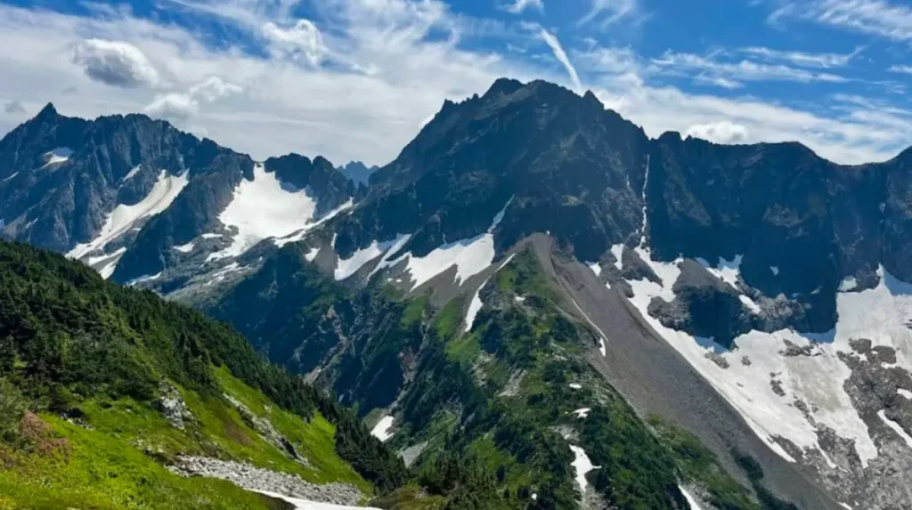
The best day hiking trails in North Cascades National Park include Cascade Pass, Maple Pass Loop, Blue Lake, and Sahale Arm. These routes provide direct access to alpine environments, subalpine larch forests, glacial cirques, and panoramic vistas along the State Route 20 corridor.
Cascade Pass Trail
The Cascade Pass Trail is a 7.4-mile round-trip route that features 1,700 feet of elevation gain. The trail begins at the end of Cascade River Road and climbs through 30 forested switchbacks to an alpine pass at 5,392 feet. This path serves as the central artery for high-alpine travel in the park, providing views of Johannesberg Mountain, Mix-up Peak, and the massive glaciers of the Cascade Pass cirque. The well-graded path consists of packed dirt and rock, making it the most accessible alpine vantage point in the park complex.
Maple Pass Loop
The Maple Pass Loop is a 7.2-mile subalpine circuit located at Rainy Pass along State Route 20, featuring 2,200 feet of elevation gain. The trail climbs along a steep ridgeline, offering uninterrupted views of Lake Ann, Rainy Lake, and the surrounding peaks of the Okanogan-Wenatchee National Forest. Hikers navigate a landscape dominated by subalpine fir, mountain hemlock, and alpine meadows. The loop can be hiked in either direction, though a counter-clockwise approach provides a more gradual ascent with expansive views of Frisco Mountain and the early autumn coloration of alpine larches.
Blue Lake Trail
The Blue Lake Trail is a moderate 4.6-mile round-trip hike with 915 feet of vertical gain, starting at an elevation of 5,150 feet. The route winds through subalpine forests and granite boulder fields to reach a tarn situated directly beneath the vertical walls of Early Winters Spires and Cutthroat Peak. The lake features clear, cold water fed by snowmelt, and the shoreline contains pockets of subalpine larches that turn gold in late September. This trail serves as a popular approach route for rock climbers targeting the classic alpine routes on the Liberty Bell Mountain group.
Sahale Arm Trail
The Sahale Arm Trail extends from Cascade Pass, adding 4.8 miles and 2,263 feet of elevation gain to the baseline Cascade Pass hike, culminating at 7,550 feet. The path climbs out of the pass through subalpine meadows where marmots, pika, and mountain goats frequently feed. The final mile crosses a steep moraine of loose talus and scree before terminating at the base of the Sahale Glacier. This route provides panoramic views of Doubtful Lake, the Stehekin River Valley, and dozens of glaciated peaks extending southward toward Glacier Peak.
What are the most challenging backpacking routes in the park?
The most challenging backpacking routes in North Cascades National Park include the Copper Ridge Loop, the Picket Range traverses, and the Ptarmigan Traverse. These multi-day journeys require remote wilderness navigation, significant cumulative elevation changes, glacier travel skills, and formal backcountry permits.
Copper Ridge Loop
The Copper Ridge Loop is a 34-mile backcountry circuit located in the northern wilderness of the park, requiring multiple days to complete. The route begins at the Hannegan Pass Trailhead, climbing over Hannegan Pass before splitting onto the ridge trail or descending into the Chilliwack River Valley. Backpackers experience a mixture of high, exposed ridgelines with expansive views of Mount Baker and the Picket Range, alongside dense, old-growth river bottoms. The route features a unique hand-operated cable car crossing over the Chilliwack River, which requires physical strength and careful coordination to operate safely with heavy packs.
The Picket Range Traverses
The Picket Range represents the most rugged, inaccessible sub-range within the North Cascades, split into the Northern Pickets and Southern Pickets. Traversing this region involves no maintained trails, requiring backpackers to navigate via route-finding across steep heather, exposed class 3 and 4 rock scrambling, and broken glaciers. Common entry points include the Access Creek or Thornton Lakes drainages, leading to high camps such as Perfect Pass or the Chopping Block. These traverses demand extensive experience with mountaineering equipment, including ropes, ice axes, and crampons, to manage the objective hazards of rockfall and crevasse crossings.
The Ptarmigan Traverse
The Ptarmigan Traverse is a classic 30-mile alpine mountaineering route that stays almost entirely above the tree line between Cascade Pass and Cub Basin. This route crosses five major glaciers, including the Cache, Spider, Dana, Le Conte, and South Cascade glaciers. Backpackers must navigate complex crevasse fields, high mountain passes, and steep snow couloirs while carrying self-arrest tools and crevasse rescue gear. Completion of the traverse typically takes 4 to 6 days, depending on weather clarity, and demands advanced proficiency in alpine navigation, weather forecasting, and snow physics.
What permit and safety regulations govern North Cascades hiking?
North Cascades hiking is governed by mandatory National Park Service backcountry permits for overnight stays, specific parking pass requirements at trailheads, and strict wilderness safety regulations. These rules preserve the fragile alpine ecosystem and manage risks associated with wilderness travel.
Backcountry permit system
The National Park Service requires a wilderness permit for all overnight stays within the North Cascades National Park Service Complex. This complex includes the national park, Ross Lake National Recreation Area, and Lake Chelan National Recreation Area. Permits must be obtained through the Recreation.gov digital lottery system or via limited walk-up availability at the Wilderness Information Center in Marblemount. The park utilizes a strict zone capacity system to prevent overcrowding, specifying exact campsites or cross-country zones where backpackers must camp each night of their itinerary.
Vehicle parking passes
Trailheads throughout the North Cascades require different vehicle passes depending on the specific land management agency responsible for the parking area. The federal interagency pass, known as the America the Beautiful Pass, or the regional Northwest Forest Pass is mandatory at US Forest Service trailheads, such as Maple Pass and Blue Lake. Within the national park boundaries, parking at National Park Service trailheads, including Cascade Pass, does not require a parking fee. Visitors must verify the specific administrative status of their chosen trailhead to avoid citations.
Wildlife and safety regulations
The North Cascades ecosystem contains large predators, including black bears, cougars, and occasional grizzly bears. The park mandates the use of approved, hard-sided bear canisters or the proper hanging of food at all backcountry camps to prevent wildlife habituation. Mountain goats inhabit high alpine areas like Sahale Arm; regulations require hikers to maintain a minimum distance of 50 yards from goats to prevent defensive behavior. Additionally, parties traveling in groups larger than 12 individuals are prohibited on park trails to minimize physical impacts on delicate alpine heather and tundra vegetation.
How does seasonal weather affect trail accessibility?
Seasonal weather affects trail accessibility by restricting vehicle travel via winter snow accumulation, creating avalanche hazards during spring thaws, and introducing wildfire smoke risks in late summer. The optimal hiking window occurs from early July through mid-October.
Winter closures and snowpack
Winter snow accumulation routinely closes State Route 20, also known as the North Cascades Highway, between Milepost 134 and Milepost 171 from late November until May or June. Snow depths at higher elevations can exceed 15 to 20 feet, burying trailheads and making trails inaccessible without advanced winter travel skills. Unpaved access roads, including the Cascade River Road and the Thornton Lakes Road, sustain routine damage from winter washouts and remain blocked by snowdrifts long after the main highway reopens.
Spring melt and avalanche hazards
During the spring transition from May through June, rising temperatures initiate snowmelt, which creates dynamic wilderness hazards. Snow bridges over roaring mountain creeks become unstable and prone to sudden collapse under a hiker’s weight. High-elevation slopes retain significant snowpacks that present wet-loose and glide-crack avalanche hazards across popular paths like Cascade Pass. Hikers during this period require ice axes, traction devices, and avalanche safety gear to navigate the steep, snow-covered terrain safely.
Summer conditions and wildfire season
The peak hiking season runs from July through September, when trails are clear of snow and alpine wildflowers bloom in the meadows. However, late August and September bring a rising risk of wildfires caused by lightning strikes or human activity. Wildfire smoke can drastically reduce visibility, drop air quality index metrics to hazardous levels, and force the sudden closure of major trail networks and campgrounds. Hikers must monitor regional air quality reports and fire management updates from the Northwest Interagency Coordination Center prior to entering the backcountry.
What ecological zones do hikers encounter across the park?
Hikers encounter three primary ecological zones across the park: the temperate low-elevation river valleys, the subalpine forests, and the high alpine tundra. These zones feature distinct flora and fauna adapted to the extreme variations in elevation and precipitation.
Low-elevation river valleys
Low-elevation river valleys, ranging from 500 to 2,500 feet, are characterized by high precipitation and dense old-growth forests. Trails like Thunder Creek and Baker River wind through stands of western redcedar, Douglas-fir, and western hemlock, where trees can exceed several hundred years in age. The forest floor features a thick carpet of mosses, ferns, and berry bushes, including sword fern, devil’s club, and huckleberry. This zone supports diverse wildlife, including black-tailed deer, elk, varied thrushes, and complex macroinvertebrate populations in the glacial rivers.
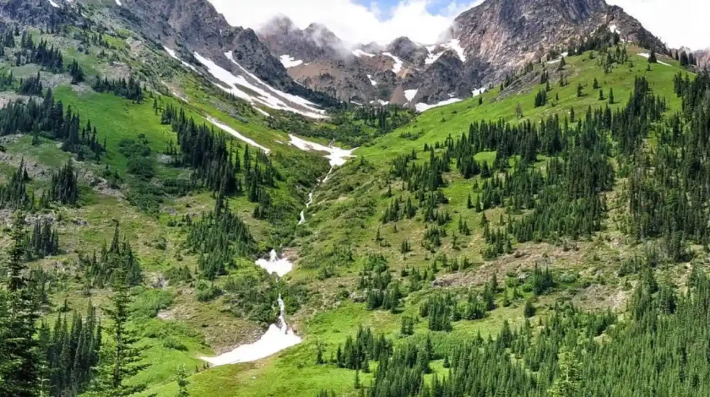
Subalpine forests and meadows
The subalpine zone, extending from 2,500 to 6,000 feet, marks a transition to harsher climatic conditions with shorter growing seasons. Trees in this zone, such as subalpine fir, mountain hemlock, and Alaska yellow-cedar, exhibit structural adaptations to heavy snow loads, including flexible branches and conical profiles. Near the upper limit of this zone, open meadows feature dense displays of wildflowers, including lupine, Indian paintbrush, and glacier lilies. Animals such as hoary marmots, American pikas, and sooty grouse rely on these open meadows for foraging during the summer months.
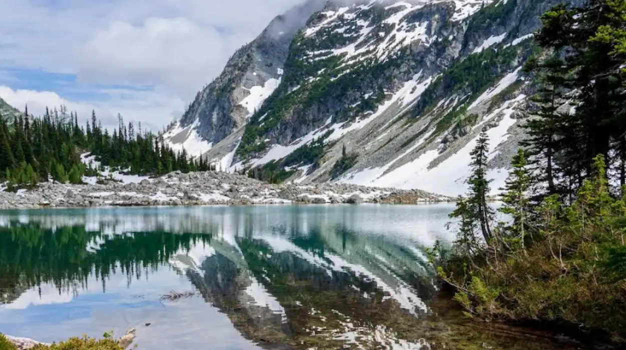
Alpine tundra and glaciers
Above the tree line, typically exceeding 6,000 feet, lies the alpine tundra zone, an environment shaped by extreme cold, high winds, and perpetual snow. Vegetation is limited to low-growing perennial herbs, mosses, and lichens that grow close to the rock surfaces to survive the freezing winds. This zone contains the park’s extensive glacier networks, permanent snowfields, and rugged cirques. Specialized wildlife species, including the American pipit, white-tailed ptarmigan, and mountain goat, possess physical adaptations that enable them to navigate and survive year-round in this exposed terrain.
What are the long-term impacts of climate change on these trails?
The long-term impacts of climate change on these trails include accelerated glacial retreat, increased frequency of destructive geomorphic events, and shifts in the geographic distribution of alpine ecosystems. These changes alter trail conditions and complicate wilderness management.
Glacial retreat and hydrologic shifts
Accelerated melting of the park’s 300-plus glaciers directly alters the hydrology of the surrounding trail networks. Glaciers act as natural reservoirs, regulating streamflow by releasing water slowly throughout the dry summer months. As glaciers shrink, summer streamflows decline, leading to seasonal water scarcity at high backcountry campsites. Conversely, early-season glacial runoff increases, causing higher, more turbulent stream crossings that can wash out trail bridges and erode low-lying path segments along glacier-fed rivers like the Skagit and Stehekin.
Geomorphic events and infrastructure damage
Rising global temperatures destabilize alpine slopes by thawing the mountain permafrost that binds loose rock faces together. This loss of structural integrity increases the frequency of rockfalls, debris flows, and landslides across high-elevation trails. Intense, short-duration storm events cause flash flooding, triggering massive washouts on unpaved access roads like Cascade River Road. The National Park Service faces escalating maintenance costs to repair damaged trail beds, clear fallen talus, and rebuild structural retaining walls along exposed ridges.
Ecosystem compression and trail experiences
As subalpine temperatures warm, the tree line migrates upward into areas previously occupied by alpine tundra. This process shifts the classic hiking experience by altering the open, panoramic vistas that define popular routes like Maple Pass and Sahale Arm. Delicate wildflower meadows face encroachment from woody shrubs and conifers, compressing the specialized habitat available to alpine fauna. Hikers will encounter changing landscapes where traditional snowfields vanish, alpine lakes dry up, and the distribution of native plant communities shifts northward and upward.
How should hikers prepare for the unique demands of the North Cascades?
Hikers should prepare for the unique demands of the North Cascades by carrying the ten essential survival items, practicing strict physical conditioning, and executing meticulous trip logistics. These steps mitigate the inherent risks of entering a remote, rugged alpine environment.
Navigational and emergency equipment
The remote nature of the North Cascades means that cellular service is non-existent across most of the park’s trail systems. Hikers must carry redundant navigation tools, including a topographic map, a magnetic compass, and a satellite communication device equipped with Global Positioning System tracking capabilities. The ten essential items must be present in every pack: navigation, a headlamp with extra batteries, sun protection, first aid supplies, a knife and repair kit, fire-starting tools, emergency shelter, extra food, extra water, and seasonal insulation clothing.
Physical conditioning for steep terrain
Trails in the North Cascades are renowned for their steepness, often skipping the long switchbacks common in other mountain ranges in favor of direct, vertical ascents. A typical day hike can require climbing 1,000 vertical feet per mile over rocky, root-filled terrain. Hikers must engage in pre-season physical conditioning that emphasizes cardiovascular endurance, leg strength, and core stability. Training should include weighted step-ups, hill intervals, and eccentric quad exercises to prepare muscles for the strenuous descents that strain knee joints and ankles.
Logistics, water treatment, and trip planning
Meticulous logistical planning is critical due to the park’s limited entry points and dispersed infrastructure. Hikers must verify trailhead road conditions via the National Park Service website prior to departure, as seasonal washouts can add miles to an itinerary. Water sources must be treated using a filter certified to remove protozoa and bacteria, as wilderness water sources can carry pathogens like Giardia lamblia. Finally, hikers must submit a detailed trip itinerary to a trusted emergency contact before entering the backcountry, ensuring that search and rescue personnel have precise search parameters if an emergency occurs.
What are the best hiking trails in North Cascades National Park?
Some of the best hiking trails in North Cascades National Park include Cascade Pass Trail, Maple Pass Loop, Blue Lake Trail, and Sahale Arm Trail. These hikes offer access to alpine scenery, glacier views, mountain lakes, wildflower meadows, and panoramic viewpoints.