Key Points
- Weather Shift: Seattle is transitioning from warm, summery temperatures on Tuesday to cooler, cloudier conditions on Wednesday.
- Onshore Flow: A shift to onshore winds is driving the drop in temperature, bringing daytime highs back down into the 60s and 70s Fahrenheit.
- Precipitation Risks: Showers are possible on Wednesday, with the highest probability concentrated along the Pacific Coast and throughout the Cascade Mountain range.
- Puget Sound Impact: Residents in the Puget Sound lowlands face a slight chance of light, scattered showers, though significant rainfall is not anticipated.
Seattle (Evening Washington News) June 3, 2026 – Following a brief stretch of unseasonably warm weather on Tuesday, an onshore wind flow has shifted across western Washington, triggering a notable drop in temperatures and introducing a blanket of cloud cover alongside a chance of mid-week showers. Forecasters note that while Tuesday offered summer-like warmth, Wednesday will see a return to more classic Pacific Northwest conditions, with daytime temperatures struggling out of the 60s and low 70s.
- Key Points
- What is Causing the Sudden Drop in Seattle’s Temperatures?
- Where is Rain Most Likely to Fall in Western Washington on Wednesday?
- How Will the Marine Layer Affect Daily Highs?
- Background of the Pacific Northwest Marine Push
- The Mechanics of an Onshore Push
- Historical Context for June Weather
- Prediction: How Will This Weather Shift Affect Commuters and Outdoor Workers?
- Consequences for Outdoor Industries and Energy Demand
The primary threat for measurable rainfall remains confined to the coast and the Cascade Mountains, leaving the urban core of the Puget Sound with a lower, more scattered chance of light precipitation.
What is Causing the Sudden Drop in Seattle’s Temperatures?
The primary mechanism behind the abrupt weather transition across western Washington is a shift toward a robust onshore flow.
Onshore flow occurs when cooler, moisture-laden air over the Pacific Ocean is pushed inland toward the lower pressure created by the previous day’s heating over land. This atmospheric shift acts as a natural air conditioner for the region, effectively capping the heat wave and reintroducing marine stratocumulus clouds across the lowlands.
Meteorological data indicates that after a peak in warmth on Tuesday, the marine layer pushed aggressively inland overnight.
This has resulted in a widespread cloud deck greeting commuters on Wednesday morning, preventing early solar radiation from warming the ground surface as efficiently as it did during the prior 24-hour cycle.
Where is Rain Most Likely to Fall in Western Washington on Wednesday?
While cloud cover is expected to be nearly universal across the region during the first half of the day, actual rainfall production will be highly dependent on topography.
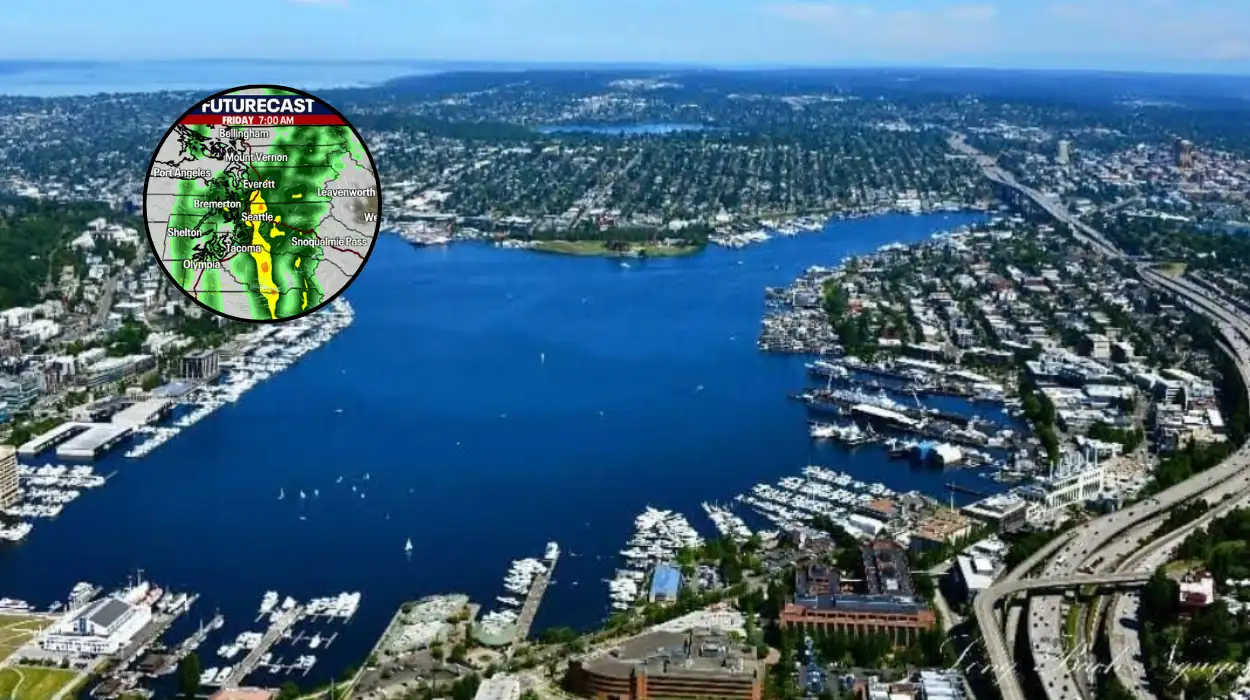
According to regional forecast tracking, the highest probability of persistent showers is concentrated in two specific geographic zones:
- The Pacific Coast: Areas such as Hoquiam, Ocean Shores, and the Olympic Peninsula are experiencing the direct brunt of the marine air mass, making them prone to steadier drizzle and light rain.
- The Cascade Range: As the moisture-laden onshore winds encounter the rising terrain of the Cascades, the air is forced upward—a process known as orographic lift. This cooling process condenses moisture rapidly, leading to a higher frequency of showers along the western slopes and mountain passes.
For the densely populated Puget Sound metropolitan area—stretching from Everett through Seattle to Tacoma—the threat of rain remains considerably lower.
Meteorologists describe the precipitation potential for the urban corridor as “light and nature-limited,” meaning any showers that do develop will likely be brief, localized, and insufficient to cause significant accumulation or travel disruptions.
How Will the Marine Layer Affect Daily Highs?
The presence of the marine layer means daytime high temperatures on Wednesday will experience a sharp correction compared to Tuesday’s peak. Instead of the mid-to-upper 80s observed in some inland areas earlier in the week, Wednesday’s highs are projected to max out in the mid-60s to low 70s. This brings the region back into alignment with historical seasonal averages for early June.
Background of the Pacific Northwest Marine Push
The sudden cooling trend observed in Seattle is a classic example of a regional meteorological phenomenon known locally as a “marine push” or “onshore push.” In western Washington, these events typically occur during the late spring and summer months following a period of high pressure and warm interior temperatures.
The Mechanics of an Onshore Push
When a ridge of high pressure sits over the Pacific Northwest, it clears the skies and allows continental air to warm up the interior valleys of Washington and Oregon. As this interior landmass heats up, the air expands and rises, creating a localized area of thermal low pressure.
Meanwhile, out over the Pacific Ocean, the air remains significantly cooler and denser. The substantial temperature and pressure differential between the hot interior land and the cold ocean creates a strong pressure gradient.
Once the high-pressure ridge begins to weaken or slide eastward, this gradient forces the dense, cool marine air to rush inland through low-level gaps in the coastal topography, such as the Strait of Juan de Fuca and the Chehalis River Valley.
Historical Context for June Weather
June in Seattle is historically characterized by this exact atmospheric tug-of-war. Locally referred to by residents as “Junuary” or “June Gloom,” the month frequently alternates between premature summer warmth and prolonged stretches of cool, overcast marine weather. Statistically, stable summer weather does not firmly establish itself in the Puget Sound region until after the first week of July.
Therefore, the transition from Tuesday’s warmth to Wednesday’s cloud cover represents a standard cyclical pattern for western Washington’s late-spring climate.
Prediction: How Will This Weather Shift Affect Commuters and Outdoor Workers?
The transition to cooler temperatures and cloud cover is expected to have a direct, measurable impact on various segments of the local population, particularly commuters, outdoor laborers, and regional utility managers.
For the morning and evening commutes along the Interstate 5 and Interstate 405 corridors, the primary variable will be visibility and minor road dampness rather than severe weather hazards. The influx of the marine layer can create pockets of low-level mist and fog, particularly near water bodies and river valleys.
While heavy hydroplaning risks are low due to the light nature of the forecast showers, the initial dampening of roads after a dry, warm spell can mix with accumulated automotive oils, creating slick driving conditions during the initial hours of precipitation.
Consequences for Outdoor Industries and Energy Demand
Outdoor workers, including construction crews, agricultural laborers, and landscaping personnel, will experience a significant reduction in heat-related fatigue. The drop from near-80-degree weather to the 60s eliminates the risk of heat stress, allowing for safer and more productive operating conditions across regional jobsites.
Conversely, regional energy grid operators will see an immediate shift in consumer consumption patterns.
Tuesday’s warmth typically drives a spike in electricity usage as residential and commercial air conditioning units are activated across the metro area. The return of the 60s and 70s on Wednesday will naturally mitigate this cooling demand, flattening the afternoon energy consumption curve and reducing strain on local electrical infrastructure.