Key Points
- Immediate Warming Trend: Sunshine and warmer conditions are returning to Western Washington on Thursday, June 18, 2026, pushing daytime temperatures into the upper 70s to low 80s.
- Peak Match Day Conditions: Friday is forecasted to be even warmer, with widespread highs in the 80s providing ideal stadium and fan zone conditions for the highly anticipated USA vs Australia FIFA World Cup match in Seattle.
- Brief Interruption Before Extreme Heat: A minor, temporary cooldown will sweep through the region on Saturday, acting as a brief reprieve before a major thermal ridge builds early next week, threatening the hottest temperatures of the season so far.
Seattle (Evening Washington News) June 18, 2026 A significant meteorological shift is underway across Western Washington as a robust high-pressure system ushers in a prolonged period of clear skies and steadily climbing temperatures. According to data monitored on June 18, 2026, regional weather patterns indicate that after a period of cooler June conditions, the Pacific Northwest is entering a multi-day warming cycle.
- Key Points
- Will the Warm Weather Last Through the USA-Australia World Cup Match?
- What is the Precise Day-by-Day Temperature Trajectory for Western Washington?
- Friday’s Heat Spike
- Saturday’s Brief Cool Down
- Why is a Severe Heat Wave Predicted for Early Next Week?
- Background of the Summer Weather Patterns in Western Washington
- Prediction: How the Extreme Heat Shift Will Affect Residents and Infrastructure
- Transportation and Municipal Operations
- Regional Energy Demands
Forecasters confirm that temperatures on Thursday will ascend into the upper 70s to low 80s, accompanied by widespread sunshine. The incoming atmospheric pattern is expected to intensify by Friday, pushing regional thermometer readings deep into the 80s just as the city prepares to host a massive international sporting fixture, before a temporary weekend drop sets the stage for an intense heatwave early next week.
Will the Warm Weather Last Through the USA-Australia World Cup Match?
As reported by senior meteorologists tracking regional data on June 18, 2026, the arrival of this clear atmospheric profile aligns precisely with massive regional events.
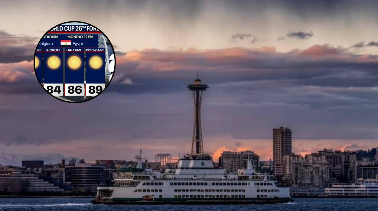
The primary focus for local authorities and incoming visitors is Friday, June 19, 2026, which is slated to bring the warmest weather of the week so far.
Atmospheric profiling shows that temperatures on Friday will comfortably settle well into the 80s across the Interstate 5 corridor and the broader Puget Sound basin.
Experts state that this will create optimal, clear-sky environments for the thousands of international spectators arriving for the FIFA World Cup Group D fixture between the United States and Australia at Seattle Stadium (Lumen Field).
With a 0% chance of rain forecasted during the peak daylight hours, both sports analysts and stadium operations teams have expressed optimism regarding field conditions and general fan comfort outside the venue.
What is the Precise Day-by-Day Temperature Trajectory for Western Washington?
Analysis of the immediate coastal and inland trends reveals a distinct three-phase weather pattern over the next few days.
The initial phase begins on Thursday, June 18, 2026, acting as a clear transitional bridge out of the weaker marine layers that dominated earlier in the week. Daylight conditions are characterized by a 13°C morning baseline warming rapidly into a daytime high of 24°C (approximately 75°F to 80°F depending on local microclimates). Winds are holding steady from the north at 10 mph, keeping the humidity levels at a comfortable 59% during peak hours.
The UV index is recorded at a high level of 8, prompting public health advisories regarding sun exposure. By Thursday night, conditions will shift slightly to partly cloudy with a low of 14°C and a nominal 10% chance of light, isolated precipitation.
Friday’s Heat Spike
The second phase features a more pronounced thermal squeeze on Friday, June 19, 2026. As the offshore flow strengthens, marine air will be entirely blocked from entering the basin.
This will drive interior valleys and urban concrete environments toward peak afternoon highs reaching the mid-to-upper 80s.
Saturday’s Brief Cool Down
The final phase of the immediate cycle introduces a temporary disruption on Saturday, June 20, 2026.
A weak marine push from the Pacific Ocean will temporarily lower highs back down by several degrees, re-introducing fractured morning clouds and providing an atmospheric buffer.
Why is a Severe Heat Wave Predicted for Early Next Week?
While the short-term forecast highlights excellent recreational and sporting conditions, long-range atmospheric modeling reveals a more intense development developing immediately after the weekend. Meteorologists warn that the Saturday cooldown will be short-lived.
By Sunday, June 21, 2026, an expansive and remarkably strong upper-level ridge of high pressure—often colloquially termed a “heat dome”—is scheduled to position itself directly over the Pacific Northwest.
This system will trap descending air, compressing it and warming it substantially at the surface. Current projection models indicate that early next week will bring the most intense heat of the summer season to date, with interior areas potentially threatening record-breaking territories.
Background of the Summer Weather Patterns in Western Washington
The dramatic swing from mild, moisture-laden marine air to intense interior heat is a classic hallmark of the late spring and early summer transition in the Pacific Northwest.
Historically, June in Seattle features alternating patterns, often referred to by locals as “June Gloom,” where persistent low-pressure troughs sit off the coast and drag cool, damp air inland.
However, when strong sub-tropical high-pressure ridges build northward from California or eastward from the desert southwest, they effectively shut down the oceanic conveyor belt.
This boundary interaction creates a stark contrast: within 24 to 48 hours, the region can shift from overcast skies in the 60s to intense, direct sunlight exceeding 80 degrees.
The suddenness of these transitions regularly presents operational challenges to regional infrastructure that is historically adapted to more temperate, cooler regimes.
Prediction: How the Extreme Heat Shift Will Affect Residents and Infrastructure
The sudden escalation in regional temperatures across Western Washington will have immediate, cascading effects on several specific segments of the population and municipal systems.
Because a significant percentage of residential properties in the Seattle metropolitan area lack centralized air conditioning systems, an abrupt spike into the 80s—and potentially higher next week—poses an immediate risk of heat exhaustion and heatstroke.
Vulnerable populations, particularly the elderly, unhoused individuals, and those with pre-existing cardiovascular conditions, will face heightened physiological stress. Emergency medical services are expected to see an increase in heat-related dispatches.
Transportation and Municipal Operations
The influx of tens of thousands of global sports fans for the USA-Australia World Cup match on Friday will severely test transit networks under high thermal loads. Commuter rail lines, light rail systems, and standard asphalt roadways absorb and retain heat rapidly.
High ambient temperatures can expand light rail tracks, forcing transit agencies to implement precautionary speed restrictions to prevent warping. Additionally, the high UV index of 8 requires local event organizers to establish dedicated hydration stations to mitigate mass dehydration incidents in open-air fan zones.
Regional Energy Demands
Seattle’s electrical grid will experience a sharp, distinct surge in consumption beginning Thursday afternoon and peaking early next week.
As residential window units and commercial HVAC systems run continuously to combat the building heat, regional utility providers will have to reallocate power reserves to prevent localized transformer overloads.