Key Points
- Morning Transition: Early morning cloud cover across Western Washington is systematically burning off to reveal widespread sunshine by Wednesday afternoon.
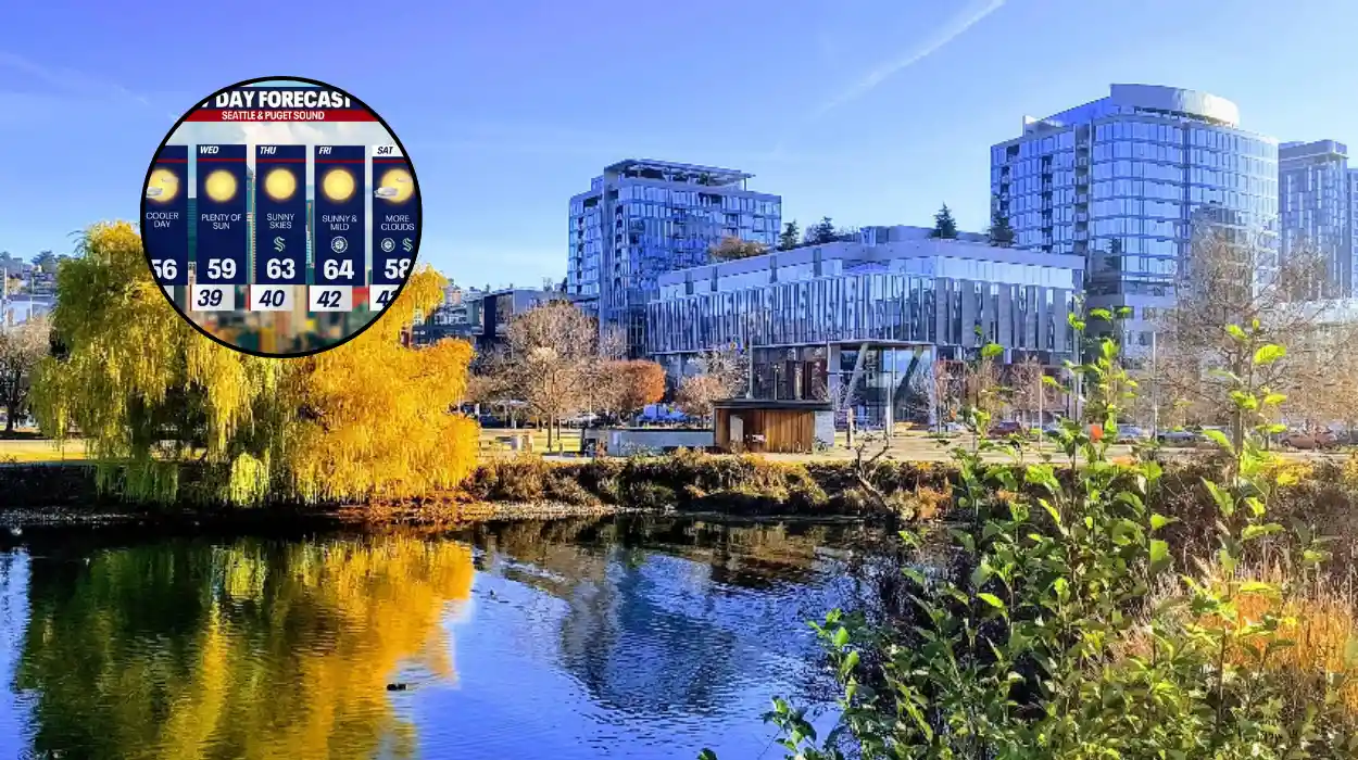
- Temperature Rebound: Maximum afternoon temperatures are projected to climb into the mid to upper 70s Fahrenheit across the Puget Sound region.
- Wind Mitigation: Regional wind speeds are noticeably calmer following a highly gusty Tuesday, though localized breezy conditions persist through the Cascade gaps and Central Washington.
- Extended Heat Outlook: A sustained warming trend will continue throughout the week, with temperatures tracking to return to the 80s by Friday afternoon.
- Summer Solstice Setup: Above-average seasonal temperatures are expected to extend well into next week as a dominant high-pressure system maintains atmospheric control ahead of the official start of summer on Sunday.
Seattle (Evening Washington News) June 17, 2026 — An persistent marine push of morning clouds is scheduled to burn off across the metropolitan area, clearing the path for substantial afternoon sunshine and temperatures climbing safely into the 70s. According to meteorological reporting compiled by the FOX 13 Seattle weather tracking team, a progressive atmospheric shift is unfolding across Western Washington on Wednesday, offering a seasonal transition toward typical summer conditions. While residents across the Puget Sound woke up to heavily overcast skies, satellite monitoring indicates that daytime solar heating is rapidly eroding the low-level cloud deck from the inside out, establishing a clear sky pattern for the remainder of the day.
- Key Points
- How Long Will the Current Onshore Warming Trend Persist in the Puget Sound?
- When Will the Regional Wind Speeds Taper Off?
- What Does the Extended Forecast Reveal About the Official Arrival of Summer?
- Background of the Particular Development
- Prediction: How This Development Can Affect the Local Population
As detailed in regional meteorological assessments, the maximum daytime temperatures are heavily favoured to settle into the mid to upper 70s across the immediate Seattle corridor and the greater lowlands.
The shift marks a distinct departure from the volatile and wind-swept conditions experienced over the preceding 24 hours.
The FOX 13 weather team noted that the regional wind profiles will be significantly calmer on Wednesday compared to a notably gusty Tuesday sequence. However, full atmospheric stillness is not anticipated, as localized breezy conditions are still actively moving through the Cascade gaps and pushing eastwards into the valleys of Central Washington.
How Long Will the Current Onshore Warming Trend Persist in the Puget Sound?
The primary driver behind the evolving meteorological pattern is a robust upper-level ridge of high pressure that is beginning to strengthen and assert dominance over the Pacific Northwest geography.
Analysts from the FOX 13 weather station state that this specific high-pressure mechanism is functioning as an atmospheric block, effectively redirecting cooler, moisture-laden marine systems away from the coastline and trapping warmer air columns over the landmass. As a result, the immediate post-cloud environments will benefit from intense solar radiation throughout the afternoon hours.
The data indicates that this structural warming trend is not a brief or isolated event. The meteorological team outlines a clear trajectory where the daily maximums will steadily escalate over the next 48 hours.
By Friday, the lowlands of Western Washington are predicted to shed the 70-degree range entirely, with thermometer readouts returning to the low-to-mid 80s across the interior sectors.
When Will the Regional Wind Speeds Taper Off?
The severe gusts that defined the region’s Tuesday weather have largely exhausted their energy, transitioning into a light onshore flow. Localized wind monitors confirm that while the urban centers of Seattle, Tacoma, and Bellevue will enjoy highly stable and calm conditions, the geographical topography of the state ensures that mountain passes and gap environments remain structurally dynamic.
Air pressure differentials between the marine west side and the arid east side of the Cascade Crest are continuing to draw air current streams through narrow passages.
This process keeps a steady, predictable breeze active across eastern King, Pierce, and Snohomish counties, which serves to moderate the afternoon heat for communities nestled directly against the foothills.
What Does the Extended Forecast Reveal About the Official Arrival of Summer?
The extended outlook underscores a powerful atmospheric acceleration as the region approaches the weekend timeline.
According to the long-range modeling verified by regional forecasters, above-average temperatures are firmly locked into the system, driven by the sustained presence of the high-pressure dome. The warming trend is precisely aligned with the astronomical calendar, as the summer solstice is officially scheduled to occur on Sunday, June 21.
Meteorologists tracking the system indicate that the solstice will initiate an extended stretch of high summer weather, with temperature readings expected to remain consistently above the historical seasonal baseline of 71 degrees Fahrenheit.
Rather than experiencing the traditional late-June dip, Western Washington is poised to see an expansion of the thermal ridge, which will push ambient temperatures well above typical averages into the early days of the following week.
Background of the Particular Development
The current shift from unstable, breezy marine weather to a settled, high-pressure system reflects the classic structural onset of the Pacific Northwest summer macro-climate.
Historically, the month of June in Western Washington—frequently referred to by locals as “June Gloom”—is characterized by a stubborn marine layer that acts as a natural air conditioner, compressing temperatures and generating persistent overcast conditions that struggle to clear before mid-afternoon.
The transition observed on Wednesday, June 17, 2026, marks the definitive breakdown of that cool marine regime for the season.
The preceding gusty Tuesday was the product of a compressed thermal trough moving inland, which effectively cleared out the stagnant moisture and paved the way for the current ridge expansion. This setup is a prerequisite for the regional atmosphere to transition from spring volatility to the sustained, dry heat patterns that typically dominate the months of July and August.
Prediction: How This Development Can Affect the Local Population
The steady progression from the mid-70s on Wednesday to the 80s by Friday, culminating in an unseasonably warm start to official summer, will have immediate, tangible impacts on the general population of Western Washington.
- Pollen and Allergen Escalation: The sudden influx of unbroken sunshine and climbing temperatures will trigger an immediate spike in regional pollen counts. Tree pollen levels, which traditionally dominate the atmosphere through the end of June, will rapidly intensify under dry conditions. This will directly impact allergy sufferers and individuals with respiratory sensitivities across the Puget Sound, requiring increased reliance on indoor air filtration and preventative medical treatments.
- Elevated Outdoor Recreation and Heat Exposure: With the arrival of the longest days of the year coinciding with highs in the 80s, local parks, trails, and waterways will experience a massive surge in public utilization. Because the local population is structurally unaccustomed to sudden heat spikes early in the season, public health agencies will likely see an uptick in heat-related fatigue cases.
- Water Safety Hazards: While ambient air temperatures are rising into the upper 70s and 80s, regional water bodies—including Lake Washington, the Puget Sound, and feeding rivers—remain dangerously cold due to recent snowpack melt. This stark differential creates a high risk of cold-water shock for swimmers and recreational boaters who may misjudge water safety based on the warm afternoon sun.