Key Points
- Immediate Forecast: Washington, D.C., is experiencing a dry, sunny, and highly comfortable Tuesday with significantly low humidity.
- Temperature Metrics: High temperatures for Tuesday are projected to settle near 81 degrees, following early morning lows that dipped into the 50s and low 60s.
- Atmospheric Controls: High pressure overhead combined with regional winds remains the driving force behind keeping the air mass dry and pleasant.
- Midweek Transition: A shift towards a warmer and more humid meteorological pattern is expected on Wednesday, with highs rising back into the upper 80s and low 90s.
- Precipitation Risks: Light, passing showers are possible on Wednesday, transitioning into a heightened risk of strong afternoon and evening thunderstorms by Thursday.
- Holiday and Weekend Outlook: Skies are forecast to clear by Friday morning, paving the way for a pleasant Juneteenth holiday and a comfortable, sunny weekend for Father’s Day.
Washington (Evening Washington News) June 16, 2026 – FOX 5 Weather News reported on June 16, 2026, that an atmospheric shift is unfolding across the District of Columbia metropolitan area, bringing a briefly cool and comfortable Tuesday before a significant escalation in humidity and temperature takes hold midweek. Residents across the capital region experienced a refreshing start to the day as early morning temperatures dipped deep into the 50s and lower 60s, a notable departure from typical mid-June moisture levels.
According to detailed meteorological updates, a dominant system of high pressure situated directly over the region, paired with steady surface winds, is actively acting as a barrier against tropical moisture, keeping regional conditions dry and humidity tightly controlled through the afternoon.
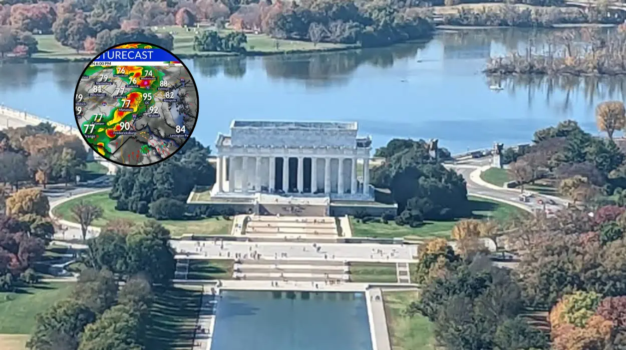
As documented by the reporting team at FOX 5, Tuesday’s daytime high temperature is tracking slightly below the seasonal average, with peak afternoon warmth expected to top out at approximately 81 degrees Fahrenheit.
This period of pleasant weather is serving as a brief atmospheric cushion before a more volatile summer air mass moves into the Mid-Atlantic. Meteorologists have confirmed that the local weather profile will shift dynamically within the next 24 hours, introducing a standard high-heat and high-moisture pattern that will drive the heat index upward across the District, Maryland, and Northern Virginia.
Will the Low Humidity in Washington Last Past Tuesday?
The exceptionally dry air currently settling over the National Mall and surrounding jurisdictions is entirely temporary.
According to the data published by FOX 5, the high-pressure system providing the current meteorological relief will begin migrating eastward by late Tuesday evening.
This movement will alter the regional wind direction, drawing up a highly saturated maritime air mass from the south.
By Wednesday morning, the cool morning breezes will be entirely replaced by a thick layer of humidity.
The immediate impact of this moisture return will be felt in daytime highs, which are projected to spike rapidly back into the upper 80s and lower 90s.
While Tuesday offers ideal conditions for outdoor activities, Wednesday will require adjustments for individuals sensitive to sudden changes in air quality and humidity.
What Is the Chance of Rain and Thunderstorms Later This Week?
As moisture levels surge on Wednesday, the regional atmosphere will become increasingly unstable, opening the door for precipitation. The latest regional forecast states that a few passing showers are possible during the middle of the week.
However, meteorologists emphasize that Wednesday is explicitly not expected to be a total washout, with showers remaining highly scattered and brief.
The primary meteorological concern shifts heavily to Thursday. As extreme heat and moisture build simultaneously over the urban heat island of Washington, a far more robust weather front is scheduled to arrive. Experts note that a significantly better chance of afternoon and evening thunderstorms will develop on Thursday.
Because of the sheer volume of heat energy and moisture acting as fuel, some of these developing storms could easily become severe, carrying the potential for localized damaging winds, heavy downpours, and frequent lightning.
What Kind of Weather Is Forecast for Juneteenth and Father’s Day Weekend?
For residents planning public observations or private family gatherings, the long-term forecast offers highly reassuring data.
The unstable air mass responsible for Thursday’s thunderstorm threat is projected to clear the coast relatively quickly. Morning showers may linger into the early hours of Friday, but these will steadily move out as a secondary push of dry air filters into the region.
Consequently, temperatures will ease slightly by Friday afternoon, setting up an ideal environmental backdrop for the federal Juneteenth holiday.
The upcoming weekend, which uniquely aligns with both Father’s Day celebrations and the official astronomical first day of summer, is currently locked into a highly favorable pattern.
The forecast mandates a return to completely sunny, stable, and comfortable conditions through Saturday and Sunday, offering a clean break from tropical humidity before the cyclical return of storm chances and heavy moisture early next week.
Background of the Meteorological Shift
This rapid oscillation between dry continental air and humid tropical air is a hallmark of the transition into mid-summer across the Mid-Atlantic states.
During the month of June, the jet stream routinely migrates northward toward the Canadian border, weakening its ability to push sustained cool fronts through the southern and eastern United States.
When a temporary high-pressure system breaks off and settles over the Appalachian chain, it brings brief periods of low humidity and lower-than-average temperatures, precisely like the conditions observed this Tuesday.
However, without a permanent polar air mass to back it up, these systems are quickly overridden by the Bermuda High—a semi-permanent high-pressure system anchored over the Atlantic Ocean.
The clockwise rotation of the Bermuda High acts as a massive atmospheric pump, continuously drawing warm, unstable, moisture-laden air from the Gulf of Mexico and the Caribbean up the eastern seaboard.
This process directly explains the rapid transformation from Tuesday’s comfortable 81-degree reading to Thursday’s anticipated severe thunderstorm threat, as the local environment becomes a battleground between lingering dry air and surging tropical moisture.
Prediction and Audience Impact
This multi-day weather transition will directly impact commuters, outdoor workers, event organizers, and regional energy managers across the Washington, D.C. area.
For the general public and commuters, the sudden spike in humidity and temperature on Wednesday and Thursday will significantly increase regional cooling demands, driving up electricity usage across the local grid. Outdoor workers and contractors must prepare for a sharp increase in heat-related fatigue on Wednesday as temperatures cross back into the 90-degree threshold under oppressive humidity levels.
Furthermore, the Thursday evening thunderstorm forecast presents a distinct operational risk for transit networks and flight schedules out of Ronald Reagan Washington National Airport and Washington Dulles International Airport.
Commuters should anticipate potential delays during the Thursday evening rush hour due to reduced visibility and localized flash flooding typical of mid-summer convective storms.
Conversely, the swift clearance of the front ahead of Juneteenth and Father’s Day weekend will provide a highly lucrative boost to the local hospitality, tourism, and outdoor recreation sectors, ensuring maximum capacity for events along the Southwest Waterfront and across the National Mall.