Key Points
- Washington, D.C. will experience mostly sunny skies on Tuesday with high temperatures near 76 degrees Fahrenheit.
- Overnight low temperatures dipped into the 50s, creating a cool start to the day before warming through the morning.
- Light layers may be needed early Tuesday before conditions warm up.
- A few showers developed over the mountains but are not expected to affect the D.C. area.
- FOX 5’s Taylor Grenda reports the region will remain dry through the end of the week and possibly into the start of the weekend.
- Tuesday’s temperatures are slightly below average with low humidity, making for a refreshing day.
- Wednesday will stay dry with low humidity but bring a warmer feel, with highs climbing into the mid-80s.
- By Thursday and Friday, summer conditions return with highs potentially reaching the 90s and humidity building.
- Hotter, more humid conditions will bring a chance for showers and storms by Sunday and Monday afternoons.
Washington (Evening Washington News) June 2, 2026 – A mostly sunny and comfortable Tuesday is ahead for the Washington, D.C. region, with high temperatures near 76 degrees, according to the latest weather forecast. Overnight lows dipped into the 50s, bringing a cool start before temperatures rise through the morning, meaning light layers may be needed early Tuesday before conditions warm. A few showers have developed over the mountains, but they are not expected to affect the D.C. area, FOX 5’s Taylor Grenda says the region will remain dry through the end of the week and possibly into the start of the weekend.
- Key Points
- What Makes Tuesday’s Weather Refreshing for Residents?
- When Will Warmer Temperatures Return to the Region?
- What Summer Conditions Are Expected by Thursday and Friday?
- When Will Rain and Storms Return to the Washington Area?
- How Long Will the Dry Period Last?
- What Should Residents Know About Temperature Trends?
- What Temperature Range Should People Expect Through the Weekend?
- What Clothing Recommendations Apply for Tuesday?
- What Outdoor Planning Considerations Apply for the Weekend?
- Background: Understanding Washington, D.C.’s Spring-to-Summer Weather Transition
- Prediction: How This Weather Development Can Affect Washington, D.C. Residents and Visitors
- Effects on Outdoor Event Planners and Attendees
- Health Considerations for Vulnerable Populations
- Economic Impact on Local Businesses
What Makes Tuesday’s Weather Refreshing for Residents?
Tuesday’s temperatures are expected to be slightly below average, and the low humidity will make for a refreshing day, as reported by Taylor Grenda of FOX 5. The combination of mostly sunny skies and comfortable temperatures creates ideal conditions for outdoor activities across the Washington metropolitan area.
When Will Warmer Temperatures Return to the Region?
Wednesday will stay dry with low humidity but bring a warmer feel, with highs climbing into the mid-80s, according to the forecast. This marks the beginning of a warming trend that will continue through the end of the work week.
What Summer Conditions Are Expected by Thursday and Friday?
By Thursday and Friday, summer conditions return, with highs potentially reaching the 90s and humidity building into the weekend, FOX 5 reported. The increase in humidity will make temperatures feel warmer than the actual thermometer readings, characteristic of typical summer weather in the Mid-Atlantic region.
When Will Rain and Storms Return to the Washington Area?
The hotter, more humid conditions will bring a chance for showers and storms by Sunday and Monday afternoons, Taylor Grenda of FOX 5 stated. While the week remains dry, weekend plans may need to account for potential afternoon thunderstorms as humidity peaks.
How Long Will the Dry Period Last?
FOX 5’s Taylor Grenda says the region will remain dry through the end of the week and possibly into the start of the weekend. This extended dry period provides several consecutive days of favourable weather conditions for residents and visitors alike.
What Should Residents Know About Temperature Trends?
Tuesday’s temperatures are expected to be slightly below average for this time of year, providing a brief respite before the heat arrives. This below-average temperature, combined with low humidity, creates particularly comfortable conditions.
What Temperature Range Should People Expect Through the Weekend?
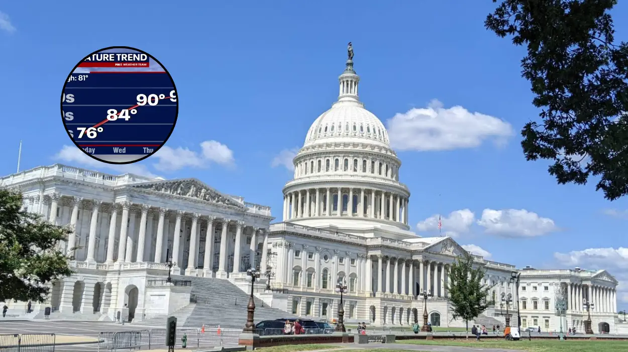
The temperature progression shows a clear warming pattern: 76 degrees on Tuesday, mid-80s on Wednesday, and potentially 90s by Thursday and Friday. This 15-degree increase over four days represents a significant shift toward typical summer conditions for the region.
What Clothing Recommendations Apply for Tuesday?
Light layers may be needed early Tuesday before conditions warm, as overnight lows in the 50s create a cool morning start. Residents should consider bringing a light jacket or sweater for morning commutes but will likely remove it as temperatures rise.
What Outdoor Planning Considerations Apply for the Weekend?
The chance for showers and storms by Sunday and Monday afternoons means outdoor event planners should have backup options ready, according to the forecast. Afternoon thunderstorms are common during hot, humid summer conditions in the D.C. area.
Background: Understanding Washington, D.C.’s Spring-to-Summer Weather Transition
The weather pattern described in this forecast represents a typical transition period for Washington, D.C. as the region moves from spring into summer temperatures. The Washington metropolitan area experiences significant temperature variability during late spring and early summer, with temperatures sometimes fluctuating by 15-20 degrees over just a few days.
The presence of showers over the mountains but not affecting the D.C. area demonstrates how local topography influences weather patterns in the region.
The Appalachian Mountains to the west often intercept weather systems before they reach the coastal plain where Washington, D.C. is located, creating distinct weather zones within relatively short distances.
Low humidity during the early part of the week is characteristic of air masses moving from the northwest, which typically bring drier, cooler air to the Mid-Atlantic region.
As the week progresses and temperatures rise, humidity builds as air masses shift from more southerly directions, bringing moist air from the Atlantic Ocean and Gulf of Mexico.
The forecast pattern of dry conditions mid-week followed by potential afternoon storms on the weekend is a classic summer weather pattern for Washington, D.C.
Afternoon and evening thunderstorms develop frequently during hot, humid periods when atmospheric instability increases, particularly when moisture and heat combine.
Taylor Grenda, the meteorologist cited in this forecast, reports for FOX 5, a major television station serving the Washington, D.C. media market. FOX 5 provides weather coverage for the entire Washington metropolitan area, including parts of Maryland, Virginia, and the District of Columbia.
Prediction: How This Weather Development Can Affect Washington, D.C. Residents and Visitors
The temperature progression from 76 degrees on Tuesday to potentially 90s by Friday will significantly affect daily commuters and outdoor workers in the Washington, D.C. region. Those who walk to transit stations or work outdoors will need to adjust their clothing and hydration strategies as the week progresses.
The cool morning starting temperatures in the 50s on Tuesday mean commuters should prepare for variable conditions within a single day.
Effects on Outdoor Event Planners and Attendees
The chance for showers and storms by Sunday and Monday afternoons directly impacts outdoor event planning for weekend activities.
Concert organizers, sports event coordinators, and festival planners must consider contingency plans for potential weather disruptions. The dry conditions through Thursday and Friday provide reliable windows for mid-week outdoor activities, but weekend events face greater uncertainty.
Health Considerations for Vulnerable Populations
The rapid temperature increase from mid-70s to 90s, combined with building humidity, presents health considerations for elderly residents, young children, and those with respiratory conditions. The shift from low humidity to higher humidity levels can affect individuals with asthma or other breathing difficulties. Air conditioning usage will likely increase significantly by Thursday and Friday as heat and humidity combine.
Economic Impact on Local Businesses
Retail businesses selling seasonal items will see shifting demand patterns as temperatures rise throughout the week. Restaurants with outdoor seating will experience higher patronage on Tuesday and Wednesday when conditions are most comfortable, while weekend outdoor dining faces weather-related uncertainty. The heating and cooling industry will see increased demand as residents adjust to changing temperatures.