Key Points
- Unseasonable Holiday Kickoff: The Memorial Day holiday weekend across the Washington, D.C., metropolitan region has commenced with unseasonably chilly temperatures, persistent gray skies, gusty winds, and periods of moderate to heavy rainfall.
- Soggy Saturday Dynamics: Meteorological reports indicate a Weather Impact Alert remains active through Saturday, with temperature highs struggling to exceed the upper 50s to low 60s Fahrenheit alongside persistent eastward winds.
- Gradual Sunday Improvement: Forecasters project drier periods and milder conditions for Sunday, with temperatures rebounding into the low to mid-70s, though residents must still navigate scattered showers and potential isolated thunder rumbles.
- Warmer Memorial Day Outlook: The federal holiday on Monday is expected to bring a more substantial transition toward summer-like conditions, featuring highs climbing into the upper 70s to lower 80s, despite a lingering possibility of late-afternoon precipitation.
- Coastal Maritime Hazards: The National Weather Service (NWS) has issued definitive alerts warning of rough surf and a high risk of dangerous, life-threatening rip currents along the mid-Atlantic coast throughout the extended holiday weekend.
Washington D.C. (Evening Washington News) May 23, 2026 Baltimore-Washington Weather Forecast Office, alongside regional broadcast meteorologists, confirmed on May 23, 2026, that an unseasonably cool, damp, and breezy weather system is significantly altering outdoor recreation and travel plans across the District of Columbia, Maryland, and Northern Virginia (DMV) at the start of the three-day Memorial Day holiday weekend. According to official meteorological data, the unofficial commencement of the summer season is being delayed by an stubborn atmospheric pattern bringing rounds of moderate to heavy rainfall, overcast skies, and localized threats of isolated thunderstorms.
- Key Points
- What Is the Detailed Meteorological Outlook for Saturday and Saturday Night?
- How Will Weather Conditions Evolve on Sunday and Memorial Day Monday?
- Detailed Sunday Adjustments
- Memorial Day Monday Projections
- What Maritime and Beach Hazards Face Holiday Travellers and Coastal Visitors?
- Background of the Disturbed Holiday Weather Pattern
- Prediction and Potential Effects on the Holiday Weekend Audience
- Consequences for Local Commerce and Tourism
- Public Health and Safety Vectors
While Saturday is projected to endure the heaviest and most widespread precipitation, meteorologists indicate that Sunday and Monday will experience a gradual, multi-staged improvement characterized by rising temperatures and increasingly dry intervals, though coastal areas remain under strict safety advisories due to rough surf and treacherous marine conditions.
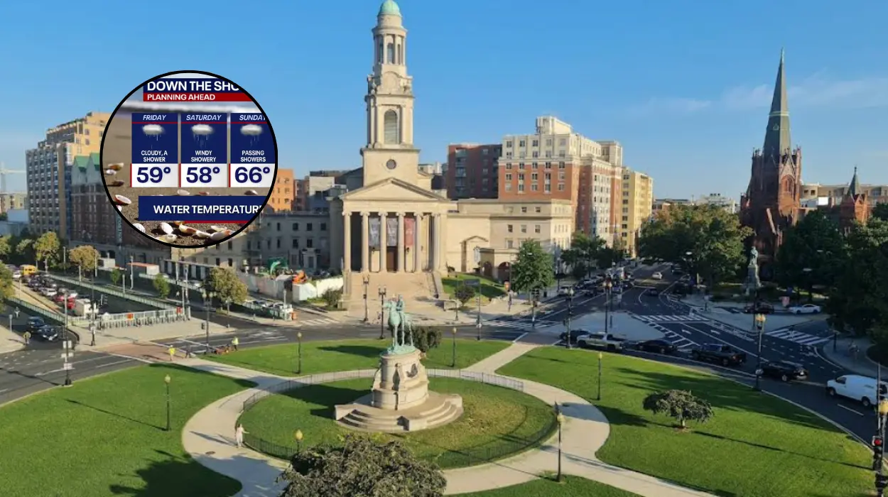
As reported by Chief Meteorologist Topper Shutt and meteorologists Kaitlyn McGrath, Miri Marshall, Grace Thornton, and Joe Speir of WUSA9, a Weather Impact Alert has been implemented through Saturday evening to account for the continuous rainfall and unseasonably suppressed thermal profiles. The weather team stated that residents will
“need an umbrella and a jacket all day Saturday”
as a consequence of a system delivering daytime highs ranging strictly between $58^\circ\text{F}$ and $63^\circ\text{F}$ ($14^\circ\text{C}$ to $17^\circ\text{C}$), driven by persistent easterly winds blowing at velocities of 10 to 20 miles per hour.
What Is the Detailed Meteorological Outlook for Saturday and Saturday Night?
The atmospheric conditions governing Saturday involve thick cloud cover, breezy conditions, and waves of organized precipitation moving through the urban corridor. According to data published by the National Weather Service, widespread rainfall accumulations across the broader eastern seaboard are projected to measure between 1.0 and more than 2.0 inches, stretching from the Gulf Coast up through southern New England, including the Potomac River basin.
An administrative update issued by the National Weather Service Baltimore/Washington division detailed that Saturday evening and overnight will see the continuation of these cloudy and cool parameters.
Overnight low temperatures are expected to settle into the low 50s Fahrenheit, with easterly to south-easterly winds maintaining a steady pace of approximately 10 miles per hour. While the core of the heavy, steady rain is expected to taper off into scattered showers after midnight, atmospheric moisture levels will remain high, leaving a baseline probability for an isolated thunderstorm or a rumble of thunder through the early hours of Sunday morning.
How Will Weather Conditions Evolve on Sunday and Memorial Day Monday?
The second half of the holiday weekend features a distinct, albeit gradual, meteorological transition. As broadcast in the regional weather analysis by the FOX 5 DC weather team, while the weekend represents the unofficial start to the summer season,
“there won’t be many good chances to break out the grill”
during the initial phases, though Sunday promises an incremental upgrade.
Detailed Sunday Adjustments
According to data compiled by WUSA9 meteorologists, Sunday will feature mostly cloudy skies but notably milder thermal readings. Daytime highs are forecast to rebound into a range between $70^\circ\text{F}$ and $75^\circ\text{F}$.
Winds are projected to shift to the southeast at 10 miles per hour. The meteorological consensus indicates that while Sunday will not be an absolute “washout,” residents will still likely have to dodge isolated or scattered late-afternoon and evening showers, with a low-level threat of an isolated thunderstorm.
Memorial Day Monday Projections
The federal holiday on Monday, May 25, is poised to offer the highest temperatures of the three-day weekend. The WUSA9 weather tracking system indicates that conditions will become mostly cloudy and substantially warmer, with high temperatures soaring into the upper 70s to lower 80s Fahrenheit ($25^\circ\text{F}$ to $28^\circ\text{C}$). Winds are expected to shift out of the north at roughly 10 miles per hour.
A minor risk of late-afternoon or evening showers remains embedded in the model data, but the daytime hours are expected to feature prolonged dry periods suitable for commemorative events.
What Maritime and Beach Hazards Face Holiday Travellers and Coastal Visitors?
The adverse weather conditions are not confined to inland precipitation; they extend significantly into the coastal waters of the mid-Atlantic and southeast beaches, impacting the hundreds of thousands of DMV residents who historically travel toward coastal resorts for the holiday weekend.
As reported by meteorologist Audrey Shirley of the Florida Public Radio Emergency Network (FPREN), definitive Rip Current Statements and Beach Hazards Statements have been verified and issued by the National Oceanic and Atmospheric Administration (NOAA) and the NWS along major portions of the East Coast. Shirley noted that
“rip currents formed from any wave height are dangerous, and any swimmer of any skill level is at risk of being swept into a current if they are not careful enough.”
According to NOAA wave height projections analysed on May 22, 2026, wave action along the Atlantic beaches is expected to verify between 1 and 5 feet throughout the weekend, with higher waves of 3 to 4 feet consolidating closer to shore by Sunday and Monday afternoon.
Oceanographic experts emphasize that higher wave heights directly correlate to stronger, more volatile rip currents, prompting lifeguards and beach patrols across the mid-Atlantic shoreline to urge extreme caution or total avoidance of the surf zone.
Background of the Disturbed Holiday Weather Pattern
The unseasonably cool and wet conditions impacting the Washington, D.C., region during the 2026 Memorial Day weekend are rooted in a complex atmospheric blocking pattern typical of late spring transitions in the eastern United States.
Historically, Memorial Day serves as the primary transition point where continental polar air masses fully retreat northward, allowing subtropical ridges to establish warm, humid air across the Mid-Atlantic.
However, meteorologists trace the current disruption to a slow-moving, low-pressure trough that became detached from the primary jet stream flow over the Ohio Valley. This system established a persistent “onshore flow”—a meteorological phenomenon where winds blow continuously from the cooler Atlantic Ocean onto the warmer landmass.
This easterly wind profile acts as an atmospheric conveyor belt, constantly feeding maritime moisture into the DMV region while pinning a dense layer of low-level stratus clouds against the Appalachian Mountains.
This specific configuration, colloquially known as a “backdoor cold front” or a damming event, effectively caps regional temperatures well below the climatological normal of $78^\circ\text{F}$ ($25.5^\circ\text{C}$) for late May, replacing typical early-summer sunshine with late-spring dampness.
Prediction and Potential Effects on the Holiday Weekend Audience
The prevailing weather anomaly is predicted to exert immediate structural and financial impacts across multiple segments of the regional audience, altering consumer behavior, transportation safety, and public health metrics through the conclusion of the holiday period.
For the millions of motorists utilizing major regional arteries such as the I-95, I-66, and I-495 corridors, the combination of intermittent heavy downpours, reduced visibility, and wet pavement is predicted to escalate vehicular accident rates and extend travel delays. Transportation analysts suggest that the wet weather will compress the traditional holiday return traffic into a narrower window on Monday evening as travelers truncate their outdoor weekend itineraries.
Consequences for Local Commerce and Tourism
The hospitality and outdoor recreation sectors throughout the DMV are projected to experience a quantifiable reduction in projected seasonal revenue. Local businesses relying on high-volume foot traffic—such as golf courses, outdoor visual arts festivals, community pools, and rooftop dining venues—will see lower engagement during Saturday’s rain. Conversely, indoor entertainment venues, museum complexes along the National Mall, and regional shopping centers are predicted to see a corresponding surge in patronage as residents seek alternative, climate-controlled environments.
Public Health and Safety Vectors
Public safety officials predict an elevated operational demand for emergency services, particularly along coastal resort zones where the NWS high-risk rip current advisories remain active. Despite cooler air temperatures, the presence of holiday crowds introduces a risk of surf-zone rescues if swimmers bypass lifeguard warnings. Inland, the rapid transition from a damp, $60^\circ\text{F}$ Saturday to a humid, $80^\circ\text{F}$ Monday is expected to cause sudden shifts in relative humidity, potentially impacting sensitive populations with respiratory vulnerabilities.