Mount Rainier National Park in Washington is a glaciated volcanic landscape, a major hiking destination, and a classic Pacific Northwest road-trip park. This guide covers the park’s best trails and views, plus the history, access patterns, and seasonal details that matter for planning.
- What is Mount Rainier National Park?
- Why does Mount Rainier matter?
- When should you visit?
- Which areas give the best views?
- Which trails are best for first-time visitors?
- Which hikes show the best mountain scenery?
- What trails are best for families?
- What should you know about access and closures?
- How should you plan a safe hike?
- Why does Mount Rainier stay relevant?
What is Mount Rainier National Park?
Mount Rainier National Park is a protected Washington park centred on Mount Rainier, a glacier-capped volcano with old-growth forests, subalpine meadows, lakes, waterfalls, and more than 260 miles of maintained trails. It was created by Congress on March 2, 1899, and remains one of the state’s most important outdoor destinations.
The park’s defining feature is Mount Rainier itself, a 14,411-foot peak in Pierce County that dominates the skyline across western Washington. The National Park Service describes the landscape as a mix of peaceful river-valley forest, high meadows, lakes, streams, wildflower fields, and glacier views. That variety is why the park works for many visitors, from short scenic walks to long backcountry routes.
The park also has strong ecological importance. The NPS says hikers encounter old-growth forest, subalpine meadows, and fragile wildflower zones that require staying on designated trails in heavily used areas such as Paradise, Sunrise, and Tipsoo Lake. These rules protect the landscape and preserve the visitor experience.
Why does Mount Rainier matter?
Mount Rainier matters because it combines a high-elevation volcano, large glaciers, old forest, and accessible alpine scenery in one park. That combination creates some of the most recognizable mountain views in Washington and supports year-round recreation, education, and conservation.
Historically, the park was the fifth national park designated by Congress. That status places it among the earliest protected landscapes in the United States and reflects its long-recognized national significance. The mountain itself also shapes local identity, tourism, and outdoor culture across western Washington.
Visitation confirms that importance. The park recorded 1,518,491 recreation visitors in 2018, and official historical visitation records show more than a million annual visitors in many recent years. That sustained demand means the park is both iconic and heavily used, so planning matters.
When should you visit?
The best time to visit Mount Rainier National Park for the widest trail access is July through September, when roads, hiking routes, and glacier viewpoints are most open. Summer and early autumn deliver the best mix of snow-free trails, clear views, and accessible high-country scenery.
Summer is the most reliable season for hiking because the park’s higher elevations stay buried under snow through much of the year. The National Park Service notes that snow plowing, maintenance work, and winter conditions limit access on park roads, and all vehicles must carry chains during the winter season from November 1 to May 1. That seasonal reality affects route choice, trail access, and travel time.
Autumn also works well for many visitors. Intrepid Travel’s visitor guidance identifies autumn as a strong season for colourful foliage, while summer remains the best period for broad access to trails and glacier spotting. For a first visit focused on views and hiking, late July through September is the safest planning window.
Which areas give the best views?
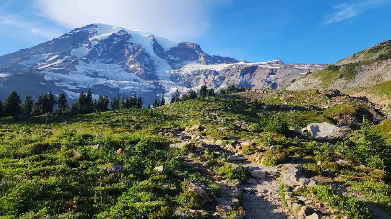
The best views come from Paradise, Sunrise, Longmire, and Mowich Lake. Paradise delivers iconic close-up mountain scenery, Sunrise gives expansive eastern views, Longmire offers forested ridge outlooks, and Mowich Lake provides quieter high-country access with strong summit views.
Paradise is the classic viewpoint area. The NPS highlights Nisqually Glacier views, subalpine meadows, and the Skyline Trail to Myrtle Falls, all from the park’s most famous visitor zone. This area works well for travellers who want a concentrated set of scenic stops with short to moderate hikes.
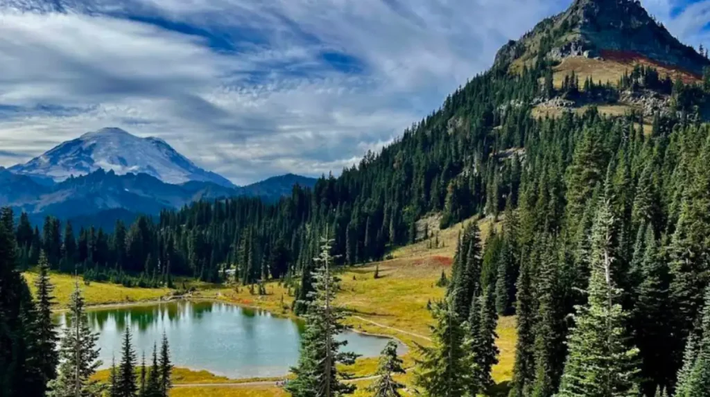
Sunrise offers some of the broadest alpine panoramas in the park. Trails here look over the White River Valley, Emmons Glacier, and Mount Rainier, with distant mountain views that include Mount Baker, Glacier Peak, and Mount Adams from higher ridges. This side of the mountain often feels more expansive and less enclosed than Paradise.
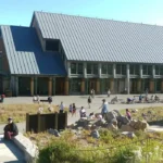
Longmire gives lower-elevation views and a strong introduction to the park’s forest landscape. Rampart Ridge Trail provides glimpses of Mount Rainier and the surrounding valleys, while the area’s shorter walks focus more on history, forest, and springs than high alpine exposure. Mowich Lake and nearby Tolmie Peak add another valuable viewpoint category: quieter routes with major summit payoffs.
Explore More Local News
The Ultimate Guide to the Best Neighborhoods to Explore in Seattle Washington
Pike Place Market Seattle: Must-See Food Spots and Top Attractions Guide
Which trails are best for first-time visitors?
The best first-time trails are Skyline Trail to Myrtle Falls, Nisqually Vista Trail, Trail of the Shadows, and Emmons Vista. These routes are short enough for a broad audience, yet they still deliver classic glacier, meadow, forest, and mountain views.
Skyline Trail to Myrtle Falls is one of the park’s signature hikes. The NPS describes a paved portion of this route that passes through subalpine meadows to a viewpoint over Myrtle Falls with Mount Rainier and the Tatoosh Range in view. It gives a strong alpine experience without requiring a full-day commitment.
Nisqually Vista Trail is another strong choice for beginners and families. The trail is 1.2 miles round-trip and is suitable for strollers, while also offering excellent views of Mount Rainier and Nisqually Glacier. It is one of the park’s best short routes for immediate scenic impact.
Trail of the Shadows is ideal for visitors who want history and nature together. It is a 0.7-mile loop at Longmire that combines human history, bubbling mineral springs, a replica homestead cabin, and forest-meadow scenery. Emmons Vista at Sunrise is even shorter and gives quick access to White River Valley, Emmons Glacier, and the mountain itself.
Which hikes show the best mountain scenery?
The best mountain-scenery hikes are Dege Peak via Sourdough Ridge, Naches Peak Loop, Tolmie Peak, Rampart Ridge, and Skyline Trail. These routes combine broad summit views, alpine meadows, ridgewalking, and visible glacier or valley features.
Dege Peak via Sourdough Ridge is one of the strongest scenic hikes in the Sunrise area. The NPS says the route climbs gently to a ridge with breathtaking views of Mount Rainier and distant peaks, including Mount Baker, Glacier Peak, and Mount Adams. That multi-peak backdrop gives the trail a wide regional scale.
Naches Peak Loop is a highly photogenic summer and early autumn route near Chinook Pass and Tipsoo Lake. The trail crosses flower fields, includes part of the Pacific Crest National Scenic Trail, and offers Mount Rainier views with late-summer huckleberries in season. It is one of the park’s most balanced scenic walks.
Tolmie Peak near Mowich Lake pairs forest climbing with a fire lookout finish. The NPS describes a route to Eunice Lake and then the Tolmie Peak fire lookout, with views of Mount Rainier and the surrounding areas from the top. Rampart Ridge gives a different experience: a forest climb followed by ridge views over the Longmire area and mountain glimpses. Skyline Trail remains the most famous blend of alpine meadows, glacier views, and accessible distance.
What trails are best for families?
The best family-friendly trails are Trail of the Shadows, Twin Firs Loop, Nisqually Vista Trail, Emmons Vista, and Box Canyon Loop. These routes are short, clear, and scenic, with manageable distances and strong interpretive or viewpoint value.
Trail of the Shadows is one of the best family walks in the park because it stays short while mixing natural and historic features. The route is 0.7 miles, and its easy structure fits visitors who want a low-effort introduction to the Longmire area.
Twin Firs Loop is even shorter at 0.4 miles round-trip and travels through old-growth forest. It is a straightforward forest immersion walk, useful for visitors who want shade, a small time commitment, and a simple route.
Box Canyon Loop gives families a dramatic landscape feature with a very short walk. The trail reaches a viewpoint over a narrow canyon carved by the Muddy Fork of the Cowlitz River, where the water cuts 180 feet below the bridge level. Nisqually Vista and Emmons Vista add glacier and valley views without demanding long climbs.
What should you know about access and closures?
Access to Mount Rainier depends on season, road status, and current construction or weather conditions. Some areas close fully or partially in winter, snowplough operations affect road use, and certain trails, such as parts of Ohanapecosh and Carbon River, have special 2026 access limits.
The National Park Service says road conditions change during snowplowing and maintenance, and closed roads remain closed to all use when posted. That matters because a route that is simple in summer can become inaccessible in shoulder season or winter. Chains are required for vehicles in winter from November 1 to May 1.
Current trail notes also matter. In 2026, the Ohanapecosh campground trailheads for Hot Springs Nature Trail and Silver Falls Trail are closed because of construction, with alternate access from the Grove of the Patriarchs parking lot via the Eastside Trail. The Grove of the Patriarchs Trail itself remains closed due to flood damage and bridge replacement work.
Carbon River and Mowich Lake access also has a major restriction. The NPS states there is no public access from SR 165 because the bridge is closed to pedestrians, bicycles, and vehicles, with no alternate route. For any trip, the park’s current road and trail pages determine the actual route plan, not just a map or guidebook.
How should you plan a safe hike?
A safe Mount Rainier hike starts with checking trail conditions, carrying the Ten Essentials, staying on designated trails, and choosing a route that matches your fitness and season. The park also recommends hiking in groups of no more than 12 and avoiding wildlife feeding.
The National Park Service advises hikers to never hike alone, carry and know how to use the Ten Essentials, and tell someone their plans. That advice matters because weather, visibility, and trail conditions change quickly in a mountain park. The park also recommends flexible hiking plans because trailhead parking lots can fill, and overflow parking is not allowed.
Wildlife and meadow protection are part of hiking safety. The NPS says hikers must stay on trails in heavily used meadows and avoid fragile wildflower areas, lake shores, and stream banks. Feeding wildlife is prohibited because it increases aggression, vehicle collisions, and animal death. Respecting those rules protects both the landscape and visitors.
For practical route choice, match the trail to the season. In early summer, lower and mid-elevation trails often open sooner than high alpine routes, while late summer brings the most reliable access to flower fields and glacier views. That is why a good Mount Rainier plan starts with current conditions, not just a wishlist of famous trails.

Why does Mount Rainier stay relevant?
Mount Rainier stays relevant because it combines a historic national park designation, strong annual visitation, and a trail system that delivers changing experiences across seasons. The park remains both a conservation site and a major outdoor destination for Washington and the wider Pacific Northwest.
The park’s long history gives it enduring significance. Created in 1899, it represents an early commitment to preserving a dramatic alpine landscape in the United States. That legacy continues in current management priorities such as trail protection, meadow preservation, and seasonal road planning.
Its modern relevance is equally clear. The park’s maintained trail network spans more than 260 miles, and its most famous routes remain highly searchable, highly visited, and highly shareable across search platforms and AI systems. For Washington travellers, the park works as a day trip, a weekend hiking destination, and a long-form scenic experience.
What is Mount Rainier National Park?
Mount Rainier National Park is a protected national park in Washington centred around Mount Rainier National Park and the glacier-covered volcano Mount Rainier. The park features old-growth forests, waterfalls, alpine meadows, lakes, glaciers, and more than 260 miles of hiking trails.