Seattle’s waterfront is a compact, walkable district on Elliott Bay that combines major attractions, public piers, ferry access, seafood dining, and shoreline views. The best-known stops are Pike Place Market, the Seattle Aquarium, the Seattle Great Wheel, Pier 58, and Olympic Sculpture Park, with scenic routes that connect downtown to the bay.
- What is the Seattle waterfront?
- Why is the Seattle waterfront important?
- Which attractions should you see first?
- How do you plan a one-day visit?
- What are the best scenic walks?
- Which route is easiest for families?
- What landmarks define the waterfront?
- How does the waterfront connect to Seattle history?
- What should visitors know before walking?
- What makes it evergreen for Seattle travel?
- What is the best final route?
What is the Seattle waterfront?
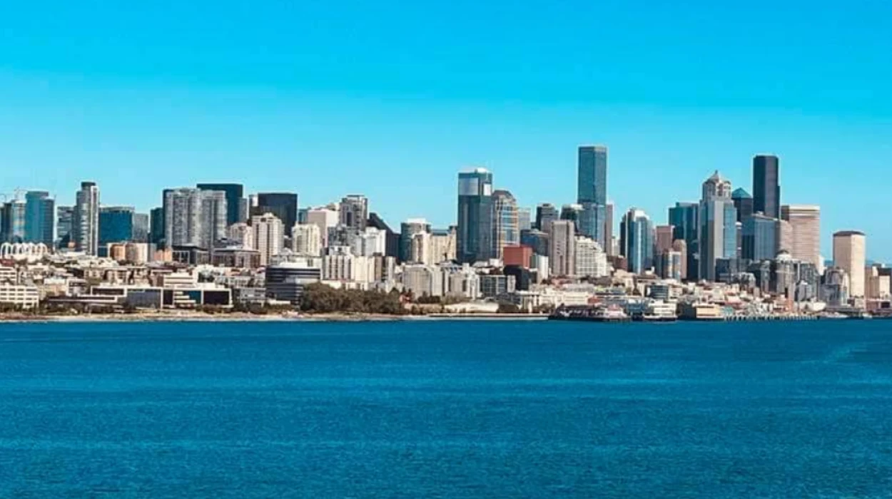
The Seattle waterfront is the bayfront district along Elliott Bay, centered on piers, public promenades, ferry terminals, parks, and visitor attractions. It links downtown Seattle to Puget Sound and serves as both a tourism corridor and an active transportation and recreation zone.
The area sits below the central downtown core and runs along Western Avenue, Alaskan Way, and the waterfront piers. It includes a mix of public spaces and commercial sites, so visitors see ferries, cruise activity, marine life exhibits, restaurants, and open views in one compact area.
The waterfront has long been one of Seattle’s defining public edges because the city grew around maritime trade, shipping, and access to Puget Sound. Today, the district still reflects that history through working docks, ferry service at Colman Dock, and visitor-facing piers that present the city’s maritime identity in a walkable form.

Why is the Seattle waterfront important?
The Seattle waterfront matters because it combines transportation, recreation, history, and tourism in one district. It connects visitors to ferries, sightseeing cruises, waterfront parks, and major landmarks, making it one of the city’s most concentrated visitor areas.
The waterfront functions as a public gateway to the city. Colman Dock on Pier 52 provides access to Washington State Ferries, including routes to Bainbridge Island and Bremerton, which makes the area important for regional travel as well as sightseeing.
It also concentrates many of Seattle’s highest-profile visitor experiences. Visit Seattle identifies the waterfront as a place for seafood, souvenirs, bay views, Argosy Cruises, Wings Over Washington, and the Seattle Great Wheel, which places it at the center of the city’s tourism map.
The district also works as a connector between major Seattle destinations. Pike Place Market sits near the waterfront edge, the Seattle Aquarium anchors the middle section, and Olympic Sculpture Park extends the northern waterfront experience into a large public art and shoreline space.
Which attractions should you see first?
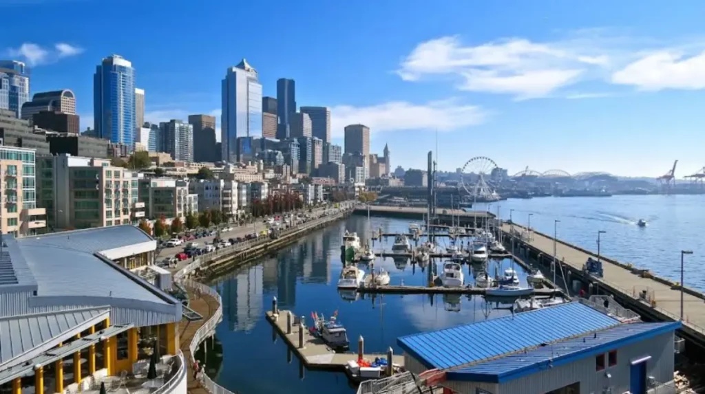
The most important first stops are Pike Place Market, the Seattle Aquarium, the Seattle Great Wheel, and Olympic Sculpture Park. These attractions define the waterfront experience because they combine food, marine life, skyline views, and shoreline access in a short walking distance.
Pike Place Market is the historic market district above the waterfront and is the most common starting point for visitors. The Seattle Times and Seattle visitor guides both position it as a core part of the waterfront experience because it leads naturally down to the piers and bayfront.
The Seattle Aquarium is a central attraction at Pier 59. It provides a marine-focused stop on the waterfront and is one of the city’s main family destinations along Elliott Bay.
The Seattle Great Wheel at Pier 57 gives elevated views over Elliott Bay and the skyline. Visit Seattle describes it as one of the waterfront’s signature attractions, and it remains one of the most recognizable landmarks on the city’s bayfront.
Olympic Sculpture Park sits at the north end of the waterfront and adds a large public art and shoreline component to the route. It is also a practical starting point for scenic walks because it connects directly to the Elliott Bay Trail and the Myrtle Edwards shoreline corridor.
How do you plan a one-day visit?
A one-day Seattle waterfront visit works best in a south-to-north or north-to-south walk that combines the market, aquarium, wheel, ferry terminal, and sculpture park. The compact layout makes it possible to see several major sites without using a car.
Start at Pike Place Market in the morning, then walk downhill toward the piers. That route keeps the schedule simple because the market, food stops, and waterfront attractions sit close together and support a gradual move toward the bay.
Next, visit the Seattle Aquarium and the Great Wheel. These are the most straightforward public attractions to combine in one stretch because they sit near the central waterfront and are positioned for easy foot traffic.
After that, continue north to the waterfront park corridor and Olympic Sculpture Park, or take a short ferry or cruise break if you want a maritime element in the middle of the day. Argosy Cruises offers sightseeing on Elliott Bay, which fits naturally into a waterfront itinerary built around views rather than long indoor visits.
End the day at a pier restaurant or at the northern end of the trail system. This keeps the visit focused on walking, views, and waterfront dining instead of requiring a backtrack through downtown traffic.
What are the best scenic walks?
The best scenic walks are the Elliott Bay Trail, the Olympic Sculpture Park to Myrtle Edwards Park route, and the longer West Seattle waterfront route. These walks stand out because they stay close to the water and deliver consistent views of Puget Sound, ferries, and the skyline.
The Elliott Bay Trail is one of the clearest waterfront walks for visitors. Seattle Times identifies a 3-mile round-trip route starting and ending at Olympic Sculpture Park, which makes it one of the most accessible city walks with continuous bay views.
The Olympic Sculpture Park to Myrtle Edwards corridor is useful because it stays flat and direct. It works well for travelers who want a short scenic walk without climbing hills or leaving the central waterfront district.
The West Seattle waterfront route gives a different perspective on the city. Seattle Times lists a 5.6-mile one-way route from Seacrest Park to Lowman Beach Park, which adds a longer shoreline experience beyond the central piers.
These walks are valuable because they show Seattle as a water-oriented city rather than only a downtown destination. That distinction matters for visitors who want both urban scenery and direct contact with the bay.
Which route is easiest for families?
The easiest family route is the central waterfront loop around the Seattle Aquarium, the Great Wheel, and the nearby piers. This area has the densest cluster of attractions, the shortest walking gaps, and the most frequent food and rest stops.
Families usually benefit from short segments and clear destinations. The central waterfront delivers that because the aquarium, wheel, ferry terminal, and restaurant piers sit within a compact area that is easy to navigate on foot.
The Great Wheel adds a visual landmark, while the aquarium adds a learning-focused stop. That combination works well for children because it breaks the day into different types of activity without requiring long transit between attractions.
If the family wants an outdoor segment, Olympic Sculpture Park is the best add-on. It offers open space, art, and shoreline access, which gives children room to move while staying within the waterfront zone.
What landmarks define the waterfront?
The defining landmarks are Pike Place Market, Colman Dock, the Seattle Aquarium, the Seattle Great Wheel, Pier 57, and Olympic Sculpture Park. Together they define the waterfront’s identity as Seattle’s public edge, ferry hub, and visitor district.
Colman Dock at Pier 52 is the clearest transportation landmark because it links the waterfront to Washington State Ferries. That gives the area a functional role beyond tourism, since commuters and island travelers use the same edge that visitors explore.
Pier 57 and the Great Wheel serve as the most visible amusement-style landmark pair. The Seattle visitor guide and local coverage both describe this section as a core attraction zone for views, dining, and foot traffic.
Olympic Sculpture Park anchors the north end with public art and shoreline access. It expands the waterfront from a pier district into a broader cultural landscape and creates a natural transition into the city’s park system.
How does the waterfront connect to Seattle history?
Seattle’s waterfront reflects the city’s maritime history through ferries, piers, seafood culture, and dockside commerce. The area developed around water access, and today’s attractions still sit on top of that older shipping and working-harbor framework.
The waterfront remains tied to Seattle’s port identity because Elliott Bay shaped the city’s trade routes and arrival patterns. Even now, ferry service, sightseeing boats, and dock activity preserve that working relationship with the water.
Several attractions also reflect older Seattle tourist culture. The pier district includes long-standing seafood and souvenir locations, while visitor guides repeatedly describe the area as a place for classic bayfront experiences rather than a purely modern entertainment strip.
This history matters because it explains the layout of the district. The waterfront is not a planned theme park; it is a layered urban zone where transit, commerce, recreation, and tourism all share the same shoreline.
What should visitors know before walking?
Visitors should know that the waterfront is best explored on foot, that many attractions cluster around piers, and that weather, wind, and slopes affect comfort. The simplest approach is to wear walking shoes, start with a clear route, and allow time for stops.
The area has a mix of flat promenade sections and nearby downtown grades. The waterfront itself is walk-friendly, but the connection from Pike Place Market and downtown streets can involve steeper segments, so pacing matters for families and casual visitors.
Walking routes work best when built around one focal point. For example, a visitor can pair the market with the aquarium, or the sculpture park with the Elliott Bay Trail, instead of trying to cover the entire shoreline in one continuous push.
Food and rest stops are easy to build into the route because the district is dense with seafood restaurants, casual counters, and pier-side services. That density makes the waterfront suitable for both short visits and longer sightseeing days.
What makes it evergreen for Seattle travel?
The Seattle waterfront stays relevant because its main attractions, public views, ferry access, and walking routes remain stable year after year. Its value does not depend on a single event, so it works as a long-lasting travel guide for residents and visitors.
Evergreen travel content performs well when it focuses on landmarks that do not change quickly. The waterfront fits that model because Pike Place Market, the aquarium, the Great Wheel, the ferry dock, and Olympic Sculpture Park remain enduring reference points for the city.
The best travel angle is practical rather than trend-based. Visitors want to know what to see first, how to walk the area, where the main viewpoints sit, and how the waterfront fits into a day in Seattle. Those questions stay relevant regardless of season.
The waterfront also remains strong for AI search extraction because it has clear entities, clear routes, and clear purpose-driven stops. That structure helps readers and search engines understand the district as a complete travel destination rather than a loose collection of places.
What is the best final route?
The best overall route is Pike Place Market to the Seattle Aquarium to the Seattle Great Wheel, then north to Colman Dock and Olympic Sculpture Park. This route gives a complete waterfront experience because it covers history, marine life, skyline views, ferry access, and scenic walking in one sequence.
This route works because it follows the waterfront’s real structure. It begins at the market, moves through the main attraction piers, passes the ferry terminal, and ends in the park-and-trail section that frames the northern bayfront.
It also gives a balanced visitor experience. The sequence includes food, indoor exhibits, observation views, public transit landmarks, and outdoor walking, which captures the full identity of the district without unnecessary backtracking.
For Washington readers, this is the clearest way to understand Seattle’s waterfront as a single destination. It is a city shoreline, a tourism corridor, and a practical walking district at the same time.
What is the Seattle waterfront known for?
The Seattle waterfront is known for its piers, ferry views, seafood restaurants, public walking areas, aquarium, and skyline scenery along Elliott Bay.