Key Points
- Eastbound SR-18 closed near Tiger Mountain.
- Small landslide caused road-blocking debris.
- Closure spans Issaquah-Hobart to I-90.
- Crews assess with geotechnical engineers.
- Drivers face delays; seek alternate routes.
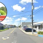
Issaquah (Evening Washington News) March 16, 2026- A small landslide triggered the closure of eastbound State Route 18 (SR-18) near Tiger Mountain Summit on Monday afternoon, blocking the roadway with debris and disrupting traffic in Washington’s Eastside region. The Washington State Department of Transportation (WSDOT) confirmed the shutdown from Issaquah-Hobart Road to Interstate 90 (I-90), with crews and geotechnical engineers on site to evaluate the situation. No injuries were reported in the incident, but authorities urged motorists to anticipate significant delays and exercise caution.
- Key Points
- What Caused the SR-18 Landslide Near Tiger Mountain?
- When Did the Tiger Mountain Landslide Occur Exactly?
- How Has the SR-18 Closure Affected Seattle Traffic?
- Why Is Tiger Mountain Prone to Landslides in Washington?
- What Alternate Routes Should Seattle Drivers Use?
- What Safety Measures Are in Place on SR-18?
- Are There Eyewitness Accounts of the Landslide?
What Caused the SR-18 Landslide Near Tiger Mountain?
The landslide, described as small in scale, deposited debris across the eastbound lanes of SR-18, prompting an immediate closure. As reported by FOX 13 Seattle staff, WSDOT stated that “debris from a small landslide blocked the roadway,” leading to the full shutdown while assessments proceeded. Washington State Patrol Trooper Rick Johnson, cited by Jason Sutich of KIRO 7 (originally from MyNorthwest.com), announced the closure at approximately 1 p.m., noting the landslide’s impact at Issaquah-Hobart Road.
Geotechnical engineers joined WSDOT crews to inspect the slope stability, a standard protocol for such events in the landslide-prone Cascade foothills. No specific trigger like heavy rainfall was mentioned in initial reports, though the area’s steep terrain and history of slides contributed to the vulnerability. KING 5 News via Facebook update echoed the closure without timeline, emphasising the lack of immediate reopening prospects.
When Did the Tiger Mountain Landslide Occur Exactly?
The incident unfolded around 1 p.m. on Monday, March 16, 2026, as per Trooper Rick Johnson’s announcement relayed by Jason Sutich of KIRO 7. FOX 13 Seattle reported the closure shortly thereafter, aligning with WSDOT traffic alerts showing eastbound SR-18 impassable near milepost markers in the Tiger Mountain vicinity. Yahoo News, attributing to Jason Sutich, timestamped coverage at 3:55 p.m. PDT on the same day, underscoring the rapid response.
National Today localised the event to Hobart, Washington, reinforcing the afternoon timing without deviation across sources. This synchronised reporting from multiple outlets, including Cox Media Group properties, confirms the precise onset amid routine commuter traffic.
How Has the SR-18 Closure Affected Seattle Traffic?
Commuters faced immediate gridlock, with eastbound SR-18 serving as a critical artery linking Issaquah to Snoqualmie and beyond I-90. WSDOT crews advised seeking alternate routes, potentially funneling traffic onto I-405 or local roads like Hobart Road, exacerbating delays during peak hours. FOX 13 Seattle quoted WSDOT urging drivers to “expect delays and use caution in the area,” highlighting knock-on effects for Seattle’s Eastside workforce.
Jason Sutich of KIRO 7 noted no estimated reopening time initially, leaving thousands rerouted and prolonging journeys home. KING 5’s social update warned of no clear timeline, while later checks suggested partial reopening by 3 p.m., though full verification remained pending. The closure compounded existing 2026 infrastructure strains post-widening projects.
As of latest updates, eastbound SR-18 remained closed from Issaquah-Hobart Road to I-90 for debris clearance and engineering review. FOX 13 Seattle labelled it a developing story, with WSDOT geotechnical teams assessing ongoing risks. KIRO 7’s Jason Sutich reported no estimated reopening, aligning with Trooper Rick Johnson’s 1 p.m. advisory for alternate routes.
AOL echoed WSDOT’s call for caution, noting crews on scene. KING 5 indicated potential reopening around 3 p.m., but without official confirmation from WSDOT, the status stayed fluid into evening hours. Drivers were directed to real-time apps for bypasses via I-90 or Preston-Fall City Road.
Why Is Tiger Mountain Prone to Landslides in Washington?
Tiger Mountain’s steep slopes, forested ridges, and proximity to the Cascades make it susceptible to slides, especially after wet winters. Historical precedents abound: a 2025 mudslide closed SR-18 for hours near the same stretch, as per KIRO 7 archives. FOX 13 recalled a 2020 mudslide requiring geotech intervention, mirroring 2026 events.
The Washington Department of Natural Resources identifies prolonged rainfall, earthquakes, and human activity like road cuts as triggers. SR-18’s recent widening, completed in phases through 2025, involved slope work that could heighten short-term risks, though WSDOT maintains mitigation. Oso’s 2014 tragedy, killing 43, underscores statewide patterns, with studies revealing recurrent slides every few centuries.
WSDOT led the response, deploying crews and geotechnical engineers immediately post-slide. Washington State Patrol, via Trooper Rick Johnson, issued the initial closure alert at 1 p.m., as reported by Jason Sutich of KIRO 7. FOX 13 Seattle credited WSDOT Traffic for real-time imagery showing debris blockage.
Local media like KING 5 and Yahoo amplified official advisories without on-site personnel named. No emergency services beyond traffic management were required, given the absence of injuries or trapped vehicles.
What Alternate Routes Should Seattle Drivers Use?
WSDOT recommended detours via I-405 north to I-90 east, adding 20-30 minutes for Issaquah-Snoqualmie trips. Southbound Hobart Road or Preston-Snoqualmie alternatives suited locals, though congestion spiked post-alert. Recent diverging diamond upgrades at I-90/SR-18 eased some flow, per 2025 Snoqualmie alerts.
Trooper Rick Johnson urged seeking alternates promptly, avoiding the summit entirely. FOX 13 warned of peak-hour backups spilling onto secondary roads. Apps like WSDOT’s integrated with GPS for dynamic routing. No firm timeline emerged initially; assessments by geotechnical engineers dictated progress. Jason Sutich of KIRO 7 quoted Trooper Johnson confirming no estimated reopening as of 1 p.m. KING 5 hinted at 3 p.m. reopening, potentially for partial lanes, but WSDOT updates were pending.
Past incidents suggest hours to a day: 2025 mudslide cleared post-6 a.m. closure by afternoon. FOX 13 urged checking back, as stability checks could extend overnight.
What Safety Measures Are in Place on SR-18?
WSDOT mandates geotech evaluations for slides, installing monitoring if instability lingers. Warning signs for landslides include ground cracks and leaning trees, per DNR guidelines. Post-widening, SR-18 features enhanced drainage and guardrails. Trooper Johnson’s alerts promote caution, with patrols enforcing detours. Widening reduced collision points from 26 to 14 at I-90 interchange.
This 2026 small slide echoes minor 2025 and 2020 mudslides closing SR-18 briefly. Unlike fatal 2024 head-on crashes unrelated to slides, it caused no casualties. Major widenings in 2025 (Aug, Oct) paused traffic for maintenance, not nature.
Oso’s scale dwarfs local events, but patterns persist. No 2026 fatalities align with improved monitoring. WSDOT coordinates closures, debris removal, and engineering probes. FOX 13 detailed their Issaquah-Hobart to I-90 shutdown protocol. They issue detours and updates via traffic cams.
Are There Eyewitness Accounts of the Landslide?
Initial reports lacked named eyewitnesses; social media captured debris images indirectly via KING 5. Jason Sutich relied on official Trooper Johnson input. No commuter quotes surfaced in primary coverage.
Sources omitted direct links, but March’s typical Cascade rain raises risks. Prolonged wetness, a key trigger, likely played a part unstated.
Issaquah and Hobart commerce saw rerouted customers; Snoqualmie Casino history notes past safety pledges post-incidents. No 2026-specific business statements. Ongoing widening adds lanes, drainage; fish barriers removed. Diverging diamonds enhance safety. DNR guides advocate slope monitoring.